RSS Feed Source: Science Daily

Researchers have developed a new way to create hydrogels using ultrasound, eliminating the need for toxic chemical initiators. This breakthrough offers a faster, cleaner and more sustainable approach to hydrogel fabrication, and produces hydrogels that are stronger, more flexible and highly resistant to freezing and dehydration. The new method also promises to facilitate advances in tissue engineering, bioadhesives and 3D bioprinting.

Click this link to continue reading the article on the source website.

RSS Feed Source: Science Daily

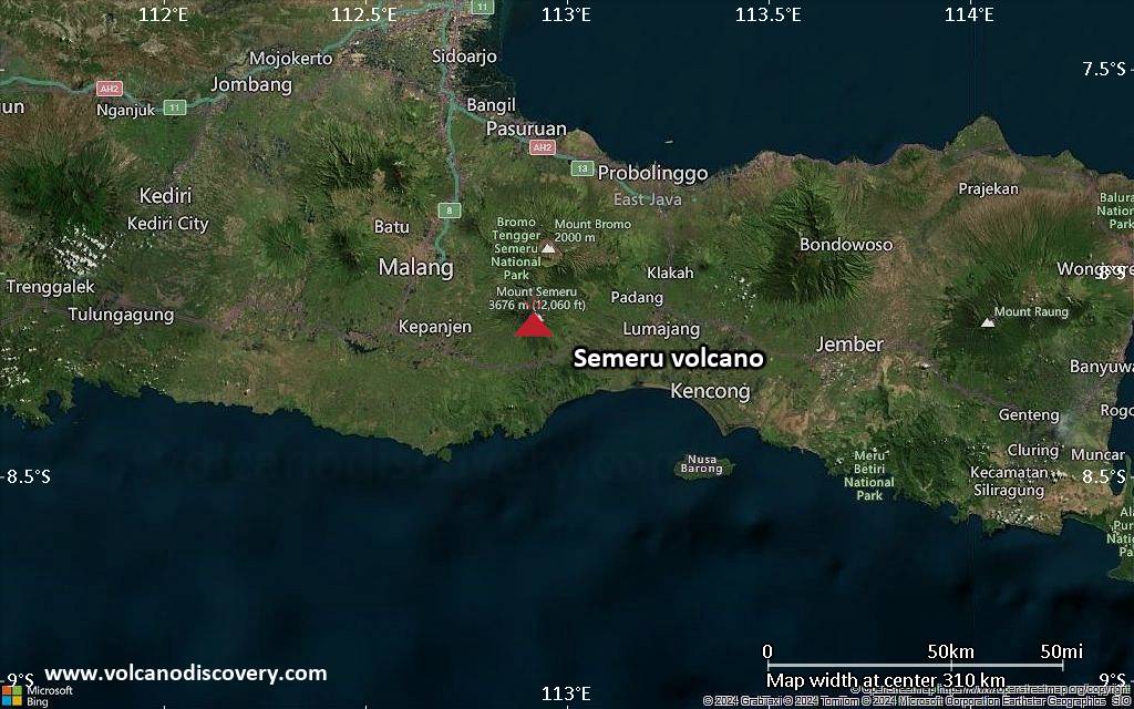
<!–div style="font-size:14px;text-align:center;border:3px solid blue;border-radius:5px;padding:3px;margin:5px;background:#eee"><a href="https://www.volcanoesandearthquakes.com/app/volcano-report.php?volcanoId=44" style="text-decoration:none" target="_blank" rel="noopener noreferrer nofollow" title="Share a volcano (activity) report, submit a photo or other interesting news!” onclick=”window.open(this.href,’Volcano Report’,’status=0,toolbar=0,location=0,directories=0,menubar=0,resizable=1,scrollbars=1,height=500,width=450′);return false”>Send Volcano Report</div–> Stratovolcano 3676 m (12,060 ft)
East Java, Indonesia, -8.11°S / 112.92°E
Current status: erupting (4 out of 5) Semeru volcano eruptions:
1818, 1829, 1830, 1832, 1836, 1838, 1842, 1844, 1845, 1848, 1849(?), 1851, 1856, 1857, 1865, 1866(?), 1887, 1887, 1888, 1889-91, 1892, 1893, 1893-94, 1895, 1896, 1897, 1899, 1899, 1900, 1901, 1903, 1904, 1905, 1907, 1908, 1909-10, 1910-11, 1911, 1912, 1913, 1941-42, 1945, 1946, 1946-47, 1950-64, 1967-ongoing
Typical eruption style
Explosive. Near constant strombolian activity, occasionally stronger explosions, lava flows and pyroclastic flows.

Click this link to continue reading the article on the source website.
RSS Feed Source: Science Daily

Date and TimeMag
DepthDistanceLocationDetailsMap May 4, 02:21 pm (GMT +10)

4.4

92 km32 km (20 mi) to the NE North Pacific Ocean, 50 km northeast of Agrihan Village, Northern Mariana IslandsI FELT IT InfoMay 2, 04:00 pm (GMT +10)

4.5

462 km68 km (43 mi) to the SW Philippine Sea, 52 km southwest of Agrihan Island, Northern Mariana Islands InfoApr 11, 01:18 pm (Saipan)

4.9

247 km36 km (22 mi) to the W Philippine Sea, 26 km northwest of Agrihan Island, Northern Mariana Islands InfoMar 28, 11:18 pm (GMT +10)

4.3

238 km37 km (23 mi) to the W Philippine Sea, 28 km northwest of Agrihan Island, Northern Mariana Islands InfoMar 15, 03:39 pm (Saipan)

4.8

176 km5.4 km (3.4 mi) to the NW Philippine Sea, 17 km northeast of Agrihan Island, Northern Mariana Islands InfoApr 5, 2024 09:03 pm (GMT +10)

6.8

222 km56 km (35 mi) to the NW Philippine Sea, 52 km northwest of Agrihan Island, Northern Mariana Islands 31 reportsInfoJan 21, 2024 01:48 am (GMT +10)

6.1

184 km38 km (24 mi) to the SW Philippine Sea, 25 km south of Agrihan Island, Northern Mariana Islands 1 reportInfoNov 19, 2023 02:01 pm (GMT +10)

5.9

585 km50 km (31 mi) to the W Philippine Sea, 37 km west of Agrihan Island, Northern Mariana Islands InfoJun 14, 2020 07:08 am (GMT +10)

6.1

624 km76 km (47 mi) to the W Philippine Sea, 65 km west of Agrihan Island, Northern Mariana Islands 7 reportsInfoFeb 12, 2019 10:34 pm (GMT +10)

5.9

142 km22 km (14 mi) to the NE Philippine Sea, 37 km northeast of Agrihan Island, Northern Mariana

Click this link to continue reading the article on the source website.

RSS Feed Source: Science Daily

Fri, 9 May 2025, 16:20 | BY: EARTHQUAKEMONITOR

Worldwide earthquakes above magnitude 3 during the past 24 hours on 9 May 2025

Summary: 2 quakes 5.0+, 29 quakes 4.0+, 147 quakes 3.0+, 288 quakes 2.0+ (466 total)
This report is being updated every hour.
Magnitude 5+: 2 earthquakes
Magnitude 4+: 29 earthquakes
Magnitude 3+: 147 earthquakes
Magnitude 2+: 288 earthquakes
No quakes of magnitude 6 or higherTotal seismic energy estimate: 2.9 x 10¹³ joules (8.05 gigawatt hours, equivalent to 6924 tons of TNT or 0.4 atomic bombs!) | equivalent to ONE quake of magnitude 5.8 learn more10 largest earthquakes in the world (past 24 hours)#1: Mag 5.6 Macquarie Island RegionFriday, May 9, 2025, at 09:01 am (GMT +11) – #2: Mag 5.1 Coral Sea, 80 km south of Vanikoro Island, Temotu Province, Solomon IslandsSaturday, May 10, 2025, at 02:17 am (GMT +11) – #3: Mag 4.9 Philippine Sea, 341 km southwest of Dededo Village, Dededo, GuamFriday, May 9, 2025, at 05:36 am (GMT +11) – #4: Mag 4.8 West of Macquarie IslandFriday, May 9, 2025, at 06:50 pm (GMT +9) – #5: Mag 4.7 Banda Sea, 72 km southeast of Pulau Menui Island, Sulawesi Tenggara, IndonesiaFriday, May 9, 2025, at 09:14 pm (Makassar time) – #6: Mag 4.7 Indian Ocean, 243 km east of Port Mathurin, Rodrigues, MauritiusFriday, May 9, 2025, at 05:52 am (GMT +4) – #7: Mag 4.6

Click this link to continue reading the article on the source website.