RSS feed source: US National Weather Service

At 918 PM CDT, Doppler radar was tracking a strong thunderstorm 18 miles southwest of Medicine Lake, or 27 miles southeast of Gordon, moving northeast at 30 mph. HAZARD…Wind gusts up to 40 mph and nickel size hail. SOURCE…Radar indicated. IMPACT…Gusty winds could knock down tree limbs and blow around unsecured objects. Minor hail damage to vegetation is possible. Locations impacted include… Intersection of Highway 61 and Shadbolt Road, Highway 61 crossing the Snake River, and Highway 61 Crossing The Niobrara River. This includes Highway 61 between mile markers 197 and 217.

Click this link to continue reading the article on the source website.

RSS feed source: US National Weather Service

At 817 PM MDT, severe thunderstorms were located near Powderville or 19 miles southwest of Ekalaka, moving northeast at 30 mph. HAZARD…60 mph wind gusts and half dollar size hail. SOURCE…Radar indicated. IMPACT…Hail damage to vehicles is expected. Expect wind damage to roofs, siding, and trees. Locations impacted include… Ekalaka, Ridgeway, Belltower, Hammond, Powderville, Boyes and Mill Iron.

Click this link to continue reading the article on the source website.
RSS feed source: US National Weather Service

Mon, 28 Apr 2025, 01:50 | BY: EARTHQUAKEMONITOR

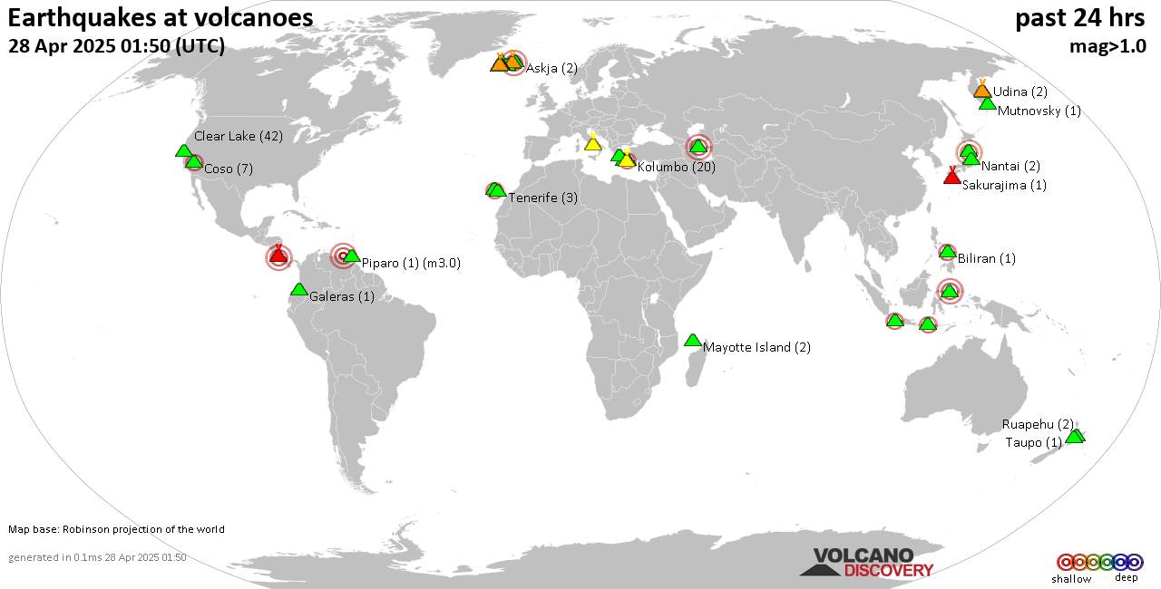
World map showing volcanoes with shallow (less than 50 km) earthquakes within 20 km radius during the past 24 hours on 28 Apr 2025 Number in brackets indicate nr of quakes.

Quakes detected near: Ambang (1 quake mag 3.0), Askja (2 quakes between mag 0.5-1.3), Bardarbunga (8 quakes between mag 0.1-3.0), Biliran (1 quake mag 2.1), Brennisteinsfjöll (3 quakes between mag 0.3-1.7), Campi Flegrei (Phlegrean Fields) (21 quakes between mag 0.1-1.6)
Chokai (2 quakes between mag 3.0-3.1), Clear Lake (42 quakes between mag 0.2-1.5), Coso (7 quakes between mag 0.9-2.1), Eldey (1 quake mag 1.4), Fagradalsfjall (26 quakes between mag 0.0-1.1), Galeras (1 quake mag 1.1), Klyuchevskoy (10 quakes between mag 0.4-1.8), Kolumbo (20 quakes between mag 0.8-2.3), Krísuvík (5 quakes between mag 0.4-1.3), La Palma (2 quakes between mag 2.1-2.1), Ljósufjöll (5 quakes between mag 0.8-1.6), Lokbatan (1 quake mag 3.0), Loki-Fögrufjöll volcano (4 quakes between mag 0.7-1.6), Mayotte Island (2 quakes between mag 1.0-1.5), Milos (2 quakes between mag 1.9-2.3), Mutnovsky (1 quake mag 1.1), Nantai (2 quakes between mag 0.1-1.2), Papandayan (1 quake mag 2.3), Piparo (1 quake mag 3.0), Poas (1 quake mag 3.0), Ruapehu (2 quakes between mag 0.8-1.0), Sakurajima (1 quake mag 1.1), Santorini (1 quake mag 1.9), Sousaki (2 quakes between mag 1.9-2.2), Svartsengi (15 quakes between mag 0.1-1.9),

Click this link to continue reading the article on the source website.

RSS feed source: US National Weather Service

Date and TimeMag
DepthDistanceLocationDetailsMap Apr 21, 03:47 am (Yangon)

4.3

10 km61 km (38 mi) to the SE 13 km north of Taungoo, Bago Region, Myanmar 2 reportsInfoApr 19, 06:20 pm (Yangon)

4.1

10 km112 km (69 mi) to the SE 18 km northeast of Pyu, Bago Region, Myanmar InfoApr 19, 12:04 am (Yangon)

4.4

10 km49 km (30 mi) to the E Kayin, 55 km southeast of Nay Pyi Taw, Nay Pyi Taw, Myanmar 3 reportsInfoApr 15, 11:54 pm (Yangon)

4.1

15 km98 km (61 mi) to the SE 14 km north of Pyu, Bago Region, Myanmar 4 reportsInfoApr 11, 08:47 pm (Yangon)

4.1

10 km81 km (51 mi) to the N 36 km north of Nay Pyi Taw, Nay Pyi Taw, Myanmar 7 reportsInfoApr 5, 08:24 pm (Yangon)

4.3

10 km43 km (27 mi) to the NE 24 km southeast of Nay Pyi Taw, Nay Pyi Taw, Myanmar 4 reportsInfoMar 30, 06:38 am (Yangon)

4.3

10 km34 km (21 mi) to the NE 30 km southeast of Nay Pyi Taw, Nay Pyi Taw, Myanmar 2 reportsInfoMar 30, 12:58 am (Yangon)

4.4

13 km87 km (54 mi) to the SE 19 km southeast of Taungoo, Bago Region, Myanmar 4 reportsInfoMar 29, 03:50 pm (Yangon)

5.1

10 km30 km (19 mi) to the N 19 km southwest of Nay Pyi Taw, Nay Pyi Taw, Myanmar 14 reportsInfoMar 29, 05:51 am (Yangon)

5.0

10 km73 km (45 mi) to the N 25 km north of Nay Pyi Taw, Nay Pyi Taw, Myanmar 3 reportsInfoOct 27, 2018 03:46 pm (Yangon)

4.9

10 km63 km (39 mi) to the SW Myanmar 1 reportInfoOct 10, 2018 04:58 pm (Yangon)

5.2

11 km54 km (34 mi) to the

Click this link to continue reading the article on the source website.