RSS feed source: Volcano Discovery.com--Global earthquake monitor

Date and TimeMag
DepthDistanceLocationDetailsMap Apr 19, 06:41 am (GMT +12)

5.4

10 km71 km (44 mi) to the S North Pacific Ocean, 124 km west of Ostrov Beringa Island, Kamchatka, Russia InfoApr 19, 05:40 am (GMT +11)

4.8

10 km59 km (37 mi) to the S 142 km SE of Ust’-Kamchatsk Staryy, Russia InfoMar 5, 10:01 am (Kamchatka)

4.1

6.6 km94 km (59 mi) to the W Bering Sea, 47 km east of Ust’-Kamchatsk Staryy, Ust-Kamchatsky District, Kamchatka, Russia InfoFeb 27, 06:07 am (GMT +12)

4.6

10 km49 km (30 mi) to the S 149 km ESE of Ust’-Kamchatsk Staryy, Russia InfoFeb 27, 04:15 am (GMT +12)

5.8

10 km57 km (35 mi) to the S Bering Sea, 118 km northwest of Ostrov Beringa Island, Kamchatka, Russia 2 reportsInfoNov 12, 2024 11:56 am (GMT +12)

4.9

10 km57 km (35 mi) to the E Bering Sea, 103 km northwest of Ostrov Beringa Island, Kamchatka, Russia InfoOct 27, 2023 04:05 am (GMT +12)

5.9

10 km12 km (7.6 mi) to the NE Bering Sea, 153 km northwest of Ostrov Beringa Island, Kamchatka, Russia InfoJun 26, 2019 02:18 pm (GMT +12)

6.3

10 km46 km (29 mi) to the NW Komandorskiye Ostrova Region 1 reportInfoJun 25, 2019 09:05 pm (GMT +12)

6.4

10 km41 km (25 mi) to the NW Komandorskiye Ostrova Region 3 reportsInfoDec 25, 2018 12:41 am (GMT +12)

6.0

31 km71 km (44 mi) to the S North Pacific Ocean, 122 km west of Ostrov Beringa Island, Kamchatka, Russia 7 reportsInfoDec 21, 2018 05:01 am (GMT +12)

7.3

17 km99 km (61 mi) to the S North Pacific Ocean, 101 km west of Ostrov Beringa Island, Kamchatka,

Click this link to continue reading the article on the source website.

RSS feed source: Volcano Discovery.com--Global earthquake monitor

Sun, 27 Apr 2025, 02:37 | BY: EARTHQUAKEMONITOR

Just 12 minutes ago, a 4.9-magnitude earthquake struck near Banda Aceh, Kota Banda Aceh, Nanggroe Aceh Darussalam Province, Indonesia. The tremor was recorded in the morning on Sunday, April 27th, 2025, at 8:23 am local time, at an intermediate depth of 134. km below the surface.
The event was filed by Indonesia’s Meteorology, Climatology, and Geophysical Agency, the first seismological agency to report it.
Towns or cities near the epicenter where the quake might have been felt as very weak shaking include Sabang (pop. 42,100) located 81 km from the epicenter, and Banda Aceh (pop. 255,000) 97 km away.
VolcanoDiscovery will automatically update magnitude and depth if these change and follow up if other significant news about the quake become available. If you’re in the area, please send us your experience through our reporting mechanism, either online or via our mobile app. This will help us provide more first-hand updates to anyone around the globe who wants to know more about this quake.

If you felt it, report it through our site or app right now!

Download and Upgrade the Volcanoes & Earthquakes app to get one of the fastest seismic alerts online:
Android | IOS
Earthquake data:

I felt this quake

Date & time: Apr 27, 2025 08:23 am (GMT +6) local time (27 Apr 2025 02:23 GMT)
Magnitude: 4.9
Depth: 134.00 km
Epicenter latitude

Click this link to continue reading the article on the source website.

RSS feed source: Volcano Discovery.com--Global earthquake monitor

Date and TimeMag
DepthDistanceLocationDetailsMap Apr 23, 10:27 am (GMT +6)

4.8

34 km84 km (52 mi) to the S Indian Ocean, 57 km southwest of Pulau Breueh Island, IndonesiaI FELT IT InfoMar 7, 06:42 pm (GMT +6)

5.2

51 km95 km (59 mi) to the S Indian Ocean, 65 km southwest of Pulau Breueh Island, Indonesia 1 reportInfoFeb 12, 04:37 pm (GMT +5:30)

4.0

87 km34 km (21 mi) to the W Bay of Bengal, 77 km northwest of Pulau Breueh Island, Indonesia InfoNov 28, 2024 02:05 am (GMT +6)

4.2

10 km77 km (48 mi) to the N Andaman Sea, 105 km east of Great Nicobar Island, India InfoNov 25, 2024 04:45 pm (GMT +5:30)

4.0

122 km81 km (50 mi) to the NWAndaman Sea, 82 km east of Great Nicobar Island, India InfoOct 13, 2024 02:01 pm (GMT +7)

5.3

43 km98 km (61 mi) to the SW Indian Ocean, 90 km west of Pulau Breueh Island, Indonesia 2 reportsInfoNov 4, 2023 07:57 am (Jakarta)

4.9

10 km66 km (41 mi) to the SE Andaman Sea, 10.4 km south of Pulau We Island, Indonesia InfoSep 12, 2023 05:09 am (GMT +7)

5.2

102 km51 km (32 mi) to the SW Bay of Bengal, 58 km west of Pulau Breueh Island, Indonesia 1 reportInfoJul 9, 2023 09:09 pm (GMT +7)

5.5

24 km88 km (54 mi) to the S Indian Ocean, 49 km southwest of Pulau Breueh Island, Indonesia 4 reportsInfoNov 8, 2015 10:17 pm (GMT +5:30)

6.4

10 km79 km (49 mi) to the NW Andaman Sea, 84 km east of Great Nicobar Island, India 10 reportsInfoMay 9, 2010 12:59

Click this link to continue reading the article on the source website.
RSS feed source: Volcano Discovery.com--Global earthquake monitor

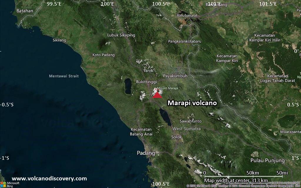
<!–div style="font-size:14px;text-align:center;border:3px solid blue;border-radius:5px;padding:3px;margin:5px;background:#eee"><a href="https://www.volcanoesandearthquakes.com/app/volcano-report.php?volcanoId=62" style="text-decoration:none" target="_blank" rel="noopener noreferrer nofollow" title="Share a volcano (activity) report, submit a photo or other interesting news!” onclick=”window.open(this.href,’Volcano Report’,’status=0,toolbar=0,location=0,directories=0,menubar=0,resizable=1,scrollbars=1,height=500,width=450′);return false”>Send Volcano Report</div–> Stratovolcano 2891 m (9,485 ft)
Western Sumatra, Indonesia, -0.39°S / 100.46°E
Current status: erupting (4 out of 5) Marapi volcano eruptions:
2011-ongoing, 2004 (Aug), 2001, 2000, 1999, 1987-94, 1984, 1984, 1983, 1982, 1980, 1975-79, 1973, 1970-71, 1968(?), 1967, 1966, 1958, 1958, 1954-57, 1950-52, 1949, 1949, 1943, 1932, 1930, 1929, 1927, 1925, 1919, 1918, 1918, 1917, 1916, 1915, 1913, 1911, 1910, 1907-08, 1905, 1904, 1889, 1888, 1886, 1885, 1883, 1878(?), 1883, 1876-77, 1876, 1871, 1871, 1863, 1861, 1855-56, 1854, 1845, 1833-34, 1822, 1807, 1770
Typical eruption style
Small to moderate sized explosions

Click this link to continue reading the article on the source website.