RSS feed source: Volcano Discovery.com--Global earthquake monitor

Wednesday, Nov 19, 2025 06:20 | 4 mins ago | By: EarthquakeMonitor

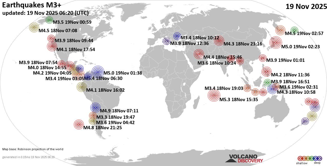
Worldwide earthquakes above magnitude 3 during the past 24 hours on 19 Nov 2025

Summary: 5 quakes 5.0+, 23 quakes 4.0+, 139 quakes 3.0+, 339 quakes 2.0+ (506 total)
This report is being updated every hour.
Magnitude 5+: 5 earthquakes
Magnitude 4+: 23 earthquakes
Magnitude 3+: 139 earthquakes
Magnitude 2+: 339 earthquakes
No quakes of magnitude 6 or higherTotal seismic energy estimate: 3.5 x 10¹³ joules (9.58 gigawatt hours, equivalent to 8247 tons of TNT or 0.5 atomic bombs!) | equivalent to ONE quake of magnitude 5.8 learn more10 largest earthquakes in the world (past 24 hours)#1: Mag 5.4 North Pacific Ocean, 144 km south of San Jose, Provincia de San Jose, Costa RicaTuesday, Nov 18, 2025, at 12:30 am (GMT -6) – #2: Mag 5.4 North Pacific Ocean, Provincia de Puntarenas, 73 km southwest of San Isidro, Costa RicaTuesday, Nov 18, 2025, at 04:36 pm (Costa Rica time) – #3: Mag 5.3 Mid-Indian RidgeTuesday, Nov 18, 2025, at 07:35 pm (GMT +4) – #4: Mag 5.0 North Pacific Ocean, 206 km east of Morioka, Iwate, JapanWednesday, Nov 19, 2025, at 12:23 pm (GMT +10) – #5: Mag 5.0 Caribbean Sea, 60 km northwest of Gueiria, Sucre, VenezuelaTuesday, Nov 18, 2025, at 09:38 pm (Caracas time) – #6: Mag 4.9 76 km west of San Antonio

Click this link to continue reading the article on the source website.

RSS feed source: Volcano Discovery.com--Global earthquake monitor

Support Us – Help Us Enhance Our Services! We’re passionate about delivering the latest volcano and earthquake data from around the globe — just for you. However, maintaining our website and free apps requires significant time, effort, and resources.
Your support helps us expand our hardware and software capabilities and empowers our dedicated editorial team. Our mission is to provide uninterrupted, real-time updates whenever an earthquake strikes or a volcano erupts — and your donations make this possible. Every contribution, big or small, is deeply appreciated. If you find our information valuable and want to help us add new features, create compelling content, and improve our technology, please consider making a donation: Donate with PayPal: Planned Features: Improved multilingual support Tsunami alerts Faster responsiveness Thanks to your past donations, we have recently added: Design upgrades Detailed earthquake

Click this link to continue reading the article on the source website.

RSS feed source: Volcano Discovery.com--Global earthquake monitor

Date and TimeMag
DepthDistanceLocationDetailsMap Nov 16, 02:45 am (GMT -6)

4.0

5 km70 km (43 mi) to the E North Pacific Ocean, 51 km southwest of Crucecita, Estado de Oaxaca, MexicoI FELT IT InfoNov 16, 02:37 am (GMT -6)

4.1

5 km65 km (40 mi) to the E North Pacific Ocean, 62 km southeast of Puerto Escondido, MexicoI FELT IT InfoNov 10, 11:09 pm (GMT -6)

4.3

16 km33 km (21 mi) to the SW 52 km southwest of Puerto Escondido, Estado de Oaxaca, Mexico 8 reportsInfoOct 25, 06:02 am (GMT -6)

4.0

5 km13 km (7.9 mi) to the SW North Pacific Ocean, 32 km southwest of Puerto Escondido, Mexico 1 reportInfoOct 25, 12:00 am (Mexico City)

4.0

13 km80 km (49 mi) to the E North Pacific Ocean, 44 km southwest of Crucecita, Estado de Oaxaca, Mexico InfoJul 16, 2024 08:29 am (Mexico City)

5.0

15 km82 km (51 mi) to the NW 38 km east of Pinotepa Nacional, Estado de Oaxaca, Mexico 16 reportsInfoJun 15, 2023 08:03 pm (GMT -6)

5.1

16 km77 km (48 mi) to the SE North Pacific Ocean, 56 km southwest of Crucecita, Estado de Oaxaca, Mexico 34 reportsInfoApr 3, 2023 08:11 pm (Mexico City)

5.4

31 km45 km (28 mi) to the NE Near Mexico, Ciudad de México, Mexico 149 reportsInfoMar 1, 2022 01:35 pm (Mexico City)

5.2

41 km64 km (40 mi) to the NE 44 km south of Miahuatlan de Porfirio Diaz, Estado de Oaxaca, Mexico 148 reportsInfoJun 22, 2021 09:55 am (Mexico City)

4.9

38 km39 km (24 mi) to the N 24 km north of Puerto Escondido, Estado de

Click this link to continue reading the article on the source website.

RSS feed source: Volcano Discovery.com--Global earthquake monitor

Date and TimeMag
DepthDistanceLocationDetailsMap Nov 16, 10:22 pm (GMT -6)

4.2

74 km46 km (28 mi) to the NE North Pacific Ocean, Departamento de San Miguel, 48 km southwest of Usulutan, El SalvadorI FELT IT6 reportsInfoNov 11, 10:54 am (GMT -6)

4.0

49 km74 km (46 mi) to the NW North Pacific Ocean, 67 km southwest of San Salvador, El Salvador InfoNov 8, 07:49 pm (GMT -6)

4.9

66 km45 km (28 mi) to the NE North Pacific Ocean, Departamento de San Salvador, 48 km southwest of Usulutan, El Salvador 41 reportsInfoNov 8, 07:49 pm (El Salvador)

4.9

74 km53 km (33 mi) to the NE North Pacific Ocean, 42 km southwest of Usulutan, El Salvador InfoNov 8, 12:40 am (GMT -6)

4.1

30 km18 km (11 mi) to the E North Pacific Ocean, 76 km southwest of Usulutan, El Salvador InfoNov 5, 11:21 pm (GMT -6)

4.6

64 km48 km (30 mi) to the NE North Pacific Ocean, 46 km southwest of Usulutan, El Salvador 2 reportsInfoNov 4, 07:38 pm (GMT -6)

4.4

35 km32 km (20 mi) to the SW North Pacific Ocean, 112 km south of San Salvador, El Salvador InfoJan 5, 11:18 am (GMT -6)

6.2

46 km24 km (15 mi) to the NW North Pacific Ocean, 77 km south of San Salvador, El Salvador 188 reportsInfoAug 28, 2024 03:57 pm (GMT -6)

6.1

26 km61 km (38 mi) to the NW North Pacific Ocean, 83 km southwest of San Salvador, El Salvador 99 reportsInfoDec 15, 2022 08:32 am (GMT -6)

5.7

90 km75 km (47 mi) to the E North Pacific Ocean, 44 km south

Click this link to continue reading the article on the source website.