RSS feed source: US National Weather Service

FFWFGZ The National Weather Service in Flagstaff has extended the * Flash Flood Warning for Fossil Creek. * Until 530 PM MST. * At 221 PM MST, Doppler radar indicated heavy rain across the warned area. Between 1.5 and 3 inches of rain have fallen. Additional rainfall amounts of 0.25 to 0.5 inches are possible in the warned area. Flash flooding is ongoing or expected to begin shortly. HAZARD…Life threatening flash flooding. Heavy rain producing flash flooding. SOURCE…Radar indicated. IMPACT…Life threatening flash flooding of creeks and streams, normally dry washes, urban areas, highways, streets and underpasses. This includes the following highways… State Route 260 near mile marker 248. State Route 87

Click this link to continue reading the article on the source website.

RSS feed source: US National Weather Service

Date and TimeMag
DepthDistanceLocationDetailsMap Nov 16, 06:09 pm (GMT -6)

4.2

31 km424 km (264 mi) to the NW North Pacific Ocean, 77 km south of Retalhuleu, GuatemalaI FELT IT InfoOct 28, 12:55 pm (Guatemala)

4.3

45 km427 km (265 mi) to the NW 74 km southwest of Escuintla, Departamento de Escuintla, Guatemala 2 reportsInfoOct 21, 05:06 pm (Guatemala)

4.7

182 km373 km (232 mi) to the NW Departamento de Escuintla, 30 km south of Guatemala City, Guatemala InfoOct 19, 01:05 am (GMT -6)

4.1

24 km350 km (218 mi) to the NW North Pacific Ocean, 31 km south of Puerto San Jose, Guatemala InfoOct 13, 06:47 pm (Guatemala)

4.2

5 km393 km (244 mi) to the NW Offshore Guatemala 1 reportInfoAug 26, 06:25 am (GMT -6)

5.0

35 km355 km (221 mi) to the W North Pacific Ocean, 115 km south of Masagua, Guatemala InfoAug 23, 03:14 am (GMT -6)

6.0

10 km281 km (175 mi) to the NW North Pacific Ocean, Departamento de San Salvador, 81 km southwest of Acajutla, El Salvador 86 reportsInfoAug 16, 11:59 pm (GMT -6)

5.4

10 km358 km (223 mi) to the W North Pacific Ocean, Departamento de Guatemala, 125 km south of Escuintla, Guatemala 2 reportsInfoJul 29, 03:42 pm (Guatemala)

4.8

10 km309 km (192 mi) to the NW 26 km south of Jutiapa, Departamento de Jutiapa, Guatemala 12 reportsInfoJul 29, 03:25 pm (Guatemala)

5.7

10 km304 km (189 mi) to the NW 26 km south of Jutiapa, Departamento de Jutiapa, Guatemala 37 reportsInfoJan 26, 2024 11:52 pm (Guatemala)

6.1

90 km363 km (225 mi) to the NW Departamento de Santa Rosa, 65 km south of Guatemala City, Guatemala

Click this link to continue reading the article on the source website.

RSS feed source: US National Weather Service

Increased moisture being brought in from the south is expected to bring increased chances for light to moderate snowfall into the Interior beginning Thursday night into Friday morning. Snow showers will likely move from east to west, impacting areas of the Eastern Interior first before becoming heavier and more widespread across the Central Interior Friday through Sunday. Snowfall accumulations may vary but will likely range between 1 to 4 inches, with localized snowfall above 6 inches possible. Exercise caution while driving this weekend and refer to Alaska 511 for road condition updates.

Click this link to continue reading the article on the source website.

RSS feed source: US National Weather Service

Wednesday, Nov 19, 2025 21:00 | 1 hour ago | By: several contributors

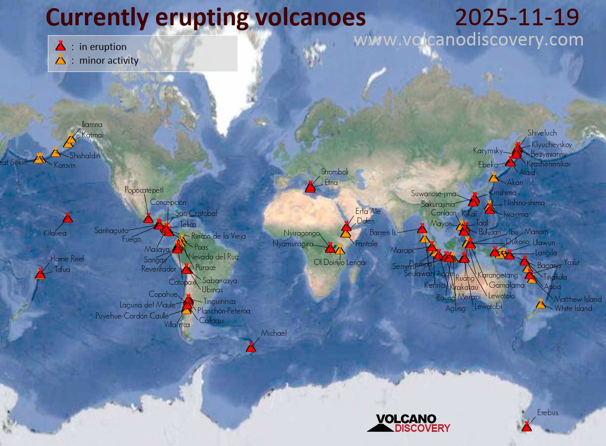
Map of today’s active volcanoes

Stromboli (Eolian Islands, Italy): The Instituto Nazionale di Geofisica e Vulcanologia-Osservatorio Etneo (INGV-Osservatorio Etneo) reported that the eruption continued at Stromboli on 18 November 2025 (local). The alert level remained at “Orange” (level 3 on a 4-level scale). The alert level remained at “Yellow” (level 2 on a 4-level scale).
Source: Instituto Nazionale di Geofisica e Vulcanologia-Osservatorio Etneo (INGV-Osservatorio Etneo)
… [read more]

Krasheninnikov (Kamchatka, Russia): The Kamchatkan Volcanic Eruption Response Team (KVERT) and Laboratory for Seismic and Volcanic Activity Research (ISVA) reported that the eruption continued at Krasheninnikov on 17 November 2025 (local). The aviation alert level remained at “Orange” (level 3 on a 4-level scale).

Source: Kamchatkan Volcanic Eruption Response Team (KVERT); Laboratory for Seismic and Volcanic Activity Research (ISVA)
… [read more]

Shiveluch (Kamchatka): The Kamchatkan Volcanic

Click this link to continue reading the article on the source website.