RSS feed source: Volcano Discovery.com--Global earthquake monitor

Support us – Help us upgrade our services! We truly love working to bring you the latest volcano and earthquake data from around the world. Maintaining our website and our free apps does require, however, considerable time and resources.
We need financing to increase hard- and software capacity as well as support our editor team. We’re aiming to achieve uninterrupted service wherever an earthquake or volcano eruption unfolds, and your donations can make it happen! Every donation will be highly appreciated. If you find the information useful and would like to support our team in integrating further features, write great content, and in upgrading our soft- and hardware, please make a donation (PayPal).

Planned features:

Improved multilanguage supportTsunami alertsFaster responsivenessThanks to your past donations, these features have been added recently:Design upgradeDetailed quake statsAdditional seismic data sourcesDownload and Upgrade the Volcanoes & Earthquakes app to get one of the fastest seismic and volcano alerts online:
Android | IOSThank you!

Click this link to continue reading the article on the source website.

RSS feed source: Volcano Discovery.com--Global earthquake monitor

Date and TimeMag
DepthDistanceLocationDetailsMap Dec 1, 2024 11:58 pm (GMT +0)

4.4

10 km43 km (27 mi) to the SENorth Atlantic Ocean InfoSep 21, 2024 11:34 pm (GMT +1)

3.6

2 km87 km (54 mi) to the SE Portugal: AZORES-CABO DE SAN VICENTE 1 report

Info

Jul 15, 2024 12:44 am (GMT +0)

4.2

31 km118 km (73 mi) to the SE North Atlantic Ocean, 247 km northeast of Funchal, Madeira, Portugal InfoDec 17, 2022 12:45 pm (GMT +0)

4.3

5 km92 km (57 mi) to the NE Portugal: AZORES-CABO DE SAN VICENTE InfoOct 25, 2021 02:47 am (GMT +0)

3.6

30 km75 km (46 mi) to the SE North Atlantic Ocean, 215 km north of Funchal, Madeira, Portugal

Info

Sep 17, 2020 02:52 am (GMT +0)

4.3

10 km91 km (57 mi) to the SE 199 km north of Funchal, Madeira, Portugal InfoSep 26, 2018 08:16 pm (GMT +0)

4.3

33 km15 km (9.5 mi) to the SW AZORES-CABO DE SAN VICENTE InfoSep 26, 2018 08:16 pm (GMT +0)

4.2

0 km28 km (17 mi) to the SE AZORES-CABO DE SAN VICENTE InfoMay 12, 2017 10:55 pm (GMT +0)

4.0

10 km59 km (37 mi) to the E Madeira Islands, Portugal Region InfoMay 27, 2016 04:47 am (GMT +0)

4.5

0 km84 km (52 mi) to the SE North Atlantic Ocean, 205 km north of Funchal, Madeira, Portugal InfoAug 23, 2015 07:44 pm (GMT +0)

4.3

10 km129 km (80 mi) to the SE North Atlantic Ocean, 244 km northeast of Funchal, Madeira, Portugal InfoJul 16, 2013 04:26 pm (Universal Time)

3.9

10 km31 km (19 mi) to the SEMadeira Islands, Portugal Region

Info

Mar 13, 2012 04:05 am (GMT +0)

4.2

30 km51 km (32 mi) to the SE North

Click this link to continue reading the article on the source website.
RSS feed source: Volcano Discovery.com--Global earthquake monitor

Volcanoes Today, 18 Jul 2025: Santiaguito volcano, Popocatépetl, Semeru, Ibu, Dukono, Marapi, Reventador, Erta Ale

Fri, 18 Jul 2025, 13:00 1752843605 | BY: VN

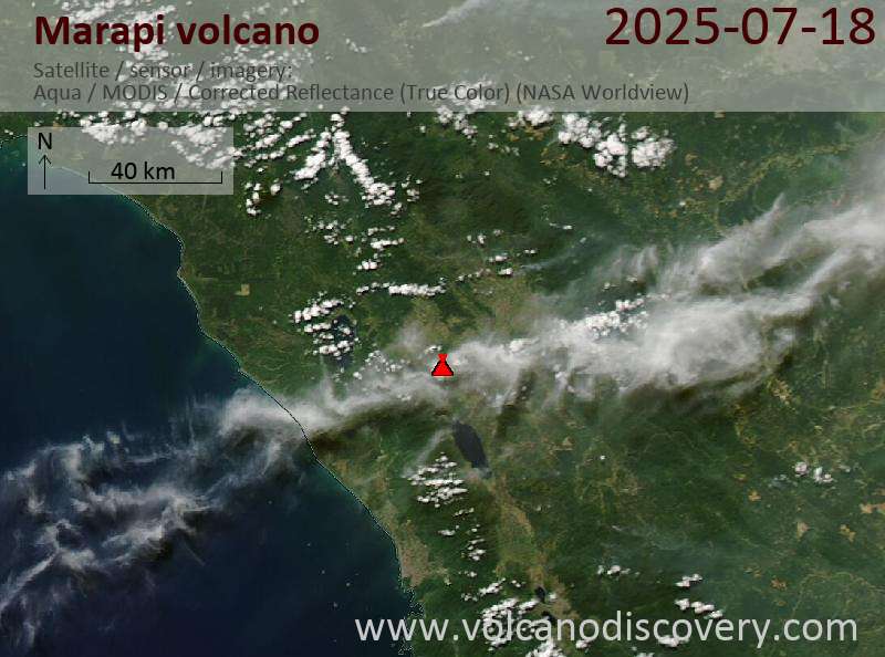
Satellite image of Marapi volcano on 18 Jul 2025

Satellite image of Reventador volcano on 17 Jul 2025

The timelapse combining Sentinel-1 and Sentinel-2 imagery shows an impressive morphology changes in the northern pit crater and 10 km long lava flow (image: European Space Agency)

Sakurajima (Kyushu, Japan): Volcanic Ash Advisory Center Tokyo (VAAC) issued the following report: ERUPTED AT 20250718/1100Z FL110 EXTD N OBS VA DTG:18/1050Z

Ibu (Halmahera, Indonesia): Explosive activity continues. Volcanic Ash Advisory Center (VAAC) Darwin warned about a volcanic ash plume that rose up to estimated 7000 ft (2100 m) altitude or flight level 070 .
The full report is as follows: VA TO FL070 MOV NE, LAST REPORTED AT 18/0854Z to 7000 ft (2100 m)

Lewotobi (Flores): Explosive activity continues. Volcanic Ash Advisory

Click this link to continue reading the article on the source website.

RSS feed source: Volcano Discovery.com--Global earthquake monitor

<!–div style="font-size:14px;text-align:center;border:3px solid blue;border-radius:5px;padding:3px;margin:5px;background:#eee"><a href="https://www.volcanoesandearthquakes.com/app/volcano-report.php?volcanoId=62" style="text-decoration:none" target="_blank" rel="noopener noreferrer nofollow" title="Share a volcano (activity) report, submit a photo or other interesting news!” onclick=”window.open(this.href,’Volcano Report’,’status=0,toolbar=0,location=0,directories=0,menubar=0,resizable=1,scrollbars=1,height=500,width=450′);return false”>Send Volcano Report</div–> Stratovolcano 2891 m (9,485 ft)
Western Sumatra, Indonesia, -0.39°S / 100.46°E
Current status: erupting (4 out of 5) Marapi volcano eruptions:
2011-ongoing, 2004 (Aug), 2001, 2000, 1999, 1987-94, 1984, 1984, 1983, 1982, 1980, 1975-79, 1973, 1970-71, 1968(?), 1967, 1966, 1958, 1958, 1954-57, 1950-52, 1949, 1949, 1943, 1932, 1930, 1929, 1927, 1925, 1919, 1918, 1918, 1917, 1916, 1915, 1913, 1911, 1910, 1907-08, 1905, 1904, 1889, 1888, 1886, 1885, 1883, 1878(?), 1883, 1876-77, 1876, 1871, 1871, 1863, 1861, 1855-56, 1854, 1845, 1833-34, 1822, 1807, 1770
Typical eruption style
Small to moderate sized explosions

Click this link to continue reading the article on the source website.