RSS feed source: Volcano Discovery.com--Global earthquake monitor

54 km (34 mi)

N of epicenter

La Libertad

(pop: 16,900)

III: Weak

Departamento de La Libertad 66 km (41 mi)

N of epicenter

Zaragoza

(pop: 11,700)

III: Weak

Departamento de La Libertad 71 km (44 mi)

NE of epicenter

El Rosario

(pop: 5,620)

III: Weak

Departamento de La Paz 75 km (47 mi)

NW of epicenter

Acajutla

(pop: 22,800)

III: Weak

Sonsonate 75 km (47 mi)

N of epicenter

Antiguo Cuscatlan

(pop: 33,800)

III: Weak

Departamento de La Libertad 76 km (47 mi)

N of epicenter

Santa Tecla

(pop: 124,700)

III: Weak

Departamento de La Libertad 77 km (48 mi)

N of epicenter

San Marcos

(pop: 54,600)

III: Weak

Departamento de San Salvador 78 km (48 mi)

NE of epicenter

Santo Tomas

(pop: 14,600)

III: Weak

Departamento de San Salvador 80 km (50 mi)

N of epicenter

San Salvador

(pop: 526,000)

III: Weak

Departamento de San Salvador 81 km (50 mi)

N of epicenter

Armenia

(pop: 15,000)

III: Weak

Sonsonate 83 km (51 mi)

N of epicenter

Sonsonate

(pop: 59,500)

III: Weak

Sonsonate 83 km (52 mi)

NE of epicenter

Zacatecoluca

(pop: 39,600)

III: Weak

Departamento de La Paz 84 km (52 mi)

N of epicenter

Mejicanos

(pop: 160,300)

III: Weak

Departamento de San Salvador 84 km (52

Click this link to continue reading the article on the source website.

RSS feed source: Volcano Discovery.com--Global earthquake monitor

Date and TimeMag
DepthDistanceLocationDetailsMap Apr 25, 08:11 am (GMT -6)

4.8

63 km13 km (7.9 mi) to the N North Pacific Ocean, 68 km south of San Salvador, El SalvadorI FELT IT24 reportsInfoApr 17, 08:24 am (GMT -6)

4.2

27 km62 km (38 mi) to the E North Pacific Ocean, 77 km southwest of Usulutan, Usulutan, El Salvador InfoApr 10, 01:35 pm (GMT -6)

4.2

59 km44 km (28 mi) to the E North Pacific Ocean, 71 km south of San Salvador, El Salvador 3 reportsInfoMar 24, 02:05 am (El Salvador)

4.2

166 km89 km (56 mi) to the NE 19 km southeast of Zacatecoluca, Departamento de La Paz, El Salvador InfoMar 22, 03:51 pm (GMT -6)

4.0

46 km21 km (13 mi) to the NE North Pacific Ocean, 66 km south of San Salvador, El Salvador InfoMar 20, 03:07 pm (GMT -6)

4.4

22 km20 km (12 mi) to the W 56 km Al Suroeste De La Libertad, El Salvador InfoMar 20, 03:07 pm (GMT -6)

4.3

32 km19 km (12 mi) to the NW North Pacific Ocean, 77 km southwest of San Salvador, El Salvador InfoMar 20, 02:15 am (GMT -6)

5.0

56 km66 km (41 mi) to the E North Pacific Ocean, 92 km southeast of San Salvador, El Salvador 13 reportsInfoMar 18, 08:47 pm (El Salvador)

4.8

151 km83 km (52 mi) to the NE 5 km east of San Salvador, Departamento de San Salvador, El Salvador InfoJan 5, 11:18 am (GMT -6)

6.2

46 km31 km (19 mi) to the E North Pacific Ocean, 77 km south of San Salvador, El Salvador 188 reportsInfoAug 28,

Click this link to continue reading the article on the source website.

RSS feed source: Volcano Discovery.com--Global earthquake monitor

Mon, 28 Apr 2025, 15:50 | BY: EARTHQUAKEMONITOR

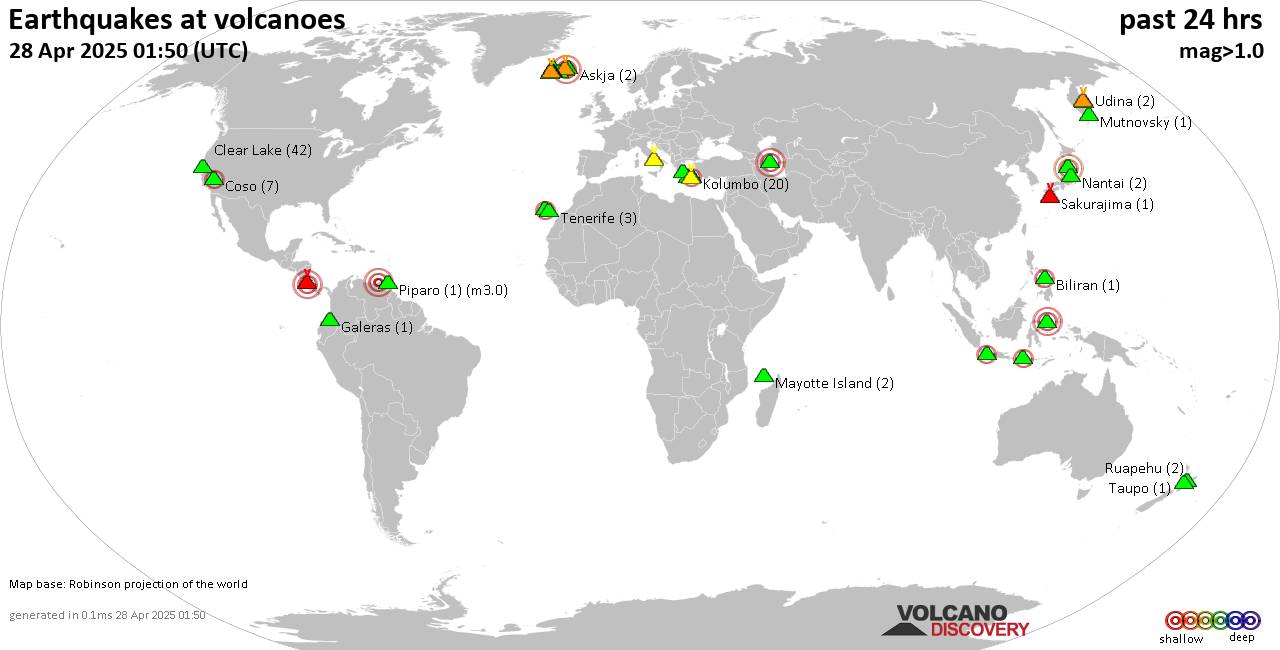
World map showing volcanoes with shallow (less than 50 km) earthquakes within 20 km radius during the past 24 hours on 28 Apr 2025 Number in brackets indicate nr of quakes.

Quakes detected near: Campi Flegrei (Phlegrean Fields) (15 quakes between mag 0.1-1.6), Chaîne des Puys (2 quakes between mag 1.1-2.3), Chokai (2 quakes between mag 3.0-3.1), Clear Lake (39 quakes between mag 0.4-1.9), Comondu-La Purisima (1 quake mag 2.3), Coso (6 quakes between mag 1.2-2.1)
Eldey (3 quakes between mag 1.4-2.2), Garibaldi (1 quake mag 3.0), Grímsvötn (3 quakes between mag 0.3-1.0), Haku-san (1 quake mag 1.1), Hiuchi (3 quakes between mag 0.7-1.5), Kilauea (1 quake mag 1.7), Kita Yatsugatake (1 quake mag 1.1), Klyuchevskoy (8 quakes between mag 1.1-1.8), Kolumbo (13 quakes between mag 1.1-2.1), Kukak (1 quake mag 1.4), La Palma (2 quakes between mag 2.1-2.1), Ljósufjöll (9 quakes between mag 0.5-2.3), Mayotte Island (3 quakes between mag 1.0-1.5), Methana (1 quake mag 3.8), Milos (1 quake mag 1.9), Mutnovsky (1 quake mag 1.1), Paco (1 quake mag 2.3), Platanar (1 quake mag 1.1), Reporoa (1 quake mag 1.6), San Cristobal (1 quake mag 1.6), Santorini (1 quake mag 1.2), Sousaki (1 quake mag 2.9), Svartsengi (20 quakes between mag 0.0-1.1), Tambora (1 quake mag 2.3), Taranaki (1 quake mag 1.3), Turrialba (1

Click this link to continue reading the article on the source website.
RSS feed source: Volcano Discovery.com--Global earthquake monitor

Mon, 28 Apr 2025, 10:55 | BY: EARTHQUAKEMONITOR

An earthquake of magnitude 2.9 occurred early evening on Monday, April 28th, 2025, at 6:34 pm local time near Coral Bay, Carnarvon, Western Australia, Australia, as reported by Geoscience Australia (GeoAu).
According to preliminary data, the quake was located at a shallow depth of 6.2 miles. Shallow earthquakes are felt more strongly than deeper ones as they are closer to the surface. The exact magnitude, epicenter, and depth of the quake might be revised within the next few hours or minutes as seismologists review data and refine their calculations, or as other agencies issue their report.
A second report was later issued by the European-Mediterranean Seismological Centre (EMSC), which listed it as a magnitude 2.9 earthquake as well.
According to preliminary calculations, we do not expect that the quake was felt by many people and did not cause any damage. In Coral Bay (pop. 990, 24 miles away), and Ningaloo (pop. 190, 41 miles away), the quake was probably not felt.

If you felt it, report it through our site or app right now!

Download and Upgrade the Volcanoes & Earthquakes app to get one of the fastest seismic alerts online:
Android | IOS
Earthquake data:

I felt this quake

Date & time: Apr 28, 2025 06:34 pm (GMT +8) local time (28 Apr 2025 10:34 GMT)
Magnitude: 2.9
Depth: 10.00 km
Epicenter latitude / longitude:

Click this link to continue reading the article on the source website.