RSS feed source: Volcano Discovery.com--Global earthquake monitor

Mon, 5 May 2025, 01:50 | BY: EARTHQUAKEMONITOR

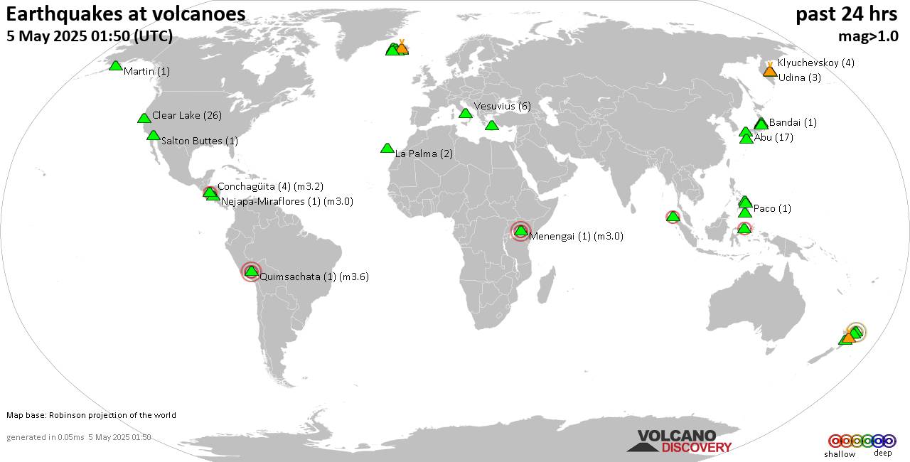
World map showing volcanoes with shallow (less than 50 km) earthquakes within 20 km radius during the past 24 hours on 5 May 2025 Number in brackets indicate nr of quakes.

Quakes detected near: Abu (17 quakes between mag 0.4-1.3), Ambang (1 quake mag 2.3), Bandai (1 quake mag 1.3), Bardarbunga (15 quakes between mag 0.1-2.1), Cabalian (1 quake mag 1.6), Clear Lake (26 quakes between mag 0.2-1.8)
Conchagüita (4 quakes between mag 2.0-3.2), Fagradalsfjall (8 quakes between mag 0.0-1.0), Hiuchi (6 quakes between mag 0.2-1.7), Kirishima (3 quakes between mag 0.3-1.3), Klyuchevskoy (4 quakes between mag 1.2-1.9), Kolumbo (24 quakes between mag 0.7-2.5), Krísuvík (5 quakes between mag 0.2-1.2), La Palma (2 quakes between mag 1.0-1.6), Ljósufjöll (22 quakes between mag 0.1-3.1), Loki-Fögrufjöll volcano (3 quakes between mag 0.5-1.0), Martin (1 quake mag 1.4), Menengai (1 quake mag 3.0), Nantai (1 quake mag 1.2), Nejapa-Miraflores (1 quake mag 3.0), Paco (1 quake mag 1.7), Parker (1 quake mag 1.5), Peuet Sague (1 quake mag 2.1), Prestahnukur (2 quakes between mag 1.3-1.4), Quimsachata (1 quake mag 3.6), Reporoa (5 quakes between mag 1.5-1.9), Rumble II West (1 quake mag 3.5), Rumble IV (1 quake mag 3.8), Salton Buttes (1 quake mag 1.6), Takahara (2 quakes between mag 0.3-1.0), Thordarhyrna (1 quake mag 1.4), Udina (3 quakes

Click this link to continue reading the article on the source website.

RSS feed source: Volcano Discovery.com--Global earthquake monitor

Mon, 5 May 2025, 00:24 | BY: EARTHQUAKEMONITOR

Worldwide earthquakes above magnitude 3 during the past 24 hours on 5 May 2025

Summary: 6 quakes 5.0+, 49 quakes 4.0+, 197 quakes 3.0+, 348 quakes 2.0+ (600 total)
Magnitude 5+: 6 earthquakes
Magnitude 4+: 49 earthquakes
Magnitude 3+: 197 earthquakes
Magnitude 2+: 348 earthquakes
No quakes of magnitude 6 or higherTotal seismic energy estimate: 5.4 x 10¹³ joules (15 gigawatt hours, equivalent to 12909 tons of TNT or 0.8 atomic bombs!) | equivalent to ONE quake of magnitude 6.0 learn more10 largest earthquakes in the world (4 May 2025)#1: Mag 5.6 70 km northeast of Road Town, British Virgin IslandsSunday, May 4, 2025, at 02:58 am (GMT -4) – #2: Mag 5.4 Culberson County, Texas, 55 mi south of Carlsbad, Eddy County, New Mexico, United StatesSaturday, May 3, 2025, at 07:47 pm (Chicago time) – #3: Mag 5.3 South Atlantic Ocean, 283 km southeast of Isla Phillips Island, Region de Magallanes y Antartica Chilena, ChileSunday, May 4, 2025, at 01:38 am (GMT -3) – #4: Mag 5.1 Solomon Sea, 61 km south of Guadalcanal Island, Solomon IslandsSunday, May 4, 2025, at 10:50 pm (GMT +11) – #5: Mag 5.1 South Atlantic Ocean, 321 km southeast of Isla Phillips Island, Region de Magallanes y Antartica Chilena, ChileSaturday, May 3, 2025, at 11:53 pm (GMT -5) – #6: Mag 5.1 North Pacific

Click this link to continue reading the article on the source website.

RSS feed source: Volcano Discovery.com--Global earthquake monitor

Date and TimeMag
DepthDistanceLocationDetailsMap May 5, 12:20 am (GMT +3)

3.2

17 km100 km (62 mi) to the E Aegean Sea, 26 km west of Nisyros Island, Dodecanese, South Aegean, GreeceI FELT IT

Info

May 4, 08:23 pm (GMT +3)

3.8

15 km6 km (3.7 mi) to the SW Aegean Sea, 25 km southwest of Amorgos Island, Cyclades, South Aegean, GreeceI FELT IT6 reportsInfoMay 2, 10:33 pm (GMT +3)

3.1

13 km69 km (43 mi) to the SW Aegean Sea, 31 km south of Santorini Island, Cyclades, South Aegean, GreeceI FELT IT1 report

Info

May 2, 08:58 pm (GMT +3)

3.5

15 km5 km (3.1 mi) to the S Aegean Sea, 25 km southwest of Amorgos Island, Cyclades, South Aegean, GreeceI FELT IT2 reportsInfoMay 2, 06:50 pm (GMT +3)

3.1

6.9 km9.2 km (5.7 mi) to the W Aegean Sea, 27 km southwest of Amorgos Island, Cyclades, South Aegean, GreeceI FELT IT

Info

Apr 20, 10:32 am (Athens)

4.3

14 km1.7 km (1.1 mi) to the W Aegean Sea, 21 km southwest of Amorgos Island, Cyclades, South Aegean, Greece 15 reportsInfoApr 13, 11:41 pm (Athens)

3.9

13 km3.9 km (2.4 mi) to the SE Aegean Sea, 22 km south of Amorgos Island, Cyclades, South Aegean, Greece 1 report

Info

Apr 13, 11:41 pm (Athens)

4.0

16 km35 km (21 mi) to the SE Aegean Sea, 25 km west of Astypalaia Island, Dodecanese, South Aegean, Greece InfoMar 27, 07:51 pm (Athens)

4.5

9.5 km19 km (12 mi) to the SW Aegean Sea, 25 km northwest of Anafi Island, Cyclades, South Aegean, Greece 12 reportsInfoMar

Click this link to continue reading the article on the source website.

RSS feed source: Volcano Discovery.com--Global earthquake monitor

Date and TimeMag
DepthDistanceLocationDetailsMap May 3, 06:58 am (GMT +9)

3.4

16 km48 km (30 mi) to the NE South Pacific Ocean, 34 km southeast of Pulau Ambai Island, Papua, IndonesiaI FELT IT

Info

Apr 24, 02:38 am (Jayapura)

3.0

10 km79 km (49 mi) to the SW Near N Coast of Papua, Indonesia

Info

Apr 18, 04:03 am (GMT +9)

3.7

10 km65 km (40 mi) to the W South Pacific Ocean, 52 km north of Pulau Nutorutomorya Island, Papua, Indonesia

Info

Mar 29, 06:25 am (Jayapura)

3.2

17 km73 km (45 mi) to the SE Kabupaten Waropen, South Papua, 155 km east of Nabire, Indonesia

Info

Mar 18, 01:29 am (GMT +9)

3.2

78 km85 km (53 mi) to the E Kabupaten Waropen, South Papua, 195 km northeast of Nabire, Indonesia

Info

Feb 14, 07:24 am (Jayapura)

4.2

21 km24 km (15 mi) to the S Kabupaten Waropen, South Papua, 117 km northeast of Nabire, Indonesia InfoFeb 14, 05:41 am (Jayapura)

4.2

25 km24 km (15 mi) to the S Kabupaten Waropen, South Papua, 118 km northeast of Nabire, Indonesia InfoFeb 14, 01:59 am (Jayapura)

3.9

24 km17 km (10.6 mi) to the S Kabupaten Waropen, South Papua, 121 km northeast of Nabire, Indonesia

Info

Jan 28, 10:27 am (Jayapura)

3.9

68 km79 km (49 mi) to the E Kabupaten Waropen, South Papua, 188 km northeast of Nabire, Indonesia

Info

Jan 14, 02:30 am (Jayapura)

3.9

12 km99 km (61 mi) to the E Mamberamo Raya Regency, South Papua, 213 km northeast of Nabire, Indonesia

Info

Jan 12, 2021 06:17 pm (Universal Time)

5.4

10 km83 km (52 mi) to the SE Puncak Regency, 143 km east of Nabire, Nabire Regency, Central Papua,

Click this link to continue reading the article on the source website.