RSS feed source: Volcano Discovery.com--Global earthquake monitor

5 km (3 mi)

N of epicenter

Salitre de Estopica

(pop: 202)

III: Weak

Chinicuila, Estado de Michoacan de Ocampo 6 km (4 mi)

SW of epicenter

Cobigenes

(pop: 85)

III: Weak

Aquila, Estado de Michoacan de Ocampo 13 km (8 mi)

W of epicenter

Santa Maria de Ostula

(pop: 972)

III: Weak

Aquila, Estado de Michoacan de Ocampo 13 km (8 mi)

E of epicenter

Cochumala

(pop: 69)

III: Weak

Coalcoman de Vazquez Pallares, Estado de Michoacan de Ocampo 16 km (10 mi)

NE of epicenter

La Changunguera

(pop: 16)

III: Weak

Coalcoman de Vazquez Pallares, Estado de Michoacan de Ocampo 17 km (10 mi)

SE of epicenter

Cuirla (La Changunguera de Cardenas)

(pop: 138)

III: Weak

Aquila, Estado de Michoacan de Ocampo 20 km (12 mi)

S of epicenter

Colola

(pop: 632)

III: Weak

Aquila, Estado de Michoacan de Ocampo 20 km (12 mi)

SW of epicenter

El Faro de Bucerias

(pop: 396)

III: Weak

Aquila, Estado de Michoacan de Ocampo 21 km (13 mi)

NW of epicenter

Aquila

(pop: 1,740)

III: Weak

Estado de Michoacan de Ocampo 23 km (14 mi)

N of epicenter

La Nuez (La Nuez del Caiman)

(pop: 71)

III: Weak

Chinicuila, Estado de Michoacan de Ocampo 25 km (15 mi)

E of epicenter

El Saucito

(pop: 107)

Click this link to continue reading the article on the source website.

RSS feed source: Volcano Discovery.com--Global earthquake monitor

Date and TimeMag
DepthDistanceLocationDetailsMap May 1, 08:45 am (GMT +9)

4.5

10 km16 km (9.9 mi) to the NE Philippine Sea, 288 km north of Tobelo, IndonesiaI FELT IT InfoMay 1, 08:38 am (GMT +9)

4.8

10 km18 km (10.9 mi) to the NE Philippine Sea, 181 km east of Pulau Kaburuang Island, Sulawesi Utara, IndonesiaI FELT IT InfoMay 1, 06:56 am (GMT +9)

4.3

5 km15 km (9.4 mi) to the NE Philippine Sea, 288 km north of Tobelo, IndonesiaI FELT IT InfoMay 1, 01:08 am (GMT +9)

4.4

64 km19 km (12 mi) to the NE Philippine Sea, 290 km north of Tobelo, IndonesiaI FELT IT InfoApr 22, 07:17 pm (GMT +9)

6.3

123 km70 km (43 mi) to the NW Philippine Sea, 121 km northeast of Pulau Kaburuang Island, Indonesia 24 reportsInfoDec 10, 2024 03:13 pm (GMT +9)

5.0

137 km68 km (42 mi) to the SW Philippine Sea, 116 km east of Pulau Kaburuang Island, Sulawesi Utara, Indonesia InfoJul 14, 2024 04:27 pm (GMT +9)

4.8

26 km40 km (25 mi) to the S Philippine Sea, 147 km east of Pulau Kaburuang Island, Sulawesi Utara, Indonesia InfoJun 23, 2024 01:50 pm (GMT +9)

5.0

84 km74 km (46 mi) to the NW Philippine Sea, 140 km northeast of Pulau Kaburuang Island, Indonesia InfoSep 26, 2023 09:39 am (GMT +8)

5.9

94 km95 km (59 mi) to the NW Philippine Sea, 129 km northeast of Pulau Kaburuang Island, Indonesia 1 reportInfoJan 18, 2023 03:06 pm (Jayapura)

7.1

64 km200 km (124 mi) to the SW Maluku Sea, 116 km south of Pulau Kaburuang Island, Sulawesi Utara,

Click this link to continue reading the article on the source website.

RSS feed source: Volcano Discovery.com--Global earthquake monitor

Date and TimeMag
DepthDistanceLocationDetailsMap Mar 5, 02:36 am (Lima)

4.5

162 km91 km (57 mi) to the SE 42 km north of Pucallpa, Ucayali, Peru InfoSep 1, 2024 04:21 pm (Lima)

4.0

12 km91 km (57 mi) to the NE Loreto, 175 km north of Pucallpa, Ucayali, Peru InfoAug 26, 2024 10:24 pm (Lima)

4.4

155 km61 km (38 mi) to the E 65 km east of Contamana, Loreto, Peru InfoAug 11, 2024 03:11 am (Lima)

4.0

134 km30 km (19 mi) to the SE 33 km southeast of Contamana, Loreto, Peru InfoJun 20, 2024 01:33 am (Lima)

4.2

110 km84 km (52 mi) to the SW 80 km southwest of Contamana, Loreto, Peru InfoMay 24, 2024 04:59 am (Lima)

5.2

22 km86 km (54 mi) to the SW 83 km southwest of Contamana, Loreto, Peru 3 reportsInfoMar 27, 2024 11:05 pm (Lima)

5.2

153 km91 km (57 mi) to the SE 55 km north of Pucallpa, Ucayali, Peru 6 reportsInfoMay 28, 2023 11:57 pm (Lima)

5.1

154 km88 km (55 mi) to the SE 43 km north of Pucallpa, Ucayali, Peru 4 reportsInfoDec 22, 2022 08:13 am (Lima)

5.5

156 km96 km (60 mi) to the SE 47 km north of Pucallpa, Ucayali, Peru 3 reportsInfoFeb 17, 2020 01:53 pm (Lima)

5.0

165 km43 km (27 mi) to the SE 42 Km Al Sur-Este De Contamana, Ucayali – Loreto (Peru) InfoNov 10, 2019 11:14 am (Lima)

4.9

107 km92 km (57 mi) to the W Northern Peru 1 reportInfoMay 26, 2019 02:41 am (Lima)

7.9

103 km173 km (107 mi) to the N 86 km southeast of Lagunas, Loreto, Peru 772 reportsInfoSep 13, 2018 11:12 pm (Lima)

5.0

151 km57 km (36 mi) to the SE 59

Click this link to continue reading the article on the source website.
RSS feed source: Volcano Discovery.com--Global earthquake monitor

Wed, 30 Apr 2025, 23:50 | BY: EARTHQUAKEMONITOR

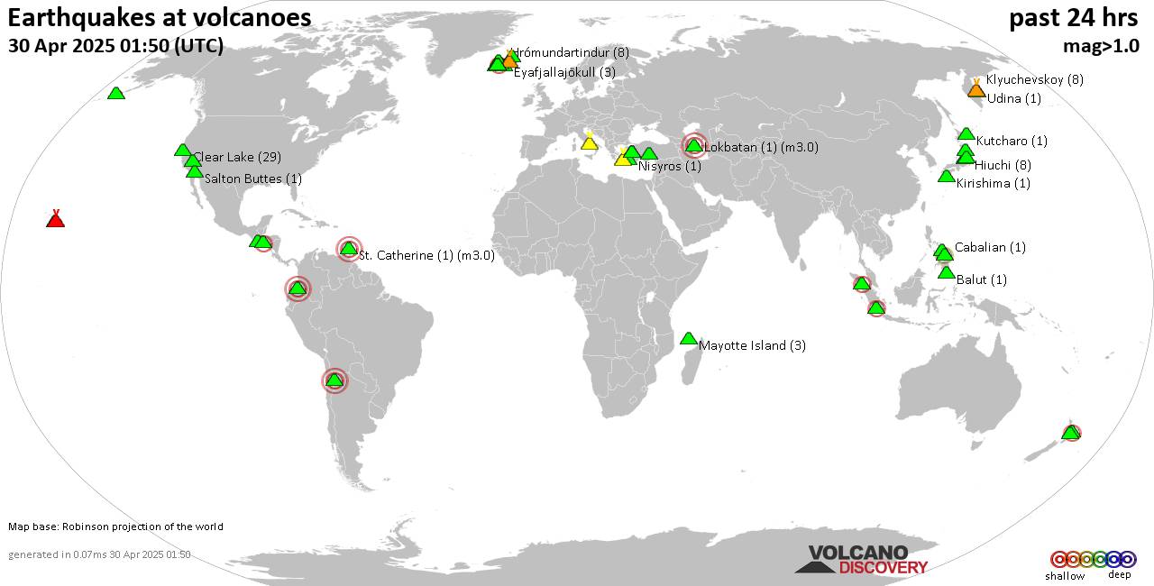
World map showing volcanoes with shallow (less than 50 km) earthquakes within 20 km radius during the past 24 hours on 30 Apr 2025 Number in brackets indicate nr of quakes.

Quakes detected near: Abu (43 quakes between mag 0.1-1.2), Akita-Komagatake (1 quake mag 1.6), Askja (3 quakes between mag 0.6-1.6), Bardarbunga (14 quakes between mag 0.3-1.7), Barva (1 quake mag 1.1), Biliran (1 quake mag 2.5)
Cabalian (1 quake mag 2.7), Campi Flegrei (Phlegrean Fields) (4 quakes between mag 0.1-1.0), Clear Lake (18 quakes between mag 0.3-2.2), Cuernos de Negros (2 quakes between mag 2.6-3.2), Eldey (2 quakes between mag 1.0-1.1), Fagradalsfjall (2 quakes between mag 0.9-1.1), Gagak (1 quake mag 2.2), Grímsvötn (2 quakes between mag 1.0-1.8), Hiuchi (10 quakes between mag 0.1-1.0), Hrómundartindur (4 quakes between mag 0.3-2.1), Kilauea (1 quake mag 1.9), Kirishima (2 quakes between mag 0.1-1.6), Klyuchevskoy (3 quakes between mag 0.8-1.5), Kolumbo (13 quakes between mag 1.6-2.3), Koryaksky (1 quake mag 2.2), Kurikoma (2 quakes between mag 0.8-1.4), Ljósufjöll (4 quakes between mag 1.2-2.6), Lokbatan (1 quake mag 3.0), Loki-Fögrufjöll volcano (2 quakes between mag 1.0-1.3), Long Valley (1 quake mag 1.4), Maunaloa (2 quakes between mag 1.5-1.9), Milos (1 quake mag 2.2), Nasu (1 quake mag 1.2), Nii-jima (1 quake mag 1.1), Nisyros (1 quake mag 1.8), Papandayan

Click this link to continue reading the article on the source website.