RSS feed source: Volcano Discovery.com--Global earthquake monitor

Wed, 30 Apr 2025, 13:50 | BY: EARTHQUAKEMONITOR

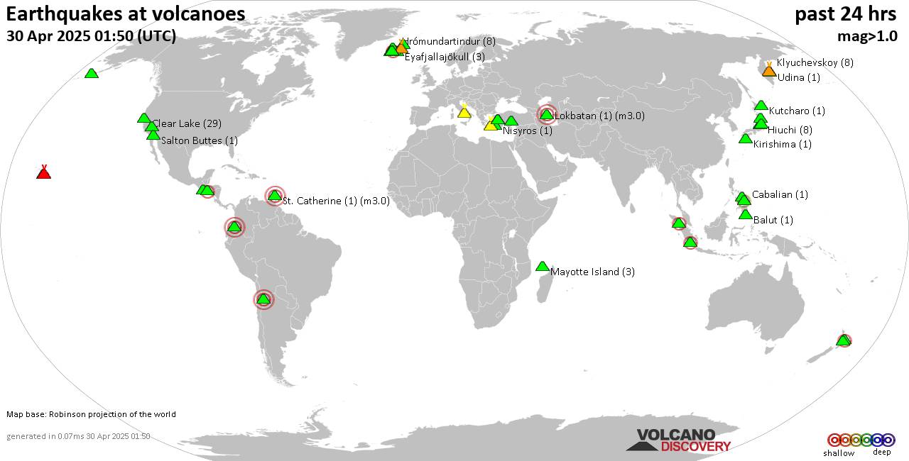
World map showing volcanoes with shallow (less than 50 km) earthquakes within 20 km radius during the past 24 hours on 30 Apr 2025 Number in brackets indicate nr of quakes.

Quakes detected near: Abu (39 quakes between mag 0.1-1.2), Akita-Komagatake (1 quake mag 1.6), Aracar (1 quake mag 3.0), Bardarbunga (12 quakes between mag 0.3-2.0), Biliran (1 quake mag 2.5), Cabalian (2 quakes between mag 2.0-2.7)
Campi Flegrei (Phlegrean Fields) (10 quakes between mag 0.1-1.4), Clear Lake (22 quakes between mag 0.2-1.8), Comondu-La Purisima (1 quake mag 1.9), Coso (2 quakes between mag 1.0-1.0), Eldey (3 quakes between mag 1.0-1.2), Fagradalsfjall (6 quakes between mag 0.2-1.1), Gagak (1 quake mag 2.2), Grímsvötn (3 quakes between mag 0.5-1.0), Hasan Dagi (1 quake mag 1.0), Hiuchi (10 quakes between mag 0.1-1.0), Hrómundartindur (4 quakes between mag 0.3-2.1), Jan Mayen (1 quake mag 1.3), Kilauea (1 quake mag 1.9), Kirishima (3 quakes between mag 0.1-1.6), Klyuchevskoy (5 quakes between mag 1.0-2.0), Kolumbo (11 quakes between mag 0.0-2.1), Koryaksky (1 quake mag 2.2), Krísuvík (3 quakes between mag 0.4-1.4), Ljósufjöll (2 quakes between mag 0.8-1.1), Long Valley (2 quakes between mag 0.7-1.4), Maunaloa (1 quake mag 1.7), Mayotte Island (2 quakes between mag 1.1-1.3), Nasu (3 quakes between mag 0.7-1.2), Nii-jima (1 quake mag 1.1), Nisyros (1 quake mag

Click this link to continue reading the article on the source website.
RSS feed source: Volcano Discovery.com--Global earthquake monitor

Date and TimeMag
DepthDistanceLocationDetailsMap Apr 29, 05:11 pm (Port Moresby)

4.9

100 km100 km (62 mi) to the SW 61 km northwest of Lae, Morobe, Papua New GuineaI FELT IT2 reportsInfoApr 24, 09:44 pm (Port Moresby)

4.8

104 km89 km (55 mi) to the S 68 km northeast of Lae, Morobe, Papua New GuineaI FELT IT2 reportsInfoApr 22, 11:29 pm (Port Moresby)

5.7

225 km32 km (20 mi) to the W Bismarck Sea, 24 km southwest of Long Island, Madang Province, Papua New GuineaI FELT IT22 reportsInfoApr 18, 12:57 pm (Port Moresby)

4.5

62 km118 km (73 mi) to the SE Solomon Sea, 33 km north of Finschhafen, Morobe, Papua New Guinea InfoApr 12, 08:24 am (Port Moresby)

5.0

128 km80 km (50 mi) to the W 95 km ESE of Madang, Papua New Guinea 3 reportsInfoMar 16, 02:28 am (Port Moresby)

5.1

59 km79 km (49 mi) to the SE 94 km northeast of Lae, Morobe, Papua New Guinea InfoMar 14, 2023 10:49 am (Port Moresby)

6.3

213 km50 km (31 mi) to the W 118 km E of Madang, Papua New Guinea 39 reportsInfoSep 11, 2022 09:47 am (Port Moresby)

7.6

116 km124 km (77 mi) to the SW 72 km northwest of Lae, Morobe, Papua New Guinea 166 reportsInfoJul 17, 2020 12:50 pm (Port Moresby)

7.0

73 km267 km (166 mi) to the S 114 km NNW of Popondetta, Papua New Guinea 216 reportsInfoMay 7, 2019 07:19 am (Port Moresby)

7.0

133 km188 km (117 mi) to the SW Eastern New Guinea Reg., P.N.G. 37 reportsInfoNov 7, 2014 01:33 pm (Port

Click this link to continue reading the article on the source website.

RSS feed source: Volcano Discovery.com--Global earthquake monitor

Date and TimeMag
DepthDistanceLocationDetailsMap Apr 29, 09:23 am (GMT -6)

3.9

21 km9.9 km (6.1 mi) to the SW North Pacific Ocean, 147 km southwest of San Jose, Costa RicaI FELT IT

Info

Apr 29, 03:37 am (GMT -6)

3.5

27 km14 km (8.5 mi) to the W North Pacific Ocean, 149 km southwest of San Jose, Costa RicaI FELT IT

Info

Apr 28, 10:35 am (GMT -6)

3.7

30 km74 km (46 mi) to the NW North Pacific Ocean, 81 km southwest of Puntarenas, Costa RicaI FELT IT

Info

Apr 27, 05:11 pm (Costa Rica)

3.6

3 km56 km (34 mi) to the NW North Pacific Ocean, 66 km southwest of Puntarenas, Costa RicaI FELT IT

Info

Apr 27, 03:17 pm (GMT -6)

3.5

23 km12 km (7.4 mi) to the SW North Pacific Ocean, 148 km southwest of San Jose, Costa RicaI FELT IT

Info

Feb 26, 06:05 am (GMT -6)

4.2

20 km73 km (45 mi) to the N North Pacific Ocean, 39 km south of Puntarenas, Costa Rica 9 reportsInfoFeb 15, 03:20 pm (Costa Rica)

3.9

3 km80 km (50 mi) to the NW North Pacific Ocean, 58 km southwest of Puntarenas, Costa Rica 1 report

Info

Feb 9, 11:23 pm (Costa Rica)

3.9

15 km76 km (47 mi) to the NW Off Coast of Costa Rica

Info

Jan 18, 12:27 am (Costa Rica)

4.0

18 km63 km (39 mi) to the NE North Pacific Ocean, 75 km southwest of San Jose, Costa Rica 1 reportInfoMar 20, 2023 07:44 pm (Costa Rica)

5.5

35 km95 km (59 mi) to the NE North Pacific Ocean, 63 km south of San Jose, San Jose,

Click this link to continue reading the article on the source website.

RSS feed source: Volcano Discovery.com--Global earthquake monitor

91 km (57 mi)

N of epicenter

Pundong

(pop: 24,100)

II: Very weak

Kabupaten Bantul, Yogyakarta 91 km (57 mi)

N of epicenter

Bambanglipuro

(pop: 44,700)

II: Very weak

Kabupaten Bantul, Yogyakarta 93 km (58 mi)

N of epicenter

Srandakan

(pop: 29,500)

II: Very weak

Kabupaten Bantul, Yogyakarta 94 km (58 mi)

N of epicenter

Wonosari

(pop: 87,500)

II: Very weak

Kabupaten Gunung Kidul, Yogyakarta 95 km (59 mi)

N of epicenter

Pandak

(pop: 56,000)

II: Very weak

Kabupaten Bantul, Yogyakarta 98 km (61 mi)

N of epicenter

Bantul

(pop: 64,400)

II: Very weak

Yogyakarta 99 km (62 mi)

N of epicenter

Sewon

(pop: 73,600)

II: Very weak

Kabupaten Bantul, Yogyakarta 105 km (65 mi)

N of epicenter

Kasihan

(pop: 86,200)

II: Very weak

Kabupaten Bantul, Yogyakarta 108 km (67 mi)

N of epicenter

Yogyakarta

(pop: 373,600)

II: Very weak

Yogyakarta 108 km (67 mi)

N of epicenter

Gamping Lor

(pop: 66,100)

II: Very weak

Kabupaten Sleman, Yogyakarta 111 km (69 mi)

N of epicenter

Godean

(pop: 63,200)

II: Very weak

Kabupaten Sleman, Yogyakarta 112 km (70 mi)

N of epicenter

Depok

(pop: 104,500)

II: Very weak

Kabupaten Sleman, Yogyakarta 115 km (71 mi)

N of epicenter

Candi Prambanan

(pop: 44,900)

II: Very weak

Kabupaten Klaten, Central Java 115

Click this link to continue reading the article on the source website.