RSS feed source: Volcano Discovery.com--Global earthquake monitor

Date and TimeMag
DepthDistanceLocationDetailsMap Feb 13, 06:09 pm (GMT -6)

4.6

1 km76 km (47 mi) to the SW Caribbean Sea, 131 km northeast of Tocoa, Departamento de Colon, Honduras 1 reportInfoFeb 12, 03:52 pm (GMT -6)

4.7

1 km46 km (29 mi) to the W Caribbean Sea, 137 km northwest of Brus Laguna, Honduras 1 reportInfoFeb 12, 04:11 am (GMT -6)

3.2

5 km79 km (49 mi) to the W 114 km Al Noreste De Trujillo, Honduras

Info

Feb 8, 05:23 pm (GMT -6)

7.6

10 km242 km (151 mi) to the E Caribbean Sea, Honduras 371 reportsInfoFeb 1, 11:48 am (GMT -6)

4.9

10 km98 km (61 mi) to the W 69 km NNE of Savannah Bight, Honduras 5 reportsInfoDec 24, 2024 07:06 am (GMT -6)

4.1

9 km56 km (35 mi) to the NE Caribbean Sea, 317 km northeast of La Ceiba, Departamento de Atlantida, Honduras InfoDec 6, 2024 10:41 pm (GMT -6)

3.9

3 km92 km (57 mi) to the SW 94 Km al noroeste de Tusi, Honduras

Info

Dec 13, 2023 10:10 pm (GMT -6)

5.1

5 km59 km (37 mi) to the SE Caribbean Sea, 227 km east of Isla de Roatan Island, Honduras InfoAug 18, 2023 06:16 am (GMT -6)

5.3

0 km86 km (54 mi) to the NW Caribbean Sea, 200 km northeast of Roatan Island, Islas de la Bahia, Honduras InfoAug 17, 2023 03:11 pm (GMT -6)

4.7

10 km92 km (57 mi) to the W 70 km NE of Savannah Bight, Honduras InfoMar 28, 2022 12:43 pm (GMT -6)

5.4

10 km23 km (14 mi) to the N 152 km ENE of Savannah Bight, Honduras 9 reportsInfoDec 17, 2021 07:58

Click this link to continue reading the article on the source website.

RSS feed source: Volcano Discovery.com--Global earthquake monitor

54 km (34 mi)

N of epicenter

La Libertad

(pop: 16,900)

III: Weak

Departamento de La Libertad 66 km (41 mi)

N of epicenter

Zaragoza

(pop: 11,700)

III: Weak

Departamento de La Libertad 71 km (44 mi)

NE of epicenter

El Rosario

(pop: 5,620)

III: Weak

Departamento de La Paz 75 km (47 mi)

NW of epicenter

Acajutla

(pop: 22,800)

III: Weak

Sonsonate 75 km (47 mi)

N of epicenter

Antiguo Cuscatlan

(pop: 33,800)

III: Weak

Departamento de La Libertad 76 km (47 mi)

N of epicenter

Santa Tecla

(pop: 124,700)

III: Weak

Departamento de La Libertad 77 km (48 mi)

N of epicenter

San Marcos

(pop: 54,600)

III: Weak

Departamento de San Salvador 78 km (48 mi)

NE of epicenter

Santo Tomas

(pop: 14,600)

III: Weak

Departamento de San Salvador 80 km (50 mi)

N of epicenter

San Salvador

(pop: 526,000)

III: Weak

Departamento de San Salvador 81 km (50 mi)

N of epicenter

Armenia

(pop: 15,000)

III: Weak

Sonsonate 83 km (51 mi)

N of epicenter

Sonsonate

(pop: 59,500)

III: Weak

Sonsonate 83 km (52 mi)

NE of epicenter

Zacatecoluca

(pop: 39,600)

III: Weak

Departamento de La Paz 84 km (52 mi)

N of epicenter

Mejicanos

(pop: 160,300)

III: Weak

Departamento de San Salvador 84 km (52

Click this link to continue reading the article on the source website.

RSS feed source: Volcano Discovery.com--Global earthquake monitor

Date and TimeMag
DepthDistanceLocationDetailsMap Apr 25, 08:11 am (GMT -6)

4.8

63 km13 km (7.9 mi) to the N North Pacific Ocean, 68 km south of San Salvador, El SalvadorI FELT IT24 reportsInfoApr 17, 08:24 am (GMT -6)

4.2

27 km62 km (38 mi) to the E North Pacific Ocean, 77 km southwest of Usulutan, Usulutan, El Salvador InfoApr 10, 01:35 pm (GMT -6)

4.2

59 km44 km (28 mi) to the E North Pacific Ocean, 71 km south of San Salvador, El Salvador 3 reportsInfoMar 24, 02:05 am (El Salvador)

4.2

166 km89 km (56 mi) to the NE 19 km southeast of Zacatecoluca, Departamento de La Paz, El Salvador InfoMar 22, 03:51 pm (GMT -6)

4.0

46 km21 km (13 mi) to the NE North Pacific Ocean, 66 km south of San Salvador, El Salvador InfoMar 20, 03:07 pm (GMT -6)

4.4

22 km20 km (12 mi) to the W 56 km Al Suroeste De La Libertad, El Salvador InfoMar 20, 03:07 pm (GMT -6)

4.3

32 km19 km (12 mi) to the NW North Pacific Ocean, 77 km southwest of San Salvador, El Salvador InfoMar 20, 02:15 am (GMT -6)

5.0

56 km66 km (41 mi) to the E North Pacific Ocean, 92 km southeast of San Salvador, El Salvador 13 reportsInfoMar 18, 08:47 pm (El Salvador)

4.8

151 km83 km (52 mi) to the NE 5 km east of San Salvador, Departamento de San Salvador, El Salvador InfoJan 5, 11:18 am (GMT -6)

6.2

46 km31 km (19 mi) to the E North Pacific Ocean, 77 km south of San Salvador, El Salvador 188 reportsInfoAug 28,

Click this link to continue reading the article on the source website.
RSS feed source: Volcano Discovery.com--Global earthquake monitor

Mon, 28 Apr 2025, 15:50 | BY: EARTHQUAKEMONITOR

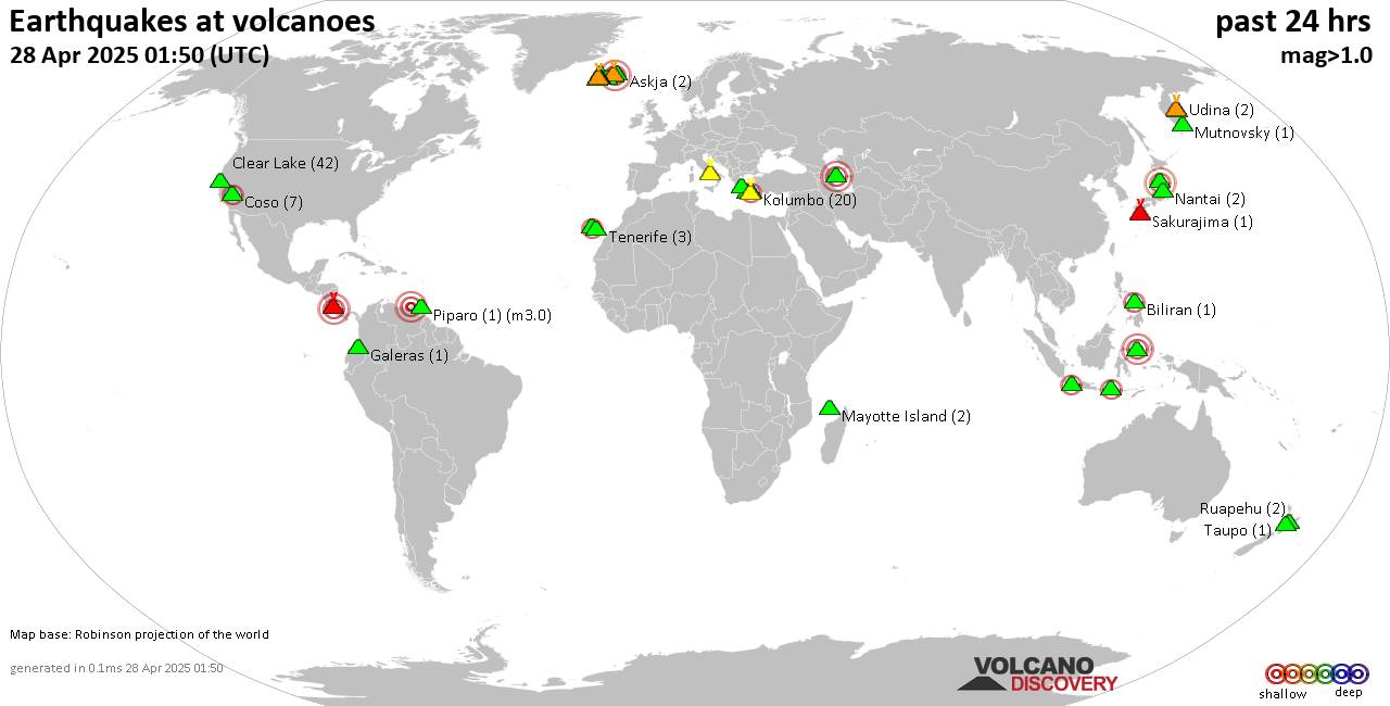
World map showing volcanoes with shallow (less than 50 km) earthquakes within 20 km radius during the past 24 hours on 28 Apr 2025 Number in brackets indicate nr of quakes.

Quakes detected near: Campi Flegrei (Phlegrean Fields) (15 quakes between mag 0.1-1.6), Chaîne des Puys (2 quakes between mag 1.1-2.3), Chokai (2 quakes between mag 3.0-3.1), Clear Lake (39 quakes between mag 0.4-1.9), Comondu-La Purisima (1 quake mag 2.3), Coso (6 quakes between mag 1.2-2.1)
Eldey (3 quakes between mag 1.4-2.2), Garibaldi (1 quake mag 3.0), Grímsvötn (3 quakes between mag 0.3-1.0), Haku-san (1 quake mag 1.1), Hiuchi (3 quakes between mag 0.7-1.5), Kilauea (1 quake mag 1.7), Kita Yatsugatake (1 quake mag 1.1), Klyuchevskoy (8 quakes between mag 1.1-1.8), Kolumbo (13 quakes between mag 1.1-2.1), Kukak (1 quake mag 1.4), La Palma (2 quakes between mag 2.1-2.1), Ljósufjöll (9 quakes between mag 0.5-2.3), Mayotte Island (3 quakes between mag 1.0-1.5), Methana (1 quake mag 3.8), Milos (1 quake mag 1.9), Mutnovsky (1 quake mag 1.1), Paco (1 quake mag 2.3), Platanar (1 quake mag 1.1), Reporoa (1 quake mag 1.6), San Cristobal (1 quake mag 1.6), Santorini (1 quake mag 1.2), Sousaki (1 quake mag 2.9), Svartsengi (20 quakes between mag 0.0-1.1), Tambora (1 quake mag 2.3), Taranaki (1 quake mag 1.3), Turrialba (1

Click this link to continue reading the article on the source website.