RSS feed source: Volcano Discovery.com--Global earthquake monitor

Mon, 5 May 2025, 09:50 | BY: EARTHQUAKEMONITOR

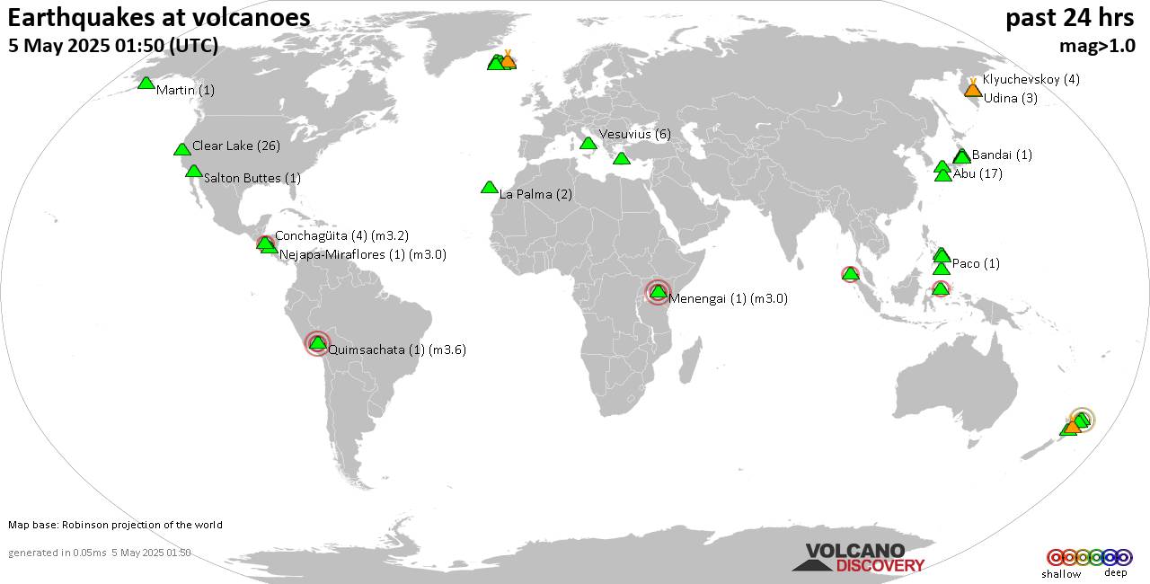
World map showing volcanoes with shallow (less than 50 km) earthquakes within 20 km radius during the past 24 hours on 5 May 2025 Number in brackets indicate nr of quakes.

Quakes detected near: Abu (18 quakes between mag 0.1-1.0), Ambang (1 quake mag 2.3), Askja (1 quake mag 1.3), Bandai (1 quake mag 1.3), Bardarbunga (11 quakes between mag 0.5-3.0), Cabalian (1 quake mag 1.6)
Clear Lake (26 quakes between mag 0.2-1.8), Conchagüita (4 quakes between mag 2.0-3.2), Cosigüina (1 quake mag 2.5), Coso (2 quakes between mag 1.2-1.3), Fagradalsfjall (5 quakes between mag 0.0-1.0), Golden Trout Creek (1 quake mag 3.0), Guagua Pichincha (1 quake mag 3.0), Hiuchi (4 quakes between mag 0.2-1.1), Iya (1 quake mag 2.4), Kirishima (4 quakes between mag 0.3-1.3), Klyuchevskoy (4 quakes between mag 1.2-1.9), Kolumbo (15 quakes between mag 0.7-2.5), Krísuvík (5 quakes between mag 0.2-1.2), Ljósufjöll (18 quakes between mag 0.1-3.1), Los Atlixcos (1 quake mag 3.2), Martin (1 quake mag 1.4), Miravalles (1 quake mag 2.4), Parker (1 quake mag 1.5), Peuet Sague (1 quake mag 2.1), Prestahnukur (2 quakes between mag 1.3-1.4), Quimsachata (1 quake mag 3.6), Reporoa (11 quakes between mag 1.5-2.2), Rinjani (1 quake mag 3.1), Rumble IV (1 quake mag 3.8), Takahara (2 quakes between mag 0.1-1.0), Tjörnes Fracture Zone (3 quakes

Click this link to continue reading the article on the source website.
RSS feed source: Volcano Discovery.com--Global earthquake monitor

Date and TimeMag
DepthDistanceLocationDetailsMap May 2, 11:24 am (Santiago)

4.8

27 km55 km (34 mi) to the N South Pacific Ocean, Region de Atacama, 108 km northwest of La Serena, Provincia de Elqui, Region de Coquimbo, ChileI FELT IT1 reportInfoMay 2, 03:08 am (Santiago)

4.4

45 km40 km (25 mi) to the E South Pacific Ocean, 36 km north of La Serena, Provincia de Elqui, Region de Coquimbo, ChileI FELT IT6 reportsInfoApr 12, 08:09 am (GMT -4)

4.6

10 km33 km (21 mi) to the SW South Pacific Ocean, 84 km west of La Serena, Provincia de Elqui, Region de Coquimbo, Chile InfoApr 3, 12:46 am (Santiago)

4.1

62 km47 km (29 mi) to the SE South Pacific Ocean, 30 km west of La Serena, Provincia de Elqui, Region de Coquimbo, Chile 4 reportsInfoMar 24, 01:35 am (Santiago)

5.2

85 km59 km (36 mi) to the E 24 km north of La Serena, Provincia de Elqui, Region de Coquimbo, Chile 32 reportsInfoDec 30, 2024 01:41 am (GMT -4)

5.5

10 km53 km (33 mi) to the SW South Pacific Ocean, 72 km west of La Serena, Provincia de Elqui, Region de Coquimbo, Chile 28 reportsInfoSep 22, 2024 10:36 pm (Santiago)

5.4

61 km61 km (38 mi) to the SE 23 km north of La Serena, Provincia de Elqui, Region de Coquimbo, Chile 47 reportsInfoFeb 13, 2024 09:31 pm (Santiago)

5.8

28 km75 km (46 mi) to the NE 73 km southwest of Vallenar, Huasco, Region de Atacama, Chile 27 reportsInfoJan 22, 2024 06:30 pm (GMT -4)

5.4

10 km88 km (55 mi)

Click this link to continue reading the article on the source website.

RSS feed source: Volcano Discovery.com--Global earthquake monitor

Date and TimeMag
DepthDistanceLocationDetailsMap Apr 28, 09:54 pm (GMT -5)

3.1

66 km53 km (33 mi) to the NW South Pacific Ocean, Provincia del Guayas, EcuadorI FELT IT

Info

Apr 28, 07:04 am (Guayaquil)

3.5

59 km94 km (58 mi) to the W Provincia de Santa Elena, 43 km west of Guayaquil, Provincia del Guayas, EcuadorI FELT IT

Info

Apr 25, 07:09 am (Guayaquil)

4.1

85 km55 km (34 mi) to the NW 28 km north of Guayaquil, Provincia del Guayas, Ecuador 2 reportsInfoApr 18, 08:57 pm (GMT -5)

3.5

88 km35 km (22 mi) to the SE Ecuador – Canar

Info

Apr 16, 11:19 am (GMT -5)

3.4

6 km49 km (31 mi) to the SW 38 km south of Guayaquil, Provincia del Guayas, Ecuador

Info

Jan 21, 06:29 am (Guayaquil)

4.2

54 km96 km (60 mi) to the SW 9.8 km north of Posorja, Provincia del Guayas, Ecuador InfoJan 13, 09:20 pm (Guayaquil)

5.3

50 km30 km (19 mi) to the NW 7.9 km west of Milagro, Provincia del Guayas, Ecuador InfoJan 12, 09:20 pm (Guayaquil)

5.0

91 km36 km (22 mi) to the W 17 km southeast of Guayaquil, Provincia del Guayas, Ecuador 167 reportsInfoDec 14, 2024 08:35 am (Guayaquil)

4.1

68 km41 km (25 mi) to the W 22 km southeast of Guayaquil, Provincia del Guayas, Ecuador InfoMay 7, 2023 07:51 pm (Guayaquil)

5.2

90 km75 km (47 mi) to the SE 8 km W of Azogues, Ecuador 86 reportsInfoApr 25, 2023 12:36 am (Guayaquil)

5.2

69 km74 km (46 mi) to the SW South Pacific Ocean, 31 km east of Isla Puna Island, Ecuador 37 reportsInfoMar 18, 2023 12:12 pm (Guayaquil)

6.8

68 km71 km (44 mi) to the SW

Click this link to continue reading the article on the source website.

RSS feed source: Volcano Discovery.com--Global earthquake monitor

Mon, 5 May 2025, 08:37 | BY: EARTHQUAKEMONITOR

An earthquake of magnitude 5.7 occurred early morning on Monday, May 5th, 2025, at 2:28 am local time near San Cristobal de las Casas, San Cristobal De Casas, Estado de Chiapas, Mexico, as reported by the European-Mediterranean Seismological Centre (EMSC).
According to preliminary data, the quake was located at an intermediate to considerable depth of 262. km. The strength of the earthquake may have been tempered by its relative great depth below the surface, which makes it feel weaker in absolute terms. The exact magnitude, epicenter, and depth of the quake might be revised within the next few hours or minutes as seismologists review data and refine their calculations, or as other agencies issue their report.
Our monitoring service identified a second report from The Colombian Geological Service (SGC) which listed the quake at magnitude 5.6. Other agencies reporting the same quake include France’s Réseau National de Surveillance Sismique (RéNaSS) at magnitude 5.2, the citizen-seismograph network of RaspberryShake at magnitude 5.8, and the German Research Centre for Geosciences (GFZ) at magnitude 5.8.
Based on the preliminary seismic data, the quake should not have caused any significant damage, but was probably felt by many people as light vibration in the area of the epicenter.
Weak shaking might have been felt in Teopisca (pop. 16,200) located 9 km from

Click this link to continue reading the article on the source website.