RSS feed source: Volcano Discovery.com--Global earthquake monitor

54 km (34 mi)

N of epicenter

La Libertad

(pop: 16,900)

III: Weak

Departamento de La Libertad 66 km (41 mi)

N of epicenter

Zaragoza

(pop: 11,700)

III: Weak

Departamento de La Libertad 71 km (44 mi)

NE of epicenter

El Rosario

(pop: 5,620)

III: Weak

Departamento de La Paz 75 km (47 mi)

NW of epicenter

Acajutla

(pop: 22,800)

III: Weak

Sonsonate 75 km (47 mi)

N of epicenter

Antiguo Cuscatlan

(pop: 33,800)

III: Weak

Departamento de La Libertad 76 km (47 mi)

N of epicenter

Santa Tecla

(pop: 124,700)

III: Weak

Departamento de La Libertad 77 km (48 mi)

N of epicenter

San Marcos

(pop: 54,600)

III: Weak

Departamento de San Salvador 78 km (48 mi)

NE of epicenter

Santo Tomas

(pop: 14,600)

III: Weak

Departamento de San Salvador 80 km (50 mi)

N of epicenter

San Salvador

(pop: 526,000)

III: Weak

Departamento de San Salvador 81 km (50 mi)

N of epicenter

Armenia

(pop: 15,000)

III: Weak

Sonsonate 83 km (51 mi)

N of epicenter

Sonsonate

(pop: 59,500)

III: Weak

Sonsonate 83 km (52 mi)

NE of epicenter

Zacatecoluca

(pop: 39,600)

III: Weak

Departamento de La Paz 84 km (52 mi)

N of epicenter

Mejicanos

(pop: 160,300)

III: Weak

Departamento de San Salvador 84 km (52

Click this link to continue reading the article on the source website.

RSS feed source: Volcano Discovery.com--Global earthquake monitor

Mon, 28 Apr 2025, 15:50 | BY: EARTHQUAKEMONITOR

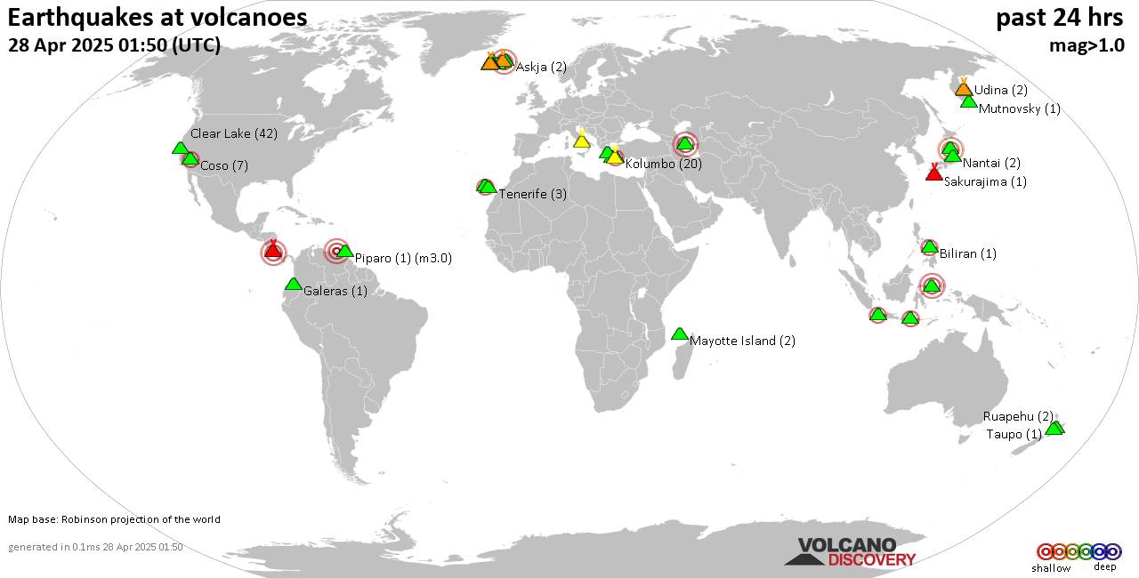
World map showing volcanoes with shallow (less than 50 km) earthquakes within 20 km radius during the past 24 hours on 28 Apr 2025 Number in brackets indicate nr of quakes.

Quakes detected near: Campi Flegrei (Phlegrean Fields) (15 quakes between mag 0.1-1.6), Chaîne des Puys (2 quakes between mag 1.1-2.3), Chokai (2 quakes between mag 3.0-3.1), Clear Lake (39 quakes between mag 0.4-1.9), Comondu-La Purisima (1 quake mag 2.3), Coso (6 quakes between mag 1.2-2.1)
Eldey (3 quakes between mag 1.4-2.2), Garibaldi (1 quake mag 3.0), Grímsvötn (3 quakes between mag 0.3-1.0), Haku-san (1 quake mag 1.1), Hiuchi (3 quakes between mag 0.7-1.5), Kilauea (1 quake mag 1.7), Kita Yatsugatake (1 quake mag 1.1), Klyuchevskoy (8 quakes between mag 1.1-1.8), Kolumbo (13 quakes between mag 1.1-2.1), Kukak (1 quake mag 1.4), La Palma (2 quakes between mag 2.1-2.1), Ljósufjöll (9 quakes between mag 0.5-2.3), Mayotte Island (3 quakes between mag 1.0-1.5), Methana (1 quake mag 3.8), Milos (1 quake mag 1.9), Mutnovsky (1 quake mag 1.1), Paco (1 quake mag 2.3), Platanar (1 quake mag 1.1), Reporoa (1 quake mag 1.6), San Cristobal (1 quake mag 1.6), Santorini (1 quake mag 1.2), Sousaki (1 quake mag 2.9), Svartsengi (20 quakes between mag 0.0-1.1), Tambora (1 quake mag 2.3), Taranaki (1 quake mag 1.3), Turrialba (1

Click this link to continue reading the article on the source website.
RSS feed source: Volcano Discovery.com--Global earthquake monitor

Date and TimeMag
DepthDistanceLocationDetailsMap Mar 22, 01:27 pm (GMT +8)

4.7

18 km90 km (56 mi) to the W 73 km E of Kinablangan, Philippines InfoMar 13, 03:40 am (GMT +8)

4.2

10 km88 km (55 mi) to the NW Philippine Sea, 119 km east of Bislig, Surigao del Sur, Caraga, Philippines InfoMar 13, 12:09 am (GMT +9)

5.7

10 km79 km (49 mi) to the NW 130 km E of Barcelona, Philippines 4 reportsInfoJan 1, 06:32 am (GMT +8)

4.6

10 km87 km (54 mi) to the W 86 km ENE of Kinablangan, Philippines InfoDec 27, 2024 09:57 am (GMT +8)

4.7

18 km100 km (62 mi) to the W76 km ENE of Kinablangan, Philippines InfoAug 19, 2024 11:32 pm (GMT +8)

4.9

10 km98 km (61 mi) to the W 76 km ENE of Kinablangan, Philippines InfoApr 26, 2024 12:20 am (GMT +8)

5.0

18 km73 km (45 mi) to the W 090 km N 82° E of Baganga (Davao Oriental) 1 reportInfoJan 29, 2024 03:37 pm (GMT +8)

5.1

10 km97 km (60 mi) to the NW Philippine Islands Region 1 reportInfoDec 2, 2023 10:37 pm (Manila)

7.6

40 km194 km (120 mi) to the NW Philippine Sea, 36 km north of Bislig, Surigao del Sur, Caraga, Philippines 565 reportsInfoAug 11, 2021 05:46 pm (GMT +0)

7.0

63 km205 km (128 mi) to the SW Philippine Sea, 74 km southeast of Mati, Davao Oriental, Davao, Philippines 617 reportsInfoMay 6, 2020 11:53 am (GMT +9)

5.0

11 km92 km (57 mi) to the SW Philippine Sea, 121 km southeast of Daquit Island, Philippines InfoJun 1, 2014 04:54 am (GMT +9)

5.3

333 km50 km (31 mi) to the E Philippine Sea,

Click this link to continue reading the article on the source website.

RSS feed source: Volcano Discovery.com--Global earthquake monitor

Date and TimeMag
DepthDistanceLocationDetailsMap Apr 15, 08:42 pm (GMT +11)

4.4

40 km131 km (81 mi) to the SE 81 km ESE of Shikotan, Russia InfoApr 15, 06:42 pm (GMT +9)

4.8

30 km116 km (72 mi) to the S Russia: E Off Hokkaido InfoApr 2, 07:04 am (GMT +9)

4.1

58 km126 km (78 mi) to the S42 km SW of Shikotan, Russia InfoMar 30, 12:00 am (GMT +11)

4.3

162 km75 km (46 mi) to the SW Kurilsky District, 33 km northeast of Yuzhno-Kurilsk, Yuzhno-Kurilsky District, Sakhalin Oblast, Russia InfoMar 14, 05:53 am (GMT +11)

4.6

65 km116 km (72 mi) to the S North Pacific Ocean, 39 km southeast of Shikotan, Sakhalin Oblast, Russia InfoOct 24, 2016 06:25 am (GMT +10)

5.8

24 km111 km (69 mi) to the SE Kuril Islands InfoJul 7, 2015 03:10 pm (GMT +10)

6.2

53 km112 km (70 mi) to the SE North Pacific Ocean, 171 km east of Yuzhno-Kurilsk, Yuzhno-Kurilsky District, Sakhalin Oblast, Russia InfoMar 11, 2007 05:09 pm (GMT +10)

5.8

52 km101 km (63 mi) to the SE North Pacific Ocean, 96 km east of Shikotan, Sakhalin Oblast, Russia InfoSep 21, 2005 01:25 pm (GMT +11)

6.1

103 km97 km (61 mi) to the SW Sea of Okhotsk, 27 km southeast of Yuzhno-Kurilsk, Yuzhno-Kurilsky District, Sakhalin Oblast, Russia InfoNov 29, 2004 03:32 am (GMT +9)

7.0

39 km226 km (141 mi) to the SW North Pacific Ocean, 61 km east of Kushiro, Hokkaido, Japan InfoNov 4, 2004 11:03 pm (GMT +9)

5.9

62 km106 km (66 mi) to the S North Pacific Ocean, 20 km south of Shikotan Island, Yuzhno-Kurilsky District, Sakhalin Oblast, Russia InfoOct 29,

Click this link to continue reading the article on the source website.