RSS feed source: Volcano Discovery.com--Global earthquake monitor

Wed, 30 Apr 2025, 02:19 | BY: EARTHQUAKEMONITOR

An intermediate magnitude 3.7 earthquake was reported early evening near Anchor Point, Kenai Peninsula, Alaska, USA.
According to the United States Geological Survey, the quake hit on Tuesday, April 29th, 2025, at 6:14 pm local time at an intermediate depth of 68 miles. The strength of the earthquake may have been tempered by its relative great depth below the surface, which makes it feel weaker in absolute terms. The exact magnitude, epicenter, and depth of the quake might be revised within the next few hours or minutes as seismologists review data and refine their calculations, or as other agencies issue their report.
Our monitoring service identified a second report from The Incorporated Research Institutions for Seismology (IRIS) which listed the quake at magnitude 3.7 as well. A third agency, the European-Mediterranean Seismological Centre (EMSC), reported the same quake at magnitude 3.7.
According to preliminary calculations, we do not expect that the quake was felt by many people and did not cause any damage. In Ninilchik (pop. 880, 35 miles away), Anchor Point (pop. 1,900, 42 miles away), Cohoe (pop. 1,400, 45 miles away), Kalifornsky (pop. 7,900, 46 miles away), Kenai (pop. 7,700, 50 miles away), Nikiski (pop. 4,500, 54 miles away), Soldotna (pop. 4,500, 55 miles away), and Homer (pop. 5,500, 56 miles away), the quake was

Click this link to continue reading the article on the source website.

RSS feed source: Volcano Discovery.com--Global earthquake monitor

Wed, 30 Apr 2025, 00:50 | BY: EARTHQUAKEMONITOR

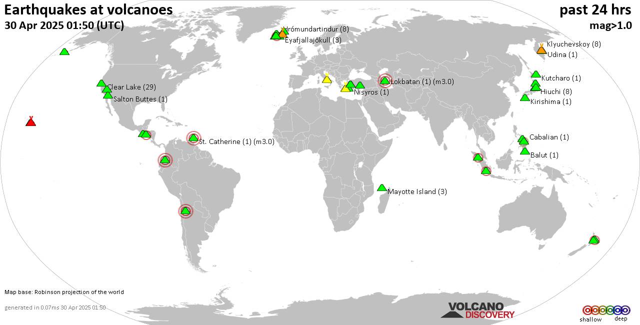
World map showing volcanoes with shallow (less than 50 km) earthquakes within 20 km radius during the past 24 hours on 30 Apr 2025 Number in brackets indicate nr of quakes.

Quakes detected near: Apastepeque (2 quakes between mag 2.6-2.6), Aracar (2 quakes between mag 3.0-3.0), Balut (1 quake mag 1.6), Bardarbunga (10 quakes between mag 0.2-1.3), Biliran (1 quake mag 1.5), Cabalian (1 quake mag 2.0)
Campi Flegrei (Phlegrean Fields) (9 quakes between mag 0.1-1.4), Clear Lake (29 quakes between mag 0.2-1.6), Colima (1 quake mag 2.9), Coso (1 quake mag 1.0), Eldey (2 quakes between mag 1.2-1.3), Eyafjallajökull (3 quakes between mag 0.6-1.5), Fagradalsfjall (30 quakes between mag 0.0-1.0), Galeras (1 quake mag 3.0), Hasan Dagi (1 quake mag 1.0), Hiuchi (8 quakes between mag 0.4-1.1), Hrómundartindur (8 quakes between mag 0.1-1.1), Kenger (1 quake mag 1.1), Kilauea (4 quakes between mag 1.7-1.9), Kirishima (1 quake mag 1.0), Klyuchevskoy (5 quakes between mag 1.1-1.9), Kolumbo (12 quakes between mag 1.6-2.1), Krísuvík (31 quakes between mag 0.1-2.3), Kurikoma (2 quakes between mag 0.7-1.1), Kutcharo (1 quake mag 1.2), Ljósufjöll (7 quakes between mag 0.6-2.4), Lokbatan (1 quake mag 3.0), Loki-Fögrufjöll volcano (2 quakes between mag 0.8-1.0), Maunaloa (2 quakes between mag 1.7-1.8), Mayotte Island (3 quakes between mag 1.2-1.3), Nasu (2 quakes between mag 0.7-1.0),

Click this link to continue reading the article on the source website.
RSS feed source: Volcano Discovery.com--Global earthquake monitor

Wed, 30 Apr 2025, 01:19 | BY: EARTHQUAKEMONITOR

Just 38 minutes ago, a 4.8-magnitude earthquake struck near Gueiria, Valdez Municipality, Sucre, Venezuela. The tremor was recorded in the evening on Tuesday, April 29th, 2025, at 8:39 pm local time, at an intermediate depth of 131.61 km below the surface.
The event was filed by the United States Geological Survey, the first seismological agency to report it.
Our monitoring service identified a second report from The Colombian Geological Service (SGC) which listed the quake at magnitude 4.8 as well. Other agencies reporting the same quake include the German Research Centre for Geosciences (GFZ) at magnitude 4.7, The Incorporated Research Institutions for Seismology (IRIS) at magnitude 4.8, and the European-Mediterranean Seismological Centre (EMSC) at magnitude 4.8.
Towns or cities near the epicenter where the quake might have been felt as very weak shaking include Gueiria (pop. 40,000) located 83 km from the epicenter, Saint George’s (pop. 7,500) 98 km away, and Port of Spain (pop. 49,000) 109 km away.
VolcanoDiscovery will automatically update magnitude and depth if these change and follow up if other significant news about the quake become available. If you’re in the area, please send us your experience through our reporting mechanism, either online or via our mobile app. This will help us provide more first-hand updates to anyone around the globe who wants to

Click this link to continue reading the article on the source website.

RSS feed source: Volcano Discovery.com--Global earthquake monitor

Date and TimeMag
DepthDistanceLocationDetailsMap Apr 2, 01:59 am (GMT +12)

4.7

633 km86 km (53 mi) to the NW South Pacific Ocean, Fiji InfoFeb 23, 06:36 am (Universal Time)

4.6

514 km81 km (51 mi) to the NE South of the Fiji Islands InfoFeb 13, 12:43 am (GMT +12)

4.6

632 km72 km (44 mi) to the SW South of the Fiji Islands InfoFeb 1, 01:46 pm (GMT +12)

4.4

516 km90 km (56 mi) to the NE South of the Fiji Islands InfoJan 18, 06:56 pm (GMT +12)

4.1

484 km62 km (39 mi) to the ESouth of the Fiji Islands InfoOct 29, 2024 10:33 am (GMT +12)

4.8

491 km66 km (41 mi) to the E South of the Fiji Islands InfoOct 28, 2024 02:46 pm (GMT +12)

4.9

489 km59 km (36 mi) to the E South of the Fiji Islands InfoNov 9, 2022 09:51 pm (GMT +12)

7.0

660 km89 km (55 mi) to the W South of the Fiji Islands InfoNov 9, 2022 09:38 pm (GMT +12)

6.8

630 km95 km (59 mi) to the W South of the Fiji Islands InfoMay 22, 2022 07:06 pm (GMT +12)

6.3

604 km80 km (50 mi) to the W South of the Fiji Islands InfoOct 21, 2021 08:10 pm (GMT +12)

5.7

497 km97 km (60 mi) to the NE New Zealand InfoMar 25, 2021 03:57 pm (GMT +12)

5.5

600 km61 km (38 mi) to the W New Zealand 5 reportsInfoMay 18, 2020 07:07 am (GMT +12)

5.4

470 km93 km (58 mi) to the NE South of Fiji Islands InfoDec 19, 2019 04:49 pm (GMT +12)

5.5

610 km93 km (58 mi) to the W South of Fiji Islands InfoMay 14, 2016 12:57 am (GMT +12)

5.6

513 km61 km (38 mi) to

Click this link to continue reading the article on the source website.