RSS feed source: Volcano Discovery.com--Global earthquake monitor

Date and TimeMag
DepthDistanceLocationDetailsMap Apr 11, 10:45 pm (Jayapura)

4.4

10 km20 km (12 mi) to the NE Kabupaten Sarmi, South Papua, 185 km west of Jayapura, Indonesia InfoApr 4, 09:17 am (Jayapura)

4.5

41 km61 km (38 mi) to the NW Mamberamo Raya Regency, South Papua, 172 km north of Wamena, Indonesia InfoMar 15, 07:19 pm (Jayapura)

4.6

30 km64 km (40 mi) to the NE Kabupaten Jayapura, South Papua, 139 km west of Jayapura, Indonesia InfoFeb 28, 05:11 am (GMT +9)

4.7

84 km37 km (23 mi) to the SE Kabupaten Sarmi, South Papua, 188 km west of Jayapura, Indonesia InfoFeb 27, 01:51 am (GMT +9)

4.0

12 km87 km (54 mi) to the SW Tolikara Regency, South Papua, 258 km southwest of Jayapura, Indonesia InfoFeb 8, 09:07 pm (Jayapura)

4.4

24 km72 km (45 mi) to the E Kabupaten Jayapura, South Papua, 124 km west of Jayapura, Indonesia InfoDec 31, 2023 02:16 am (Jayapura)

6.3

33 km46 km (29 mi) to the E 146 km WSW of Abepura, Indonesia 1 reportInfoJan 19, 2020 01:38 am (Jayapura)

6.0

49 km49 km (30 mi) to the E Kabupaten Sarmi, South Papua, 148 km west of Jayapura, Indonesia 8 reportsInfoJun 24, 2019 10:05 am (Jayapura)

6.0

10 km40 km (25 mi) to the W Mamberamo Raya Regency, South Papua, 232 km west of Jayapura, Indonesia 5 reportsInfoJul 28, 2015 06:41 am (Jayapura)

6.9

39 km49 km (30 mi) to the NW Mamberamo Raya Regency, South Papua, 237 km west of Jayapura, Indonesia 1 reportInfoApr 6, 2013 01:42 pm (Jayapura)

7.0

66 km92 km (57 mi) to the SW Tolikara Regency, South Papua, 272 km southwest of Jayapura, Indonesia

Click this link to continue reading the article on the source website.

RSS feed source: Volcano Discovery.com--Global earthquake monitor

Wed, 30 Apr 2025, 07:50 | BY: EARTHQUAKEMONITOR

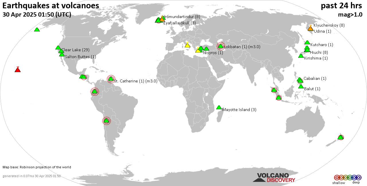
World map showing volcanoes with shallow (less than 50 km) earthquakes within 20 km radius during the past 24 hours on 30 Apr 2025 Number in brackets indicate nr of quakes.

Quakes detected near: Abu (13 quakes between mag 0.2-1.0), Akita-Komagatake (1 quake mag 1.6), Aracar (2 quakes between mag 3.0-3.0), Balut (1 quake mag 1.6), Bardarbunga (13 quakes between mag 0.1-1.3), Biliran (1 quake mag 1.5)
Cabalian (2 quakes between mag 2.0-2.7), Campi Flegrei (Phlegrean Fields) (9 quakes between mag 0.1-1.4), Clear Lake (23 quakes between mag 0.2-1.8), Comondu-La Purisima (1 quake mag 1.9), Coso (2 quakes between mag 1.0-1.0), Dutton (1 quake mag 1.8), Eldey (2 quakes between mag 1.1-1.2), Hasan Dagi (1 quake mag 1.0), Hiuchi (8 quakes between mag 0.3-1.1), Hrómundartindur (3 quakes between mag 0.1-1.1), Kenger (1 quake mag 1.1), Kilauea (3 quakes between mag 1.7-1.9), Kirishima (3 quakes between mag 0.1-1.6), Klyuchevskoy (9 quakes between mag 1.0-2.0), Kolumbo (11 quakes between mag 1.6-2.1), Koryaksky (1 quake mag 2.2), Krísuvík (12 quakes between mag 0.1-1.1), Kurikoma (2 quakes between mag 0.7-1.1), Kutcharo (1 quake mag 1.2), Ljósufjöll (3 quakes between mag 1.6-1.9), Long Valley (2 quakes between mag 0.7-1.4), Maunaloa (2 quakes between mag 1.7-1.8), Mayotte Island (2 quakes between mag 1.1-1.3), Nasu (2 quakes between mag 0.7-1.0), Nisyros (1 quake

Click this link to continue reading the article on the source website.
RSS feed source: Volcano Discovery.com--Global earthquake monitor

Wed, 30 Apr 2025, 07:37 | BY: EARTHQUAKEMONITOR

An earthquake of magnitude 3.6 occurred only 14 minutes ago 55 miles southeast of Kalkarindji, Northern Territory, Australia, Geoscience Australia (GeoAu) reported.
The quake hit at a shallow depth of 6.2 miles beneath the epicenter near Kalkarindji, Victoria Daly, Northern Territory, Australia, in the afternoon on Wednesday, April 30th, 2025, at 4:22 pm local time. The exact magnitude, epicenter, and depth of the quake might be revised within the next few hours or minutes as seismologists review data and refine their calculations, or as other agencies issue their report.
A second report was later issued by the European-Mediterranean Seismological Centre (EMSC), which listed it as a magnitude 3.6 earthquake as well.
According to preliminary calculations, we do not expect that the quake was felt by many people and did not cause any damage. In Kalkarindji (pop. 350, 55 miles away), the quake was probably not felt.

If you felt it, report it through our site or app right now!

Download and Upgrade the Volcanoes & Earthquakes app to get one of the fastest seismic alerts online:
Android | IOS
Earthquake data:

I felt this quake

Date & time: Apr 30, 2025 04:52 pm (GMT +9:30) local time (30 Apr 2025 07:22 GMT)
Magnitude: 3.6
Depth: 10.00 km
Epicenter latitude / longitude: 17.88°S / 131.53°E (Australia)
Primary data source: GeoAu

Click this link to continue reading the article on the source website.

RSS feed source: Volcano Discovery.com--Global earthquake monitor

Date and TimeMag
DepthDistanceLocationDetailsMap Apr 18, 09:20 pm (Lima)

4.6

10 km15 km (9.5 mi) to the NE Loreto, Peru InfoDec 24, 2024 10:12 am (Lima)

4.0

42 km37 km (23 mi) to the S Peru-Ecuador Border Region InfoAug 24, 2024 12:05 am (Lima)

4.9

0 km97 km (60 mi) to the E 259 km north of Yurimaguas, Loreto, Peru InfoAug 4, 2024 01:57 am (Guayaquil)

4.4

103 km93 km (58 mi) to the W 49 km northeast of Zamora, Zamora Chinchipe, Ecuador 1 reportInfoJun 28, 2024 07:09 am (Lima)

4.2

10 km102 km (63 mi) to the SW Peru-Ecuador Border Region InfoMay 14, 2024 11:39 am (Guayaquil)

4.4

30 km78 km (48 mi) to the N 69 km southeast of Macas, Morona-Santiago, Ecuador InfoMar 13, 2024 04:23 am (Lima)

4.3

10.6 km32 km (20 mi) to the E Loreto, Peru InfoDec 18, 2022 07:57 pm (Lima)

4.9

101 km93 km (58 mi) to the E 286 km north of Yurimaguas, Loreto, Peru 4 reportsInfoNov 28, 2021 05:52 am (Lima)

7.5

126 km148 km (92 mi) to the SE 43 km north of Barranca, Loreto, Peru 755 reportsInfoAug 31, 2021 04:11 am (Guayaquil)

5.1

10 km66 km (41 mi) to the W Morona Santiago, 89 km southeast of Cuenca, Provincia del Azuay, Ecuador 21 reportsInfoAug 15, 2021 12:40 am (Lima)

5.3

93 km81 km (50 mi) to the E Loreto, 267 km northeast of La Peca, Amazonas, Peru 25 reportsInfoJul 16, 2021 03:42 pm (Lima)

5.2

10 km55 km (34 mi) to the E Peru-Ecuador Border Region 21 reportsInfoFeb 5, 2020 02:57 am (Lima)

4.8

57 km96 km (60 mi) to the S 356 km southeast of Guayaquil, Guayas, Ecuador, Peru InfoFeb 22, 2019 05:17 am (Guayaquil)

7.4

148 km193 km (120 mi)

Click this link to continue reading the article on the source website.