RSS feed source: Volcano Discovery.com--Global earthquake monitor

33 km (20 mi)

N of epicenter

Oficina Victoria

(pop: 83)

II: Very weak

Provincia del Tamarugal, Tarapacá 43 km (27 mi)

W of epicenter

Rio Seco

(pop: 145)

II: Very weak

Provincia de Iquique, Tarapacá 47 km (29 mi)

N of epicenter

Colonia Pintados

(pop: 143)

II: Very weak

Provincia del Tamarugal, Tarapacá 50 km (31 mi)

SW of epicenter

Caleta Chipana

(pop: 84)

II: Very weak

Provincia de Iquique, Tarapacá 58 km (36 mi)

NW of epicenter

Chanavayita

(pop: 603)

II: Very weak

Provincia de Iquique, Tarapacá 66 km (41 mi)

NW of epicenter

Playa Quinteros

(pop: 20)

II: Very weak

Provincia de Iquique, Tarapacá 73 km (45 mi)

E of epicenter

Huatacondo

(pop: 55)

II: Very weak

Provincia del Tamarugal, Tarapacá 73 km (46 mi)

NE of epicenter

Pica

(pop: 9,300)

II: Very weak

Provincia del Tamarugal, Tarapacá 74 km (46 mi)

S of epicenter

Quillagua

(pop: 141)

II: Very weak

Tocopilla, Region de Antofagasta 77 km (48 mi)

N of epicenter

La Tirana

(pop: 1,530)

II: Very weak

Provincia del Tamarugal, Tarapacá 78 km (49 mi)

NW of epicenter

Los Verdes

(pop: 216)

II: Very weak

Provincia de Iquique, Tarapacá 85 km (53 mi)

N of epicenter

Pozo Almonte

(pop: 15,700)

II: Very weak

Provincia del Tamarugal, Tarapacá

Click this link to continue reading the article on the source website.

RSS feed source: Volcano Discovery.com--Global earthquake monitor

Tue, 6 May 2025, 14:43 | BY: EARTHQUAKEMONITOR

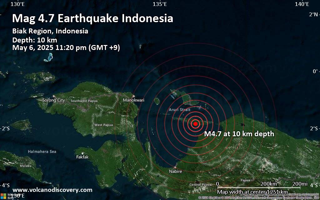
The European-Mediterranean Seismological Centre (EMSC) reported a magnitude 4.7 quake in Indonesia near Biak, Biak Numfor Regency, Papua, only 22 minutes ago. The earthquake hit late at night on Tuesday, May 6th, 2025, at 11:20 pm local time at a shallow depth of 10. km. The exact magnitude, epicenter, and depth of the quake might be revised within the next few hours or minutes as seismologists review data and refine their calculations, or as other agencies issue their report.
Our monitoring service identified a second report from the citizen-seismograph network of RaspberryShake which listed the quake at magnitude 4.7 as well. A third agency, the German Research Centre for Geosciences (GFZ), reported the same quake at magnitude 4.7.
Based on the preliminary seismic data, the quake should not have caused any significant damage, but was probably felt by many people as light vibration in the area of the epicenter.
Weak shaking might have been felt in Biak (pop. 4,500) located 76 km from the epicenter, and Insrom (pop. 3,500) 81 km away.
VolcanoDiscovery will automatically update magnitude and depth if these change and follow up if other significant news about the quake become available. If you’re in the area, please send us your experience through our reporting mechanism, either online or via our mobile app. This will

Click this link to continue reading the article on the source website.
RSS feed source: Volcano Discovery.com--Global earthquake monitor

Tue, 6 May 2025, 14:28 | BY: EARTHQUAKEMONITOR

Just 13 minutes ago, a 2.9-magnitude earthquake struck near Baza, Granada, Andalusia, Spain. The tremor was recorded in the afternoon on Tuesday, May 6th, 2025, at 4:14 pm local time, at a shallow depth of 10. km below the surface.
The event was filed by Spain’s Instituto Geográfico Nacional (IGN), the first seismological agency to report it.
Our monitoring service identified a second report from the citizen-seismograph network of RaspberryShake which listed the quake at magnitude 2.9 as well.
Towns or cities near the epicenter where the quake might have been felt as very weak shaking include Baza (pop. 23,400) located 3 km from the epicenter, Caniles (pop. 4,100) 5 km away, Zujar (pop. 2,600) 11 km away, Benamaurel (pop. 2,300) 17 km away, and Cortes de Baza (pop. 2,400) 21 km away. In Pozo Alcon (pop. 5,400, 30 km away), La Mojonera (pop. 7,800, 35 km away), and Guadix (pop. 20,400, 38 km away), the quake was probably not felt.

If you felt it, report it through our site or app right now!

Download and Upgrade the Volcanoes & Earthquakes app to get one of the fastest seismic alerts online:
Android | IOS
Earthquake data:

I felt this quake

Date & time: May 6, 2025 02:14 pm (Universal Time) local time (6 May 2025 14:14 GMT)
Magnitude: 2.7
Depth: 11.00 km
Epicenter latitude / longitude:

Click this link to continue reading the article on the source website.

RSS feed source: Volcano Discovery.com--Global earthquake monitor

Date and TimeMag
DepthDistanceLocationDetailsMap May 6, 11:20 pm (Jayapura)

4.6

27 km5.6 km (3.5 mi) to the S Yapen Islands Regency, 76 km southeast of Biak, IndonesiaI FELT IT InfoApr 4, 04:18 pm (Jayapura)

4.3

10 km74 km (46 mi) to the W Yapen Islands Regency, South Papua, 67 km southwest of Biak, Indonesia InfoApr 3, 03:40 pm (Jayapura)

4.1

5 km80 km (50 mi) to the W South Pacific Ocean, 69 km southwest of Biak, Indonesia InfoFeb 14, 05:41 am (Jayapura)

4.2

25 km100 km (62 mi) to the S Kabupaten Waropen, South Papua, 118 km northeast of Nabire, Indonesia InfoDec 1, 2024 02:58 am (Jayapura)

4.8

28 km76 km (47 mi) to the SE Kabupaten Waropen, South Papua, 178 km northeast of Nabire, Indonesia InfoApr 6, 2013 01:42 pm (Jayapura)

7.0

66 km307 km (191 mi) to the SE Tolikara Regency, South Papua, 272 km southwest of Jayapura, Indonesia 2 reportsInfoJul 17, 2012 01:33 am (Jayapura)

5.7

10 km98 km (61 mi) to the NE Near N Coast of Papua, Indonesia InfoJun 27, 2011 12:03 am (Jayapura)

5.4

2 km83 km (52 mi) to the SE Kabupaten Waropen, South Papua, 447 km west of Jayapura, Indonesia InfoJun 26, 2011 09:26 pm (Jayapura)

5.4

10 km55 km (34 mi) to the SE South Pacific Ocean, 40 km southeast of Pulau Ambai Island, Papua, Indonesia InfoJun 26, 2011 09:19 pm (Jayapura)

5.6

19 km81 km (50 mi) to the SE Kabupaten Waropen, South Papua, 166 km northeast of Nabire, Indonesia InfoJun 26, 2011 09:16 pm (Jayapura)

6.3

17 km77 km (48 mi) to the SE Kabupaten Waropen, South Papua, 166 km northeast of Nabire, Indonesia InfoJun 16,

Click this link to continue reading the article on the source website.