RSS feed source: Volcano Discovery.com--Global earthquake monitor

Tue, 20 May 2025, 18:00 1747764004 | BY: EARTHQUAKEMONITOR

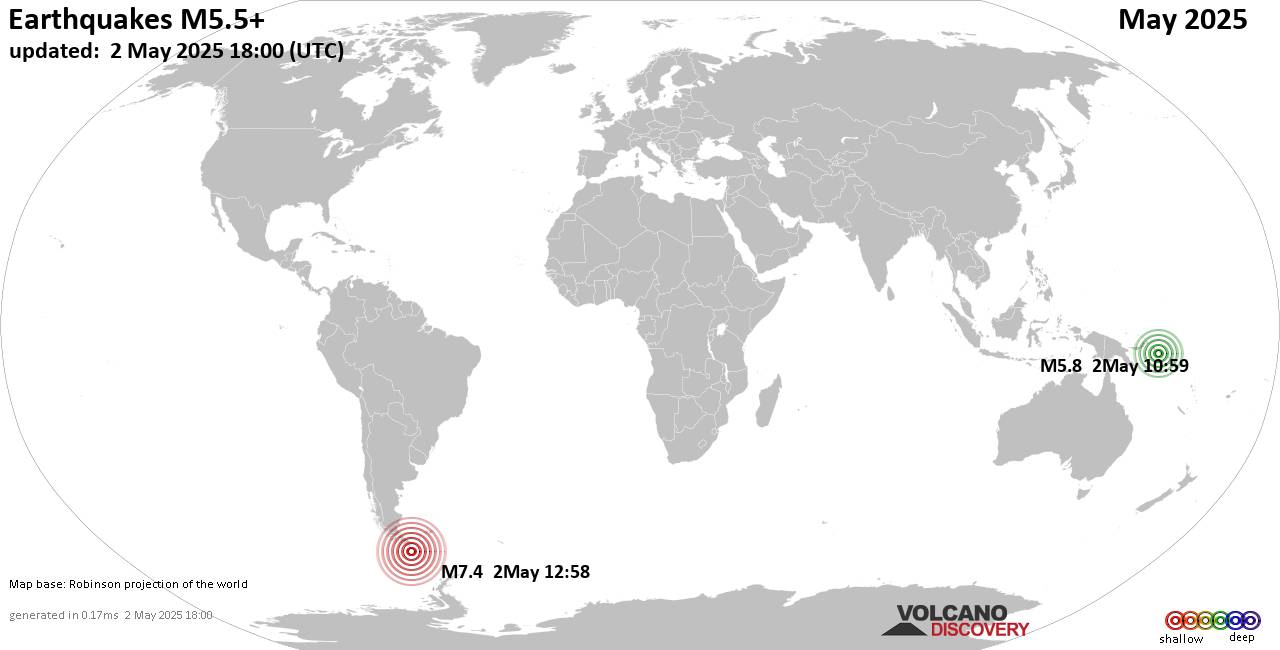
Worldwide earthquakes above magnitude 5.5 during May 2025

Summary: 1 quake 7.0+, 8 quakes 6.0+, 88 quakes 5.0+, 719 quakes 4.0+, 3771 quakes 3.0+, 7489 quakes 2.0+ (12076 total)
This report is being updated every day.
Magnitude 9+: none
Magnitude 8+: none
Magnitude 7+: 1 earthquake
Magnitude 6+: 8 earthquakes
Magnitude 5+: 88 earthquakes
Magnitude 4+: 719 earthquakes
Magnitude 3+: 3771 earthquakes
Magnitude 2+: 7489 earthquakes
No quakes of magnitude 8 or higherTotal seismic energy estimate: 1 x 10¹⁶ joules (2816 gigawatt hours, equivalent to 2.4 x 10⁶ tons of TNT or 151.4 atomic bombs!) | equivalent to ONE quake of magnitude 7.5 learn moreList of 10 largest earthquakes in the world during May 2025:#1: Mag 7.4 South Atlantic Ocean, 236 km southeast of Isla Phillips Island, Region de Magallanes y Antartica Chilena, ChileFriday, May 2, 2025, at 09:58 am (GMT -3) – #2: Mag 6.3 South Atlantic Ocean, 333 km southeast of Isla Phillips Island, Region de Magallanes y Antartica Chilena, ChileFriday, May 2, 2025, at 02:59 pm (GMT -3) – #3: Mag 6.0 156 km west of Gorontalo, Kota Gorontalo, Gorontalo, IndonesiaSaturday, May 3, 2025, at 08:51 pm (Makassar time) – #4: Mag 6.0 Southern East Pacific RiseSunday, May 4, 2025, at 08:55 pm (GMT -7) – #5: Mag 5.9 7.8 km south of Blangpidie, IndonesiaSunday, May 11, 2025, at 03:57 pm (Jakarta

Click this link to continue reading the article on the source website.
RSS feed source: Volcano Discovery.com--Global earthquake monitor

Wed, 21 May 2025, 17:50 | BY: EARTHQUAKEMONITOR

World map showing volcanoes with shallow (less than 50 km) earthquakes within 20 km radius during the past 24 hours on 21 May 2025 Number in brackets indicate nr of quakes.

Quakes detected near: Abu (17 quakes between mag 0.1-1.0), Apaneca Range (1 quake mag 2.0), Apo (1 quake mag 3.0), Arayat (1 quake mag 3.0), Atacazo (1 quake mag 2.9), Bardarbunga (3 quakes between mag 0.8-2.5)
Brennisteinsfjöll (4 quakes between mag 1.0-1.2), Cabalian (2 quakes between mag 2.2-2.8), Campi Flegrei (Phlegrean Fields) (3 quakes between mag 0.1-1.0), Clear Lake (41 quakes between mag 0.2-1.9), Coso (2 quakes between mag 0.7-1.3), Eldey (2 quakes between mag 1.4-1.6), Etna (1 quake mag 1.7), Grímsnes (5 quakes between mag 0.2-1.2), Hiuchi (8 quakes between mag 0.1-1.6), Hrómundartindur (8 quakes between mag 0.3-1.0), Kamen (1 quake mag 1.3), Kilauea (1 quake mag 2.0), Klyuchevskoy (19 quakes between mag 0.4-1.4), Kolumbo (17 quakes between mag 1.1-2.1), Kurikoma (4 quakes between mag 0.2-1.5), La Palma (1 quake mag 1.6), Ljósufjöll (10 quakes between mag 0.0-2.9), Maroa (4 quakes between mag 1.4-2.3), Mayotte Island (1 quake mag 2.0), Okataina (Tarawera) (1 quake mag 2.4), Ontake-san (4 quakes between mag 0.1-1.0), Oshima (2 quakes between mag 0.9-2.7), Osore-yama (2 quakes between mag 0.7-1.3), Pocdol Mountains (2 quakes between mag 1.8-3.4), Prestahnukur (1 quake

Click this link to continue reading the article on the source website.

RSS feed source: Volcano Discovery.com--Global earthquake monitor

Date and TimeMag
DepthDistanceLocationDetailsMap May 17, 03:31 am (GMT -7)

4.0

13 km18 km (10.9 mi) to the S North Pacific Ocean, 76 km south of Ometepec, Estado de Guerrero, MexicoI FELT IT InfoMay 5, 03:03 pm (Mexico City)

4.2

5.6 km69 km (43 mi) to the E 7.2 km southeast of Pinotepa Nacional, Estado de Oaxaca, Mexico InfoApr 30, 04:09 pm (Mexico City)

4.3

27 km80 km (50 mi) to the N 26 km northwest of Ometepec, Estado de Guerrero, Mexico InfoApr 29, 01:53 am (GMT -6)

4.0

15 km47 km (29 mi) to the E 19 km west of Pinotepa Nacional, Estado de Oaxaca, Mexico InfoApr 28, 04:00 am (GMT -7)

4.0

5 km32 km (20 mi) to the SE North Pacific Ocean, 54 km southwest of Pinotepa Nacional, Mexico InfoApr 22, 02:06 am (Mexico City)

4.5

11 km58 km (36 mi) to the NW North Pacific Ocean, 48 km south of Ayutla de los Libres, Mexico 1 reportInfoApr 18, 06:15 pm (GMT -7)

5.0

5.7 km10.3 km (6.4 mi) to the W North Pacific Ocean, 64 km southwest of Ometepec, Estado de Guerrero, Mexico InfoApr 18, 01:25 pm (GMT -7)

4.2

5 km13 km (8.1 mi) to the W Offshore Guerrero, Mexico 1 reportInfoSep 7, 2021 08:47 pm (Mexico City)

7.1

10 km151 km (94 mi) to the NW North Pacific Ocean, 8 km south of Acapulco de Juárez, Guerrero, Mexico 405 reportsInfoMar 19, 2021 09:06 pm (Mexico City)

5.7

19 km44 km (27 mi) to the NW 59 Km Al SURESTE De SAN MARCOS, GRO, Mexico 66 reportsInfoJun 23, 2020 03:29 pm (Universal Time)

7.1

10 km310 km (193 mi) to the E

Click this link to continue reading the article on the source website.

RSS feed source: Volcano Discovery.com--Global earthquake monitor

Date and TimeMag
DepthDistanceLocationDetailsMap Apr 19, 03:35 am (Jakarta)

4.7

133 km56 km (35 mi) to the SW Kabupaten Mandailing Natal, 111 km southeast of Padangsidempuan, Indonesia InfoMar 3, 08:04 am (Jakarta)

4.6

200 km32 km (20 mi) to the N Kabupaten Rokan Hulu, Riau, 103 km east of Padangsidempuan, Indonesia InfoFeb 7, 03:04 am (Jakarta)

4.4

215 km4.4 km (2.8 mi) to the E Kabupaten Rokan Hulu, 149 km west of Pekanbaru, Kota Pekanbaru, Riau, Indonesia InfoNov 11, 2024 03:13 pm (Jakarta)

4.0

103 km87 km (54 mi) to the W Kabupaten Mandailing Natal, 56 km south of Padangsidempuan, Indonesia InfoSep 26, 2024 08:17 am (Jakarta)

4.5

134 km50 km (31 mi) to the SW Kabupaten Mandailing Natal, 108 km southeast of Padangsidempuan, Indonesia 1 reportInfoJan 21, 2024 07:40 pm (Jakarta)

4.2

255 km87 km (54 mi) to the E Kabupaten Kampar, 67 km west of Pekanbaru, Kota Pekanbaru, Riau, Indonesia InfoApr 25, 2023 03:00 am (Jakarta)

7.3

84 km277 km (172 mi) to the SW Indian Ocean, 76 km northwest of Siberut Island, Indonesia 243 reportsInfoFeb 25, 2022 08:39 am (Jakarta)

6.1

4 km72 km (45 mi) to the S Kabupaten Pasaman, 66 km northwest of Bukittinggi, Indonesia 1559 reportsInfoFeb 25, 2022 08:35 am (Jakarta)

5.0

10 km70 km (44 mi) to the S Kabupaten Pasaman Barat, 74 km northwest of Bukittinggi, Indonesia 24 reportsInfoAug 11, 2021 12:19 pm (Jakarta)

5.2

15 km98 km (61 mi) to the NW Kabupaten Padang Lawas Utara, 16 km east of Padangsidempuan, Indonesia 117 reportsInfoApr 30, 2020 03:20 pm (Jakarta)

4.9

10 km77 km (48 mi) to the W Kabupaten Mandailing Natal, 36 km southeast of Padangsidempuan, Indonesia 36 reportsInfoJan

Click this link to continue reading the article on the source website.