RSS feed source: USGS Earthquake Hazards Program
Time2025-06-10 11:18:02 UTC2025-06-10 11:18:02 UTC at epicenterLocation17.420°S 167.541°EDepth10.00 km (6.21 mi)
Click this link to continue reading the article on the source website.
RSS feed source: USGS Earthquake Hazards Program
Time2025-06-10 11:18:02 UTC2025-06-10 11:18:02 UTC at epicenterLocation17.420°S 167.541°EDepth10.00 km (6.21 mi)
Click this link to continue reading the article on the source website.
RSS feed source: USGS Earthquake Hazards Program
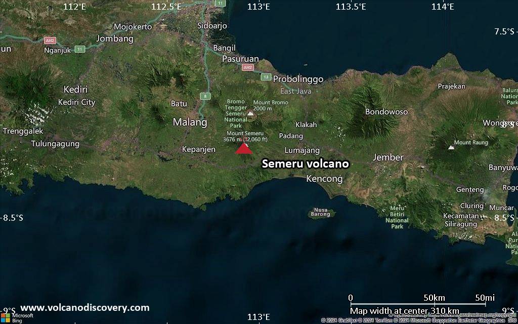
<!–div style="font-size:14px;text-align:center;border:3px solid blue;border-radius:5px;padding:3px;margin:5px;background:#eee"><a href="https://www.volcanoesandearthquakes.com/app/volcano-report.php?volcanoId=44" style="text-decoration:none" target="_blank" rel="noopener noreferrer nofollow" title="Share a volcano (activity) report, submit a photo or other interesting news!” onclick=”window.open(this.href,’Volcano Report’,’status=0,toolbar=0,location=0,directories=0,menubar=0,resizable=1,scrollbars=1,height=500,width=450′);return false”>Send Volcano Report</div–> Stratovolcano 3676 m (12,060 ft)
East Java, Indonesia, -8.11°S / 112.92°E
Current status: erupting (4 out of 5) Semeru volcano eruptions:
1818, 1829, 1830, 1832, 1836, 1838, 1842, 1844, 1845, 1848, 1849(?), 1851, 1856, 1857, 1865, 1866(?), 1887, 1887, 1888, 1889-91, 1892, 1893, 1893-94, 1895, 1896, 1897, 1899, 1899, 1900, 1901, 1903, 1904, 1905, 1907, 1908, 1909-10, 1910-11, 1911, 1912, 1913, 1941-42, 1945, 1946, 1946-47, 1950-64, 1967-ongoing
Typical eruption style
Explosive. Near constant strombolian activity, occasionally stronger explosions, lava flows and pyroclastic flows.
Click this link to continue reading the article on the source website.
RSS feed source: USGS Earthquake Hazards Program
Date and TimeMag
DepthDistanceLocationDetailsMap Jun 9, 11:48 am (GMT +8)
4.4
10 km78 km (48 mi) to the SE Philippine Sea, 83 km east of Laoang, Philippines I FELT IT InfoMay 27, 10:31 pm (GMT +8)
4.6
10 km81 km (50 mi) to the SE Philippine Sea, 79 km east of Laoang, Philippines 1 reportInfoMay 9, 06:40 pm (GMT +8)
4.5
10 km83 km (52 mi) to the NW Philippine Sea, 57 km east of Virac, Province of Catanduanes, Bicol, Philippines InfoMay 8, 12:41 am (GMT +8)
4.9
27 km85 km (53 mi) to the E Philippine Sea, 87 km northeast of Gamay, Philippines InfoMay 7, 05:36 pm (GMT +8)
4.7
10 km7.3 km (4.5 mi) to the NW Philippine Sea, 50 km north of Laoang Island, Philippines InfoApr 4, 2023 08:54 pm (GMT +8)
6.2
10 km92 km (57 mi) to the NE Philippine Sea, 138 km east of Catanduanes Island, Philippines 48 reportsInfoDec 9, 2022 02:32 pm (GMT +8)
5.8
9 km73 km (46 mi) to the E Philippine Sea, 148 km northeast of Catarman, Philippines 7 reportsInfoApr 10, 2017 08:43 am (GMT +8)
5.7
10 km17 km (10.4 mi) to the E Philippine Sea, 52 km northeast of Laoang, Philippines 3 reportsInfoAug 31, 2012 08:47 pm (GMT +8)
7.6
28 km290 km (180 mi) to the SE Philippine Sea, Eastern Visayas, 239 km northeast of Butuan, Philippines 8 reportsInfoJan 28, 2010 02:49 am (GMT +8)
5.9
29 km80 km (50 mi) to the NE Philippine Sea, 128 km northeast of Laoang Island, Philippines InfoAug 15, 2008 06:25 pm (Manila)
6.0
10 km93 km (58 mi) to the W Samar, Philippines InfoMar 3, 2008 10:11 pm
Click this link to continue reading the article on the source website.
RSS feed source: USGS Earthquake Hazards Program
Tue, 10 Jun 2025, 10:52 | BY: EARTHQUAKEMONITOR
A shallow magnitude 5.0 earthquake was reported early evening near Kinablangan, Davao Oriental, Davao, Philippines.
According to Indonesia’s Meteorology, Climatology, and Geophysical Agency, the quake hit on Tuesday, June 10th, 2025, at 6:43 pm local time at a shallow depth of 10. km. Shallow earthquakes are felt more strongly than deeper ones as they are closer to the surface. The exact magnitude, epicenter, and depth of the quake might be revised within the next few hours or minutes as seismologists review data and refine their calculations, or as other agencies issue their report.
Our monitoring service identified a second report from the Philippine Institute of Volcanology and Seismology (PHIVOLCS) which listed the quake at magnitude 4.4. A third agency, the European-Mediterranean Seismological Centre (EMSC), reported the same quake at magnitude 4.7.
Based on the preliminary seismic data, the quake should not have caused any significant damage, but was probably felt by many people as light vibration in the area of the epicenter.
Weak shaking might have been felt in Kinablangan (pop. 5,400) located 106 km from the epicenter, Taytayan (pop. 6,900) 110 km away, Baganga (pop. 10,100) 110 km away, Cateel (pop. 6,600) 113 km away, and Lingig (pop. 6,400) 115 km away.
VolcanoDiscovery will automatically update magnitude and depth if these change and follow up if other
Click this link to continue reading the article on the source website.