RSS feed source: USGS Earthquake Hazards Program
Time2025-04-25 21:19:50 UTC2025-04-25 21:19:50 UTC at epicenterLocation0.377°N 122.175°EDepth136.52 km (84.83 mi)
Click this link to continue reading the article on the source website.
RSS feed source: USGS Earthquake Hazards Program
Time2025-04-25 21:19:50 UTC2025-04-25 21:19:50 UTC at epicenterLocation0.377°N 122.175°EDepth136.52 km (84.83 mi)
Click this link to continue reading the article on the source website.
RSS feed source: USGS Earthquake Hazards Program
<!–div style="font-size:14px;text-align:center;border:3px solid blue;border-radius:5px;padding:3px;margin:5px;background:#eee"><a href="https://www.volcanoesandearthquakes.com/app/volcano-report.php?volcanoId=44" style="text-decoration:none" target="_blank" rel="noopener noreferrer nofollow" title="Share a volcano (activity) report, submit a photo or other interesting news!” onclick=”window.open(this.href,’Volcano Report’,’status=0,toolbar=0,location=0,directories=0,menubar=0,resizable=1,scrollbars=1,height=500,width=450′);return false”>Send Volcano Report</div–> Stratovolcano 3676 m (12,060 ft)
East Java, Indonesia, -8.11°S / 112.92°E
Current status: erupting (4 out of 5) Semeru volcano eruptions:
1818, 1829, 1830, 1832, 1836, 1838, 1842, 1844, 1845, 1848, 1849(?), 1851, 1856, 1857, 1865, 1866(?), 1887, 1887, 1888, 1889-91, 1892, 1893, 1893-94, 1895, 1896, 1897, 1899, 1899, 1900, 1901, 1903, 1904, 1905, 1907, 1908, 1909-10, 1910-11, 1911, 1912, 1913, 1941-42, 1945, 1946, 1946-47, 1950-64, 1967-ongoing
Typical eruption style
Explosive. Near constant strombolian activity, occasionally stronger explosions, lava flows and pyroclastic flows.
Click this link to continue reading the article on the source website.
RSS feed source: USGS Earthquake Hazards Program
Time2025-04-26 00:27:47 UTC2025-04-26 00:27:47 UTC at epicenterLocation22.222°S 170.476°EDepth10.00 km (6.21 mi)
Click this link to continue reading the article on the source website.
RSS feed source: USGS Earthquake Hazards Program
Fri, 25 Apr 2025, 23:50 | BY: EARTHQUAKEMONITOR
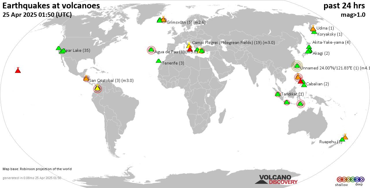
World map showing volcanoes with shallow (less than 50 km) earthquakes within 20 km radius during the past 24 hours on 25 Apr 2025 Number in brackets indicate nr of quakes.
Quakes detected near: Apaneca Range (2 quakes between mag 2.0-2.9), Bardarbunga (7 quakes between mag 0.4-1.5), Baru (1 quake mag 3.1), Bolshoi Semiachik (1 quake mag 2.3), Cabalian (2 quakes between mag 2.6-3.2), Campi Flegrei (Phlegrean Fields) (16 quakes between mag 0.1-2.7)
Clear Lake (40 quakes between mag 0.2-2.0), Daisen (1 quake mag 1.4), Eldey (2 quakes between mag 1.5-1.8), Fuerteventura (1 quake mag 3.0), Garibaldi (1 quake mag 3.0), Gede-Pangrango (1 quake mag 2.5), Hulubelu (1 quake mag 1.4), Jan Mayen (7 quakes between mag 1.2-2.6), Kilauea (1 quake mag 1.8), Klyuchevskoy (3 quakes between mag 1.2-1.9), Kolumbo (20 quakes between mag 0.8-2.5), Krísuvík (7 quakes between mag 0.2-1.6), Kurikoma (2 quakes between mag 0.1-2.3), La Palma (1 quake mag 1.2), Myoko (1 quake mag 1.5), Nuevo Mundo (1 quake mag 3.4), Roundtop (1 quake mag 1.5), Sandal (1 quake mag 2.1), Sangeang Api (1 quake mag 2.7), Santorini (2 quakes between mag 1.5-2.1), Sousaki (1 quake mag 2.2), Svartsengi (2 quakes between mag 0.5-1.4), Taal (1 quake mag 3.0), Tenerife (3 quakes between mag 0.3-1.1), Tsurumi (6 quakes between mag 0.2-1.8), Udina (2
Click this link to continue reading the article on the source website.