RSS feed source: Volcano Discovery.com--Global earthquake monitor

Date and TimeMag
DepthDistanceLocationDetailsMap May 19, 2020 11:43 pm (Los Angeles)

4.2

16 km68 km (42 mi) to the W 14 mi west of Alamo, Lincoln County, Nevada, United States InfoJun 30, 2019 04:43 pm (Los Angeles)

4.2

3.1 km65 km (40 mi) to the NE 4.1 mi east of Panaca, Lincoln County, Nevada, United States 11 reportsInfoJan 15, 2016 04:37 pm (Denver)

4.2

1 km69 km (43 mi) to the NE 12 mi west of Enterprise, Washington County, Utah, United States InfoMay 22, 2015 11:47 am (Los Angeles)

5.3

4 km3.1 km (2 mi) to the N 37 km SSW of Caliente, Nevada 49 reportsInfoJan 29, 2014 01:30 am (Universal Time)

4.0

7.1 km47 km (29 mi) to the E Lincoln County, Nevada, 33 mi northwest of St. George, Washington County, Utah, United States 1 reportInfoJan 28, 2014 04:20 pm (Universal Time)

4.1

7.3 km47 km (29 mi) to the E Lincoln County, Nevada, 33 mi northwest of St. George, Washington County, Utah, United States InfoNov 8, 2009 11:34 am (Los Angeles)

4.1

0 km18 km (11 mi) to the NE Lincoln County, 42 mi northwest of Mesquite, Clark County, Nevada, United States InfoJun 30, 2008 03:49 pm (Los Angeles)

4.3

0 km30 km (19 mi) to the E Lincoln County, Nevada, 43 mi west of St. George, Washington County, Utah, United States InfoJun 19, 2006 09:16 pm (Los Angeles)

4.4

0 km4.9 km (3 mi) to the SW Lincoln County, 44 mi northwest of Mesquite, Clark County, Nevada, United States InfoMay 15, 2004 06:29 pm (Los Angeles)

4.5

0 km18 km (10.9 mi) to the W Lincoln County, 54 mi northwest

Click this link to continue reading the article on the source website.

RSS feed source: Volcano Discovery.com--Global earthquake monitor

56 km (35 mi)

SE of epicenter

Ocampo

(pop: 3,680)

III: Weak

Estado de Coahuila de Zaragoza 84 km (52 mi)

W of epicenter

El Alicante

(pop: 209)

II: Very weak

Ocampo, Estado de Coahuila de Zaragoza 85 km (53 mi)

SE of epicenter

Victoria

(pop: 27)

II: Very weak

Cuatro Cienegas, Estado de Coahuila de Zaragoza 95 km (59 mi)

N of epicenter

La Sabina

(pop: 167)

II: Very weak

Ocampo, Estado de Coahuila de Zaragoza 97 km (60 mi)

SW of epicenter

Laguna del Rey (Quimicas del Rey)

(pop: 2,650)

II: Very weak

Ocampo, Estado de Coahuila de Zaragoza 101 km (63 mi)

SW of epicenter

La Esmeralda

(pop: 1,110)

II: Very weak

Sierra Mojada, Estado de Coahuila de Zaragoza 105 km (65 mi)

SE of epicenter

Cuatro Cienegas de Carranza

(pop: 10,300)

II: Very weak

Cuatro Cienegas, Estado de Coahuila de Zaragoza 107 km (66 mi)

E of epicenter

Negros Maskogos (Nacimiento)

(pop: 253)

II: Very weak

Muzquiz, Estado de Coahuila de Zaragoza 108 km (67 mi)

E of epicenter

San Antonio de las Higueras

(pop: 137)

II: Very weak

San Buenaventura, Estado de Coahuila de Zaragoza 109 km (67 mi)

W of epicenter

Hercules

(pop: 3,910)

II: Very weak

Sierra Mojada, Estado de Coahuila de Zaragoza 119 km

Click this link to continue reading the article on the source website.
RSS feed source: Volcano Discovery.com--Global earthquake monitor

<!–div style="font-size:14px;text-align:center;border:3px solid blue;border-radius:5px;padding:3px;margin:5px;background:#eee"><a href="https://www.volcanoesandearthquakes.com/app/volcano-report.php?volcanoId=26" style="text-decoration:none" target="_blank" rel="noopener noreferrer nofollow" title="Share a volcano (activity) report, submit a photo or other interesting news!” onclick=”window.open(this.href,’Volcano Report’,’status=0,toolbar=0,location=0,directories=0,menubar=0,resizable=1,scrollbars=1,height=500,width=450′);return false”>Send Volcano Report</div–> Stratovolcano 3,763 m / 12,346 ft
Guatemala, 14.47°N / -90.88°W
Current status: erupting (4 out of 5) Fuego volcano eruptions:
1581, 1585, 1586, 1587, 1614, 1617, 1620, 1623, 1629, 1679(?), 1685, 1686, 1689(?), 1699, 1702, 1705, 1706, 1709(?), 1710,1717,1730, 1732, 1737, 1751(?), 1765(?), 1773(?), 1799, 1826, 1829, 1850(?), 1852(?), 1855, 1856, 1857, 1860, 1861(?), 1867(?), 1880, 1896, 1932, 1944, 1949, 1953, 1955, 1957, 1962, 1963, 1966, 1967, 1971, 1973, 1974, 1975, 1977, 1987, 1999, 2002 – ongoing
Typical eruption style
Dominantly explosive, construction of lava domes and extrusion of viscous lava flows. In near constant activity, at least during the past centuries.

Click this link to continue reading the article on the source website.

RSS feed source: Volcano Discovery.com--Global earthquake monitor

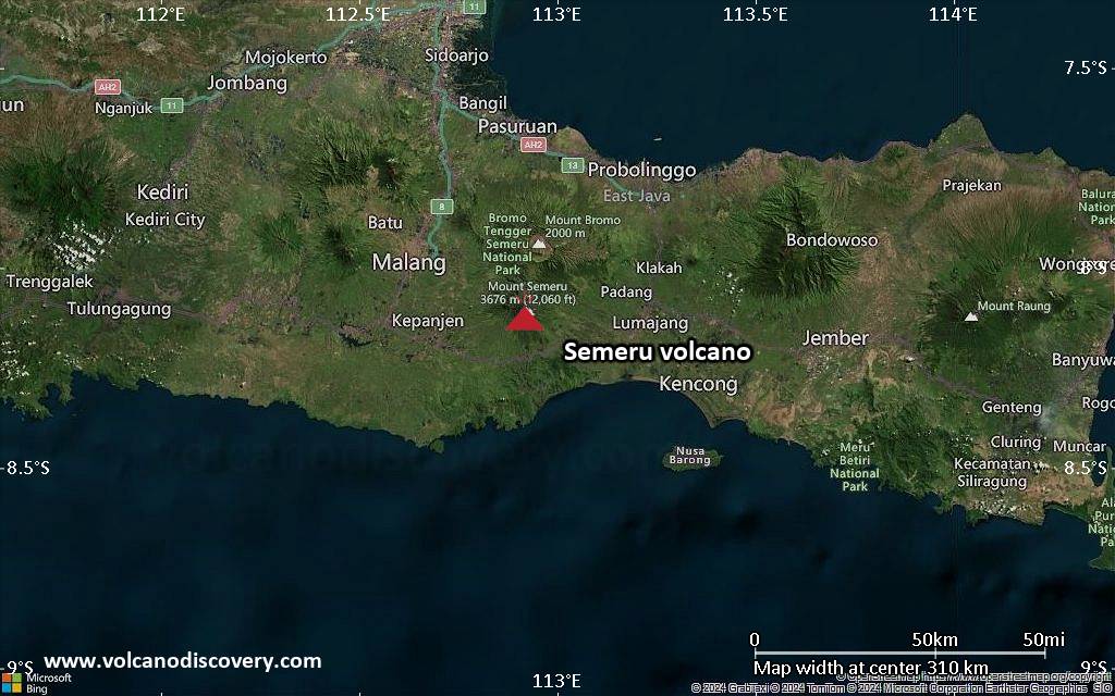
<!–div style="font-size:14px;text-align:center;border:3px solid blue;border-radius:5px;padding:3px;margin:5px;background:#eee"><a href="https://www.volcanoesandearthquakes.com/app/volcano-report.php?volcanoId=44" style="text-decoration:none" target="_blank" rel="noopener noreferrer nofollow" title="Share a volcano (activity) report, submit a photo or other interesting news!” onclick=”window.open(this.href,’Volcano Report’,’status=0,toolbar=0,location=0,directories=0,menubar=0,resizable=1,scrollbars=1,height=500,width=450′);return false”>Send Volcano Report</div–> Stratovolcano 3676 m (12,060 ft)
East Java, Indonesia, -8.11°S / 112.92°E
Current status: erupting (4 out of 5) Semeru volcano eruptions:
1818, 1829, 1830, 1832, 1836, 1838, 1842, 1844, 1845, 1848, 1849(?), 1851, 1856, 1857, 1865, 1866(?), 1887, 1887, 1888, 1889-91, 1892, 1893, 1893-94, 1895, 1896, 1897, 1899, 1899, 1900, 1901, 1903, 1904, 1905, 1907, 1908, 1909-10, 1910-11, 1911, 1912, 1913, 1941-42, 1945, 1946, 1946-47, 1950-64, 1967-ongoing
Typical eruption style
Explosive. Near constant strombolian activity, occasionally stronger explosions, lava flows and pyroclastic flows.

Click this link to continue reading the article on the source website.