RSS feed source: USGS Earthquake Hazards Program
Time2025-06-14 09:59:14 UTC2025-06-14 09:59:14 UTC at epicenterLocation35.722°S 18.713°WDepth10.00 km (6.21 mi)
Click this link to continue reading the article on the source website.
RSS feed source: USGS Earthquake Hazards Program
Time2025-06-14 09:59:14 UTC2025-06-14 09:59:14 UTC at epicenterLocation35.722°S 18.713°WDepth10.00 km (6.21 mi)
Click this link to continue reading the article on the source website.
RSS feed source: USGS Earthquake Hazards Program
Date and TimeMag
DepthDistanceLocationDetailsMap Feb 15, 2018 07:30 am (GMT -1)
5.0
10 km100 km (62 mi) to the E South Atlantic Ocean, 493 km west of Edinburgh of the Seven Seas, Saint Helena InfoJun 17, 2015 11:51 am (GMT -1)
6.8
10 km102 km (63 mi) to the E South Atlantic Ocean, 497 km west of Edinburgh of the Seven Seas, Saint Helena 1 reportInfoJan 31, 2013 09:18 pm (Universal Time)
3.9
0 km92 km (57 mi) to the E Southern Mid-Atlantic Ridge
Info
Mar 22, 2011 03:45 pm (GMT -1)
4.1
0 km95 km (59 mi) to the N Southern Mid-Atlantic Ridge InfoJun 24, 2010 03:07 am (GMT -1)
5.1
10 km100 km (62 mi) to the E Southern Mid-Atlantic Ridge InfoJul 1, 2007 02:07 am (GMT -1)
5.0
10 km98 km (61 mi) to the E Southern Mid-Atlantic Ridge InfoMar 6, 2002 02:25 pm (Universal Time)
4.9
10 km102 km (63 mi) to the E Southern Mid-Atlantic Ridge InfoMar 2, 2002 02:14 am (GMT -1)
5.9
10 km99 km (61 mi) to the E Southern Mid-Atlantic Ridge InfoOct 25, 1994 10:35 pm (GMT -1)
4.9
10 km86 km (53 mi) to the E Southern Mid-Atlantic Ridge InfoAug 3, 1992 02:06 pm (GMT -1)
4.9
10 km87 km (54 mi) to the E Southern Mid-Atlantic Ridge InfoDec 21, 1991 04:10 am (Universal Time)
4.5
10 km91 km (56 mi) to the E Southern Mid-Atlantic Ridge InfoJul 12, 1991 12:26 pm (GMT -1)
4.8
10 km84 km (52 mi) to the E Southern Mid-Atlantic Ridge InfoNov 6, 1986 05:38 pm (GMT -1)
5.1
10 km52 km (33 mi) to the E Southern Mid-Atlantic Ridge InfoNov 6, 1986 01:02 pm (GMT -1)
5.1
10 km82 km (51 mi) to the S Southern Mid-Atlantic Ridge
Click this link to continue reading the article on the source website.
RSS feed source: USGS Earthquake Hazards Program
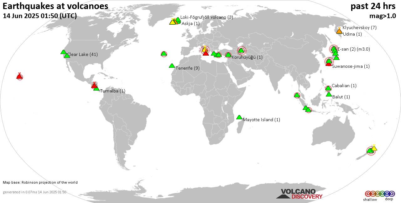
Sat, 14 Jun 2025, 09:50 | BY: EARTHQUAKEMONITOR
World map showing volcanoes with shallow (less than 50 km) earthquakes within 20 km radius during the past 24 hours on 14 Jun 2025 Number in brackets indicate nr of quakes.
Quakes detected near: Akita-Yake-yama (2 quakes between mag 0.6-1.1), Akyarlar (1 quake mag 2.6), Azuma (1 quake mag 1.5), Balut (1 quake mag 1.7), Brennisteinsfjöll (16 quakes between mag 0.1-1.5), Cabalian (1 quake mag 2.2)
Campi Flegrei (Phlegrean Fields) (9 quakes between mag 0.1-3.0), Clear Lake (44 quakes between mag 0.2-2.1), Coso (9 quakes between mag 0.1-1.8), Daisen (7 quakes between mag 0.2-1.2), E-san (2 quakes between mag 3.0-3.0), El Chichón (1 quake mag 2.3), Eldey (2 quakes between mag 1.1-1.5), Etna (3 quakes between mag 0.9-1.2), Furnas (2 quakes between mag 2.0-2.6), Gede-Pangrango (1 quake mag 2.5), Hekla (1 quake mag 1.7), Hulubelu (3 quakes between mag 2.4-3.6), Iriomote-jima (1 quake mag 1.1), Kilauea (2 quakes between mag 1.9-2.9), Kirishima (8 quakes between mag 0.2-3.0), Klyuchevskoy (16 quakes between mag 0.5-1.7), Kolumbo (8 quakes between mag 1.4-2.1), Krísuvík (6 quakes between mag 0.1-1.0), Ksudach (1 quake mag 2.1), Kuju (3 quakes between mag 0.4-2.2), Lokbatan (1 quake mag 3.0), Masaya (2 quakes between mag 2.0-2.1), Mayotte Island (1 quake mag 1.2), Mutnovsky (2 quakes between mag 0.7-1.6), Prestahnukur (2 quakes between mag 1.1-1.3), Santorini
Click this link to continue reading the article on the source website.
RSS feed source: USGS Earthquake Hazards Program
Sat, 14 Jun 2025, 09:46 | BY: EARTHQUAKEMONITOR
An earthquake of magnitude 4.8 occurred in the afternoon on Saturday, June 14th, 2025, at 5:27 pm local time near Sanchez-Mira, Cagayan, Cagayan Valley, Philippines, as reported by the European-Mediterranean Seismological Centre (EMSC).
According to preliminary data, the quake was located at a moderately shallow depth of 39. km. The exact magnitude, epicenter, and depth of the quake might be revised within the next few hours or minutes as seismologists review data and refine their calculations, or as other agencies issue their report.
A second report was later issued by the German Research Centre for Geosciences (GFZ), which listed it as a magnitude 4.9 earthquake. A third agency, the citizen-seismograph network of RaspberryShake, reported the same quake at magnitude 4.9.
Based on the preliminary seismic data, the quake should not have caused any significant damage, but was probably felt by many people as light vibration in the area of the epicenter.
Weak shaking might have been felt in Namuac (pop. 3,000) located 66 km from the epicenter, Claveria (pop. 10,600) 67 km away, Sanchez-Mira (pop. 26,200) 71 km away, and Pagudpud (pop. 4,900) 82 km away.
Other towns or cities near the epicenter where the quake might have been felt as very weak shaking include Cabaritan East (pop. 9,300) located 93 km from the epicenter, and Aparri (pop.
Click this link to continue reading the article on the source website.