RSS feed source: Volcano Discovery.com--Global earthquake monitor

Date and TimeMag
DepthDistanceLocationDetailsMap May 10, 03:49 am (Efate)

4.7

58 km9.5 km (5.9 mi) to the E 9.5 km northeast of Port Vila, Shefa Province, VanuatuI FELT IT11 reportsInfoMay 8, 09:53 pm (GMT +11)

4.8

35 km36 km (23 mi) to the W Coral Sea, 40 km west of Port Vila, Shefa Province, VanuatuI FELT IT9 reportsInfoMay 4, 02:49 am (Efate)

5.0

7.1 km33 km (21 mi) to the NW Coral Sea, 40 km northwest of Port Vila, Shefa, VanuatuI FELT IT3 reportsInfoApr 21, 04:45 am (Efate)

4.9

43 km30 km (19 mi) to the NW Coral Sea, 36 km northwest of Port Vila, Shefa, Vanuatu 23 reportsInfoApr 15, 12:36 pm (GMT +11)

4.8

35 km64 km (40 mi) to the S Coral Sea, 59 km southwest of Port Vila, Shefa Province, Vanuatu 1 reportInfoDec 22, 2024 02:30 am (Efate)

6.1

47 km30 km (18 mi) to the W Coral Sea, 33 km west of Port Vila, Shefa Province, Vanuatu 22 reportsInfoDec 17, 2024 12:47 pm (Efate)

7.3

54 km21 km (13 mi) to the W Coral Sea, 25 km west of Port Vila, Shefa, Vanuatu 50 reportsInfoMay 26, 2024 09:23 am (GMT +11)

6.3

22 km76 km (47 mi) to the NW Coral Sea, 63 km northwest of Nguna Island, Shefa Province, Vanuatu 5 reportsInfoJan 24, 2024 01:33 am (GMT +11)

6.3

31 km42 km (26 mi) to the SW Coral Sea, 39 km southwest of Port Vila, Shefa, Vanuatu 78 reportsInfoJul 12, 2022 08:10 am (GMT +11)

6.0

10 km89 km (55 mi) to the SE 82 km ESE of Port-Vila,

Click this link to continue reading the article on the source website.

RSS feed source: Volcano Discovery.com--Global earthquake monitor

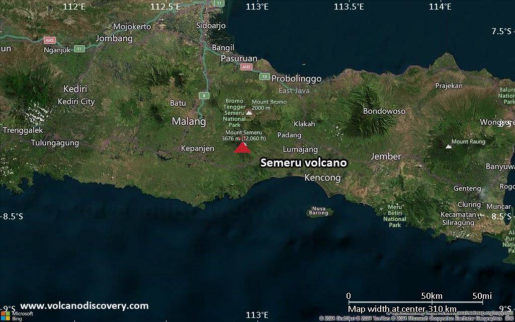
<!–div style="font-size:14px;text-align:center;border:3px solid blue;border-radius:5px;padding:3px;margin:5px;background:#eee"><a href="https://www.volcanoesandearthquakes.com/app/volcano-report.php?volcanoId=44" style="text-decoration:none" target="_blank" rel="noopener noreferrer nofollow" title="Share a volcano (activity) report, submit a photo or other interesting news!” onclick=”window.open(this.href,’Volcano Report’,’status=0,toolbar=0,location=0,directories=0,menubar=0,resizable=1,scrollbars=1,height=500,width=450′);return false”>Send Volcano Report</div–> Stratovolcano 3676 m (12,060 ft)
East Java, Indonesia, -8.11°S / 112.92°E
Current status: erupting (4 out of 5) Semeru volcano eruptions:
1818, 1829, 1830, 1832, 1836, 1838, 1842, 1844, 1845, 1848, 1849(?), 1851, 1856, 1857, 1865, 1866(?), 1887, 1887, 1888, 1889-91, 1892, 1893, 1893-94, 1895, 1896, 1897, 1899, 1899, 1900, 1901, 1903, 1904, 1905, 1907, 1908, 1909-10, 1910-11, 1911, 1912, 1913, 1941-42, 1945, 1946, 1946-47, 1950-64, 1967-ongoing
Typical eruption style
Explosive. Near constant strombolian activity, occasionally stronger explosions, lava flows and pyroclastic flows.

Click this link to continue reading the article on the source website.
RSS feed source: Volcano Discovery.com--Global earthquake monitor

Date and TimeMag
DepthDistanceLocationDetailsMap May 7, 09:41 am (GMT -5)

4.0

146 km97 km (60 mi) to the SE 38 km south of Bucaramanga, Departamento de Santander, ColombiaI FELT IT1 reportInfoApr 18, 05:31 am (Bogota)

5.2

151 km105 km (65 mi) to the SE 34 km south of Bucaramanga, Departamento de Santander, Colombia 99 reportsInfoMar 24, 04:43 pm (Bogota)

4.0

154 km99 km (61 mi) to the SE 34 km south of Bucaramanga, Departamento de Santander, Colombia InfoFeb 17, 03:48 pm (Universal Time)

4.6

161 km104 km (64 mi) to the SE 45 km south of Bucaramanga, Santander, Colombia 8 reportsInfoFeb 8, 06:40 pm (Bogota)

4.1

146 km100 km (62 mi) to the SE 38 km south of Bucaramanga, Departamento de Santander, Colombia InfoNov 16, 2024 01:25 pm (Bogota)

4.3

148 km100 km (62 mi) to the SE 31 km south of Bucaramanga, Departamento de Santander, Colombia 3 reportsInfoJun 29, 2024 04:16 am (Bogota)

4.3

152 km106 km (66 mi) to the SE 38 km south of Bucaramanga, Departamento de Santander, Colombia 9 reportsInfoApr 2, 2024 09:32 pm (Bogota)

4.5

157 km94 km (58 mi) to the SE 31 km south of Bucaramanga, Departamento de Santander, Colombia InfoMar 10, 2023 04:18 am (Bogota)

5.4

160 km114 km (71 mi) to the SE 45 km south of Bucaramanga, Santander, Colombia 1629 reportsInfoFeb 23, 2022 07:49 am (Bogota)

5.5

51 km67 km (42 mi) to the NW Departamento de Bolivar, 94 km northwest of Barrancabermeja, Colombia 406 reportsInfoJan 4, 2020 08:52 am (Bogota)

4.7

165 km103 km (64 mi) to the SE 43 km south of Bucaramanga, Santander, Colombia 1 reportInfoMay 20, 2018 06:17 am (Bogota)

4.7

155 km103 km (64 mi)

Click this link to continue reading the article on the source website.