RSS feed source: USGS Earthquake Hazards Program
Time2025-04-13 07:58:29 UTC2025-04-13 07:58:29 UTC at epicenterLocation6.373°S 151.704°EDepth10.00 km (6.21 mi)
Click this link to continue reading the article on the source website.
RSS feed source: USGS Earthquake Hazards Program
Time2025-04-13 07:58:29 UTC2025-04-13 07:58:29 UTC at epicenterLocation6.373°S 151.704°EDepth10.00 km (6.21 mi)
Click this link to continue reading the article on the source website.
RSS feed source: USGS Earthquake Hazards Program
Sun, 13 Apr 2025, 07:50 | BY: EARTHQUAKEMONITOR
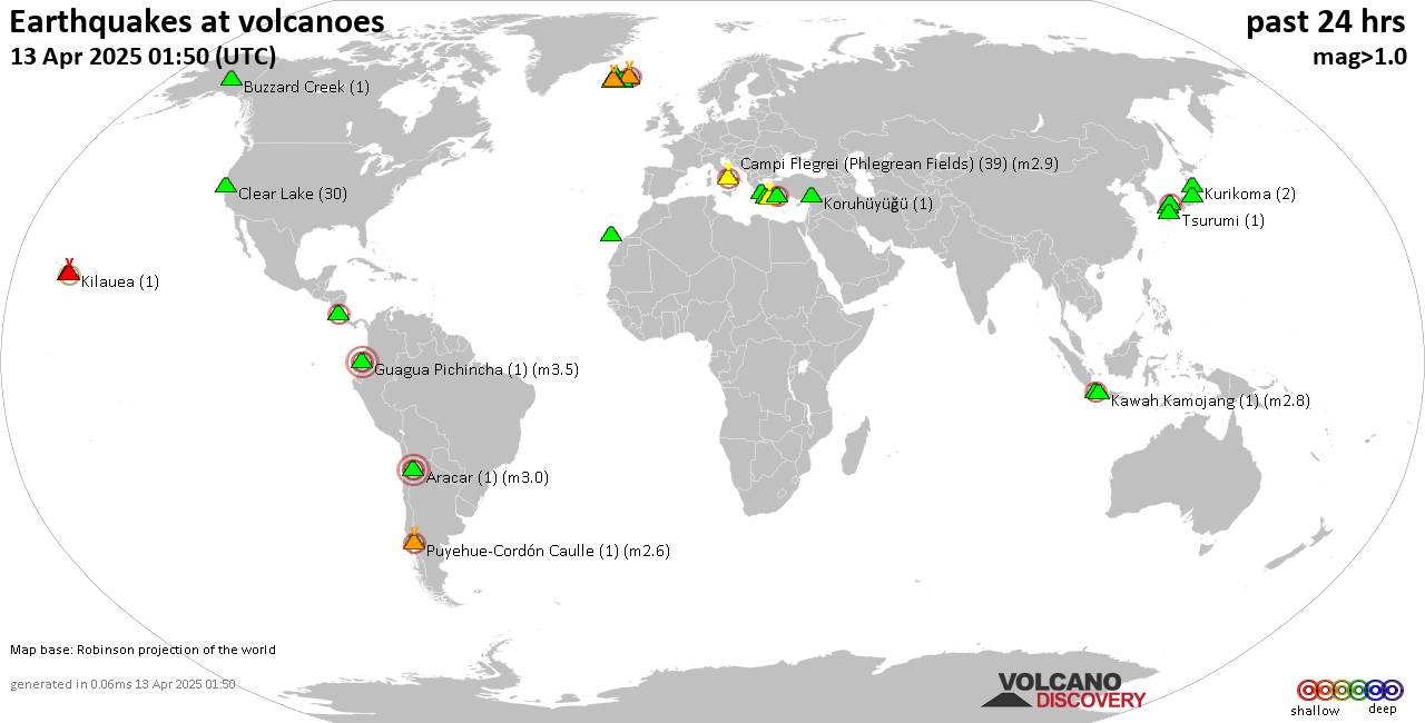
World map showing volcanoes with shallow (less than 50 km) earthquakes within 20 km radius during the past 24 hours on 13 Apr 2025 Number in brackets indicate nr of quakes.
Quakes detected near: Abu (5 quakes between mag 0.3-1.1), Akyarlar (1 quake mag 2.4), Aracar (3 quakes between mag 3.0-3.0), Bardarbunga (5 quakes between mag 0.4-2.3), Campi Flegrei (Phlegrean Fields) (45 quakes between mag 0.1-2.9), Clear Lake (33 quakes between mag 0.2-1.4)
Cofre de Perote (1 quake mag 3.3), Conchagüita (1 quake mag 2.3), Eldey (1 quake mag 1.8), Eyafjallajökull (1 quake mag 1.4), Fagradalsfjall (10 quakes between mag 0.3-1.8), Gede-Pangrango (1 quake mag 2.1), Hrómundartindur (3 quakes between mag 0.5-1.1), Kilauea (2 quakes between mag 2.2-2.5), Kolumbo (20 quakes between mag 1.3-2.8), Koruhüyüğü (1 quake mag 1.4), Krísuvík (4 quakes between mag 0.2-2.6), Kurikoma (3 quakes between mag 0.7-1.2), Ljósufjöll (16 quakes between mag 0.8-2.4), Megata (1 quake mag 1.3), Methana (1 quake mag 2.1), Nantai (1 quake mag 1.2), Prestahnukur (1 quake mag 1.6), San Cristobal (1 quake mag 1.5), Sanbe (1 quake mag 2.0), Santorini (5 quakes between mag 1.0-2.1), Svartsengi (4 quakes between mag 1.0-1.1), Tenerife (1 quake mag 1.7), Tenorio (1 quake mag 2.7), Tsurumi (1 quake mag 1.1), Veniaminof (2 quakes between mag 2.1-2.2) (updated 07h50)
Note: Earthquakes within
Click this link to continue reading the article on the source website.
RSS feed source: USGS Earthquake Hazards Program
Date and TimeMag
DepthDistanceLocationDetailsMap Apr 13, 10:06 am (Dushanbe)
4.2
10 km39 km (24 mi) to the SE 40 km southeast of Rasht, Districts of Republican Subordination, Tajikistan I FELT IT InfoApr 13, 09:24 am (Dushanbe)
5.8
10 km31 km (19 mi) to the SE 32 km southeast of Rasht, Districts of Republican Subordination, Tajikistan I FELT IT – 114 reportsInfoApr 7, 03:44 am (Dushanbe)
4.0
22 km48 km (30 mi) to the SE 50 km east of Rasht, Districts of Republican Subordination, Tajikistan I FELT IT – 1 reportInfoMar 25, 05:55 pm (Dushanbe)
4.3
10 km46 km (29 mi) to the SW 15 km northeast of Roghun, Districts of Republican Subordination, Tajikistan InfoDec 22, 2024 12:36 am (Dushanbe)
4.5
10 km39 km (24 mi) to the E 43 km east of Rasht, Districts of Republican Subordination, Tajikistan 1 reportInfoNov 5, 2024 03:13 pm (Dushanbe)
4.7
10 km78 km (48 mi) to the S 59 km ENE of Mŭ’minobod, Tajikistan InfoNov 5, 2024 02:03 pm (Dushanbe)
4.7
10 km75 km (47 mi) to the S Gorno-Badakhshan, 80 km northeast of Kulob, Viloyati Khatlon, Tajikistan InfoMar 31, 2024 05:25 am (Dushanbe)
5.0
10 km39 km (24 mi) to the E Tadzhikistan Territories, Tajikistan 13 reportsInfoDec 10, 2023 09:07 am (Dushanbe)
5.2
10 km42 km (26 mi) to the W TAJIKISTAN InfoMar 23, 2023 01:07 am (Dushanbe)
5.8
12 km57 km (35 mi) to the NW 96 km southeast of Istaravshan, Viloyati Sughd, Tajikistan 612 reportsInfoJul 10, 2021 07:14 am (Dushanbe)
5.7
10 km27 km (17 mi) to the SE 27 km southeast of Rasht, Districts of Republican Subordination, Tajikistan 34 reportsInfoJul 4, 2020 02:53 pm (Dushanbe)
5.4
10 km48 km (30 mi) to the
Click this link to continue reading the article on the source website.
RSS feed source: USGS Earthquake Hazards Program
Date and TimeMag
DepthDistanceLocationDetailsMap Mar 26, 03:29 am (GMT +8)
4.1
10 km82 km (51 mi) to the NE Philippine Sea, 91 km east of Borongan, Philippines InfoMar 1, 05:00 am (Manila)
4.6
9.5 km56 km (35 mi) to the S Philippine Sea, 27 km northwest of Homonhon Island, Philippines 2 reportsInfoFeb 26, 12:29 am (Manila)
4.3
10 km96 km (60 mi) to the S Philippine Sea, 32 km northwest of Dinagat Island, Philippines InfoFeb 22, 06:30 pm (Universal Time)
4.6
27 km21 km (13 mi) to the NE Philippine Sea, 36 km southeast of Borongan, Philippines 6 reportsInfoFeb 17, 07:43 pm (GMT +8)
4.5
7 km39 km (24 mi) to the NE Philippines: 037 km N 54° E of Hernani (Eastern Samar) InfoFeb 16, 07:55 pm (GMT +8)
4.3
12 km34 km (21 mi) to the NE Philippine Sea, 43 km east of Borongan, Philippines 7 reportsInfoMay 3, 2024 06:16 pm (GMT +8)
5.7
10.2 km61 km (38 mi) to the SW Philippine Sea, 44 km west of Homonhon Island, Philippines 153 reportsInfoNov 2, 2023 02:50 pm (GMT +8)
5.7
13 km32 km (20 mi) to the E Philippine Sea, 53 km southeast of Borongan, Philippines 4 reportsInfoApr 23, 2019 01:37 pm (Manila)
6.3
59 km68 km (42 mi) to the NW Samar, Philippines 646 reportsInfoJul 10, 2017 09:41 am (Manila)
5.7
10 km86 km (54 mi) to the SW 8.3 km northeast of San Pedro, Province of Leyte, Eastern Visayas, Philippines 20 reportsInfoDec 20, 2014 08:25 am (GMT +8)
6.0
2 km83 km (52 mi) to the NE Philippine Sea, 94 km east of Borongan, Philippines InfoOct 15, 2013 08:12 am (Manila)
7.1
19 km230 km (143 mi) to the SW
Click this link to continue reading the article on the source website.