RSS feed source: Volcano Discovery.com--Global earthquake monitor

Date and TimeMag
DepthDistanceLocationDetailsMap Apr 13, 10:11 pm (Dushanbe)

4.2

10 km32 km (20 mi) to the NE 40 km northeast of Rasht, Districts of Republican Subordination, TajikistanI FELT IT InfoApr 13, 07:34 pm (Dushanbe)

4.7

13 km51 km (32 mi) to the SE 38 km east of Rasht, Districts of Republican Subordination, TajikistanI FELT IT5 reportsInfoApr 13, 12:14 pm (Dushanbe)

4.6

10 km15 km (9.2 mi) to the SE 8.4 km northeast of Rasht, Districts of Republican Subordination, TajikistanI FELT IT2 reportsInfoApr 13, 10:06 am (Dushanbe)

4.2

10 km54 km (33 mi) to the SE 40 km southeast of Rasht, Districts of Republican Subordination, TajikistanI FELT IT1 reportInfoApr 13, 09:24 am (Dushanbe)

5.8

13 km36 km (23 mi) to the SE 25 km east of Rasht, Districts of Republican Subordination, TajikistanI FELT IT120 reportsInfoDec 22, 2024 12:36 am (Dushanbe)

4.5

10 km53 km (33 mi) to the E 43 km east of Rasht, Districts of Republican Subordination, Tajikistan 1 reportInfoNov 5, 2024 03:14 pm (Dushanbe)

4.6

10 km82 km (51 mi) to the S Gorno-Badakhshan, 87 km northeast of Kulob, Viloyati Khatlon, Tajikistan InfoMar 23, 2023 01:07 am (Dushanbe)

5.8

12 km42 km (26 mi) to the NW 96 km southeast of Istaravshan, Viloyati Sughd, Tajikistan 612 reportsInfoJul 10, 2021 07:14 am (Dushanbe)

5.7

10 km42 km (26 mi) to the SE 27 km southeast of Rasht, Districts of Republican Subordination, Tajikistan 34 reportsInfoJul 4, 2020 02:53 pm (Dushanbe)

5.4

10 km61 km (38 mi) to the E Tajikistan 44 reportsInfoJan 29, 2020 02:10 pm (Dushanbe)

5.4

10 km59 km (36 mi) to the

Click this link to continue reading the article on the source website.

RSS feed source: Volcano Discovery.com--Global earthquake monitor

Date and TimeMag
DepthDistanceLocationDetailsMap Apr 12, 11:31 pm (GMT +9)

4.2

142 km81 km (50 mi) to the W Banda Sea, 78 km northwest of Metang Island, Maluku, IndonesiaI FELT IT InfoApr 8, 02:40 pm (GMT +9)

4.5

196 km54 km (34 mi) to the N Banda Sea, 146 km north of Metang Island, Maluku, IndonesiaI FELT IT InfoApr 5, 11:06 pm (GMT +9)

4.1

205 km92 km (57 mi) to the N Banda Sea, 326 km southeast of Ambon, Ambon, Maluku, Indonesia InfoApr 5, 01:57 pm (GMT +9)

4.1

107 km7.6 km (4.7 mi) to the N Kepulauan Babar, Indonesia  I FELT IT InfoMar 28, 03:17 pm (Jayapura)

4.3

193 km84 km (52 mi) to the W Banda Sea, 116 km northwest of Metang Island, Maluku, Indonesia InfoMar 19, 05:22 pm (Jayapura)

5.0

145 km35 km (22 mi) to the S Banda Sea, 62 km northeast of Metang Island, Maluku, Indonesia InfoMar 19, 10:46 am (GMT +9)

4.9

162 km47 km (29 mi) to the N Banda Sea, 139 km north of Metang Island, Maluku, Indonesia InfoMar 18, 06:20 pm (GMT +9)

4.9

136 km71 km (44 mi) to the NE Banda Sea, 162 km north of Metang Island, Maluku, Indonesia InfoMar 12, 09:51 pm (GMT +9)

5.2

134 km81 km (50 mi) to the SW Banda Sea, 62 km northwest of Metang Island, Maluku, Indonesia 1 reportInfoMar 11, 07:10 pm (Jayapura)

4.7

164 km35 km (22 mi) to the N Banda Sea, 125 km north of Metang Island, Maluku, Indonesia InfoNov 8, 2023 01:53 pm (GMT +9)

7.1

6 km80 km (49 mi) to the N Banda Sea InfoNov 8, 2023 01:52 pm (GMT

Click this link to continue reading the article on the source website.
RSS feed source: Volcano Discovery.com--Global earthquake monitor

Sun, 13 Apr 2025, 23:50 | BY: EARTHQUAKEMONITOR

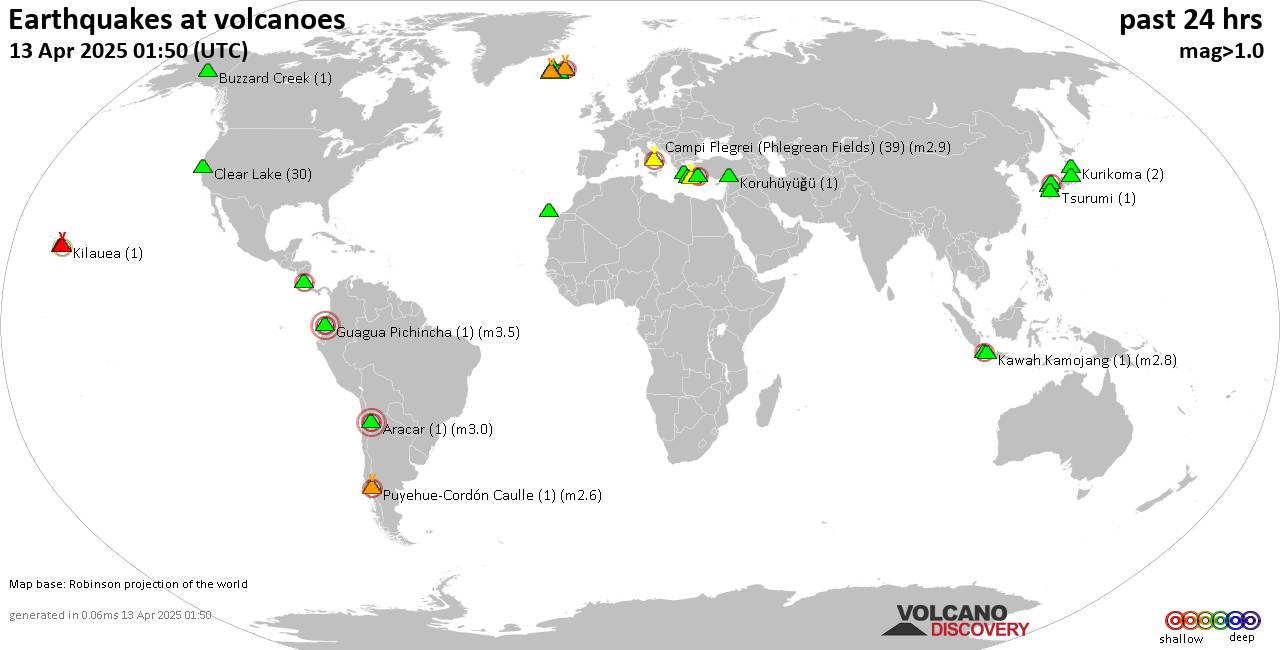
World map showing volcanoes with shallow (less than 50 km) earthquakes within 20 km radius during the past 24 hours on 13 Apr 2025 Number in brackets indicate nr of quakes.

Quakes detected near: Abu (9 quakes between mag 0.3-1.4), Akita-Komagatake (3 quakes between mag 0.6-1.6), Aracar (2 quakes between mag 3.0-3.0), Babuyan Claro (1 quake mag 2.9), Bardarbunga (5 quakes between mag 0.3-1.6), Campi Flegrei (Phlegrean Fields) (20 quakes between mag 0.1-1.5)
Clear Lake (43 quakes between mag 0.1-1.7), Conchagüita (2 quakes between mag 2.3-2.6), Coso (4 quakes between mag 0.8-1.1), Eldey (1 quake mag 1.5), Eyafjallajökull (1 quake mag 1.4), Fagradalsfjall (10 quakes between mag 0.6-3.3), Galunggung (1 quake mag 2.3), Hakone (1 quake mag 1.1), Hrómundartindur (2 quakes between mag 0.5-1.3), Karapinar (1 quake mag 1.6), Katla (2 quakes between mag 0.9-2.1), Kilauea (3 quakes between mag 1.8-2.5), Kolumbo (11 quakes between mag 1.1-2.8), Koruhüyüğü (1 quake mag 1.4), Krafla (1 quake mag 1.4), Krísuvík (3 quakes between mag 0.9-1.9), Kuju (1 quake mag 1.6), Loki-Fögrufjöll volcano (1 quake mag 1.3), Mahagnao (1 quake mag 1.8), Martin (1 quake mag 1.7), Mayotte Island (1 quake mag 1.1), Megata (3 quakes between mag 1.3-1.7), Niigata-Yake-yama (1 quake mag 1.0), Nisyros (1 quake mag 2.6), Osore-yama (1 quake mag 1.5), Prestahnukur (1 quake mag 1.6),

Click this link to continue reading the article on the source website.