RSS feed source: Federal Emergency Management Agency

CHARLESTON, W.Va. – The FEMA-West Virginia Disaster Recovery Center in Raleigh County is closing permanently Friday, May 2, 2025, at 6 p.m.

The center is located at: 

Raleigh County Disaster Recovery Center

Beckley-Raleigh County Emergency Services

1224 Airport Road

Beaver WV 25813

Hours of operation:

Monday to Friday: 8 a.m. to 6 p.m.

Closing permanently at 6 p.m., Friday, May 2, 2025

PLEASE NOTE: While the deadline to apply for FEMA assistance was April 28, centers are staying open past that date to allow residents to visit and check on their statuses, add required documents or appeal decisions.

Residents of Logan, McDowell, Mercer, Mingo, Raleigh, Wayne and Wyoming counties can continue to visit recovery centers in McDowell, Mingo and Wyoming counties to talk face-to-face with FEMA staff. Center information is below:

McDowell County Disaster Recovery Center Mingo County Disaster Recovery Center

Bradshaw Town Hall

10002 Marshall Hwy

Bradshaw, WV 24817

Hours of operation:

Monday to Friday: 8 a.m. to 6 p.m.

Closed weekends

Williamson Campus

1601 Armory Drive

Williamson, WV 25661

Hours of operation:

Monday to Friday: 8 a.m. to 6 p.m.

Closed weekends

Wyoming County Disaster Recovery Center 

Wyoming Court House

24 Main Ave

Pineville, WV 24874

Hours of operation:

Monday to Friday: 8 a.m. to 6 p.m.

Closed weekends


DRCs are accessible to all, including survivors with mobility issues, impaired vision, and those who are who are Deaf or Hard of Hearing.

Residents who live in one of the seven designated counties can visit any Disaster Recovery Center, regardless of the county it is in. Residents can

Click this link to continue reading the article on the source website.

RSS feed source: Federal Emergency Management Agency

Wed, 30 Apr 2025, 13:50 | BY: EARTHQUAKEMONITOR

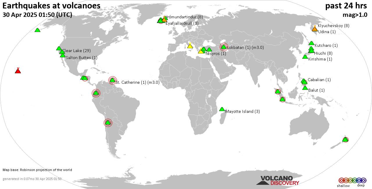
World map showing volcanoes with shallow (less than 50 km) earthquakes within 20 km radius during the past 24 hours on 30 Apr 2025 Number in brackets indicate nr of quakes.

Quakes detected near: Abu (39 quakes between mag 0.1-1.2), Akita-Komagatake (1 quake mag 1.6), Aracar (1 quake mag 3.0), Bardarbunga (12 quakes between mag 0.3-2.0), Biliran (1 quake mag 2.5), Cabalian (2 quakes between mag 2.0-2.7)
Campi Flegrei (Phlegrean Fields) (10 quakes between mag 0.1-1.4), Clear Lake (22 quakes between mag 0.2-1.8), Comondu-La Purisima (1 quake mag 1.9), Coso (2 quakes between mag 1.0-1.0), Eldey (3 quakes between mag 1.0-1.2), Fagradalsfjall (6 quakes between mag 0.2-1.1), Gagak (1 quake mag 2.2), Grímsvötn (3 quakes between mag 0.5-1.0), Hasan Dagi (1 quake mag 1.0), Hiuchi (10 quakes between mag 0.1-1.0), Hrómundartindur (4 quakes between mag 0.3-2.1), Jan Mayen (1 quake mag 1.3), Kilauea (1 quake mag 1.9), Kirishima (3 quakes between mag 0.1-1.6), Klyuchevskoy (5 quakes between mag 1.0-2.0), Kolumbo (11 quakes between mag 0.0-2.1), Koryaksky (1 quake mag 2.2), Krísuvík (3 quakes between mag 0.4-1.4), Ljósufjöll (2 quakes between mag 0.8-1.1), Long Valley (2 quakes between mag 0.7-1.4), Maunaloa (1 quake mag 1.7), Mayotte Island (2 quakes between mag 1.1-1.3), Nasu (3 quakes between mag 0.7-1.2), Nii-jima (1 quake mag 1.1), Nisyros (1 quake mag

Click this link to continue reading the article on the source website.
RSS feed source: Federal Emergency Management Agency

Date and TimeMag
DepthDistanceLocationDetailsMap Apr 29, 05:11 pm (Port Moresby)

4.9

100 km100 km (62 mi) to the SW 61 km northwest of Lae, Morobe, Papua New GuineaI FELT IT2 reportsInfoApr 24, 09:44 pm (Port Moresby)

4.8

104 km89 km (55 mi) to the S 68 km northeast of Lae, Morobe, Papua New GuineaI FELT IT2 reportsInfoApr 22, 11:29 pm (Port Moresby)

5.7

225 km32 km (20 mi) to the W Bismarck Sea, 24 km southwest of Long Island, Madang Province, Papua New GuineaI FELT IT22 reportsInfoApr 18, 12:57 pm (Port Moresby)

4.5

62 km118 km (73 mi) to the SE Solomon Sea, 33 km north of Finschhafen, Morobe, Papua New Guinea InfoApr 12, 08:24 am (Port Moresby)

5.0

128 km80 km (50 mi) to the W 95 km ESE of Madang, Papua New Guinea 3 reportsInfoMar 16, 02:28 am (Port Moresby)

5.1

59 km79 km (49 mi) to the SE 94 km northeast of Lae, Morobe, Papua New Guinea InfoMar 14, 2023 10:49 am (Port Moresby)

6.3

213 km50 km (31 mi) to the W 118 km E of Madang, Papua New Guinea 39 reportsInfoSep 11, 2022 09:47 am (Port Moresby)

7.6

116 km124 km (77 mi) to the SW 72 km northwest of Lae, Morobe, Papua New Guinea 166 reportsInfoJul 17, 2020 12:50 pm (Port Moresby)

7.0

73 km267 km (166 mi) to the S 114 km NNW of Popondetta, Papua New Guinea 216 reportsInfoMay 7, 2019 07:19 am (Port Moresby)

7.0

133 km188 km (117 mi) to the SW Eastern New Guinea Reg., P.N.G. 37 reportsInfoNov 7, 2014 01:33 pm (Port

Click this link to continue reading the article on the source website.

RSS feed source: Federal Emergency Management Agency

<!–div style="font-size:14px;text-align:center;border:3px solid blue;border-radius:5px;padding:3px;margin:5px;background:#eee"><a href="https://www.volcanoesandearthquakes.com/app/volcano-report.php?volcanoId=114" style="text-decoration:none" target="_blank" rel="noopener noreferrer nofollow" title="Share a volcano (activity) report, submit a photo or other interesting news!” onclick=”window.open(this.href,’Volcano Report’,’status=0,toolbar=0,location=0,directories=0,menubar=0,resizable=1,scrollbars=1,height=500,width=450′);return false”>Send Volcano Report</div–> Stratovolcano 2708 m (8,884 ft)
Costa Rica, 10.2°N / -84.23°W
Current status: erupting (4 out of 5) Poas volcano eruptions:
1828, 1834, 1838(?), 1860, 1879(?), 1880, 1888-91, 1895, 1898-1907, 1910, 1910, 1914, 1914-15, 1925, 1929, 1941-46, 1948-51, 1952-57, 1958-61, 1963, 1964-65, 1967, 1969, 1970, 1972-73, 1974-75, 1976, 1977, 1977-78, 1978, 1979-80, 1980, 1981, 1987-90, 1991, 1992, 1992-93, 1994, 1996, 2010, 2011, 2012, 2013, 2014, 2016, 2017, 2025
Typical eruption style
Phreatic eruptions, sometimes geyser-like ejections of water from the acid crater lake.

Click this link to continue reading the article on the source website.