RSS feed source: Volcano Discovery.com

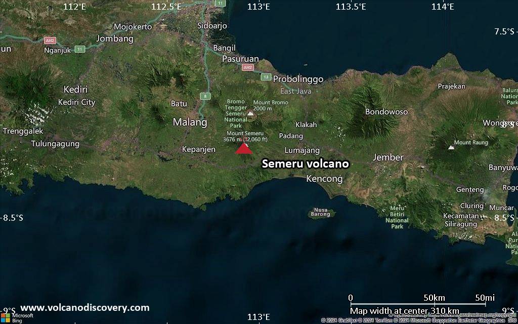
<!–div style="font-size:14px;text-align:center;border:3px solid blue;border-radius:5px;padding:3px;margin:5px;background:#eee"><a href="https://www.volcanoesandearthquakes.com/app/volcano-report.php?volcanoId=44" style="text-decoration:none" target="_blank" rel="noopener noreferrer nofollow" title="Share a volcano (activity) report, submit a photo or other interesting news!” onclick=”window.open(this.href,’Volcano Report’,’status=0,toolbar=0,location=0,directories=0,menubar=0,resizable=1,scrollbars=1,height=500,width=450′);return false”>Send Volcano Report</div–> Stratovolcano 3676 m (12,060 ft)
East Java, Indonesia, -8.11°S / 112.92°E
Current status: erupting (4 out of 5) Semeru volcano eruptions:
1818, 1829, 1830, 1832, 1836, 1838, 1842, 1844, 1845, 1848, 1849(?), 1851, 1856, 1857, 1865, 1866(?), 1887, 1887, 1888, 1889-91, 1892, 1893, 1893-94, 1895, 1896, 1897, 1899, 1899, 1900, 1901, 1903, 1904, 1905, 1907, 1908, 1909-10, 1910-11, 1911, 1912, 1913, 1941-42, 1945, 1946, 1946-47, 1950-64, 1967-ongoing
Typical eruption style
Explosive. Near constant strombolian activity, occasionally stronger explosions, lava flows and pyroclastic flows.

Click this link to continue reading the article on the source website.
RSS feed source: Volcano Discovery.com

Date and TimeMag
DepthDistanceLocationDetailsMap Jun 18, 02:10 am (Jayapura)

4.7

5 km29 km (18 mi) to the E Kabupaten Yahukimo, South Papua, 59 km southeast of Wamena, IndonesiaI FELT IT InfoJun 7, 04:05 am (Jayapura)

4.2

10 km49 km (30 mi) to the E Kabupaten Yahukimo, South Papua, 65 km southeast of Wamena, Indonesia InfoMay 31, 05:24 pm (Jayapura)

4.2

10 km41 km (26 mi) to the E Kabupaten Yahukimo, South Papua, 59 km southeast of Wamena, Indonesia InfoApr 28, 04:36 am (Jayapura)

3.6

112 km33 km (20 mi) to the NE Kabupaten Yahukimo, South Papua, 31 km southeast of Wamena, Indonesia

Info

Apr 20, 06:49 am (Jayapura)

4.3

10 km85 km (53 mi) to the N Kabupaten Yalimo, South Papua, 55 km northeast of Wamena, Indonesia InfoApr 12, 10:51 am (Jayapura)

4.6

10 km47 km (29 mi) to the W Kabupaten Nduga, South Papua, 59 km southwest of Wamena, Indonesia InfoMar 1, 2024 04:06 pm (Jayapura)

5.3

10 km59 km (37 mi) to the SE Kabupaten Yahukimo, South Papua, 274 km southwest of Jayapura, Indonesia InfoNov 16, 2023 11:21 am (Jayapura)

5.1

93 km89 km (55 mi) to the NW 203 km NNE of Agats, Indonesia InfoApr 1, 2022 08:18 am (Jayapura)

5.2

10 km55 km (34 mi) to the SE Kabupaten Yahukimo, South Papua, 291 km southwest of Jayapura, Indonesia InfoMar 12, 2021 10:18 am (Jayapura)

5.2

10 km88 km (54 mi) to the W Papua, Indonesia InfoMar 12, 2021 01:16 am (Universal Time)

5.4

10 km64 km (40 mi) to the W Kabupaten Nduga, Highland Papua, 104 km northeast of Agats, Indonesia InfoJan 28, 2019 01:03 pm (Universal Time)

5.2

10 km143 km (89 mi) to the N Kabupaten Jayapura,

Click this link to continue reading the article on the source website.

RSS feed source: Volcano Discovery.com

Date and TimeMag
DepthDistanceLocationDetailsMap Jun 15, 05:07 am (Taipei)

4.2

15 km89 km (55 mi) to the NE 62 km southwest of Hualien City, TaiwanI FELT IT InfoJun 7, 07:09 pm (Taipei)

4.0

17 km2.4 km (1.5 mi) to the NE 33 km northeast of Yongkang, Taiwan InfoMay 14, 10:48 am (Taipei)

4.0

10 km16 km (9.7 mi) to the N 20 km south of Chiayi City, Taiwan 1 reportInfoMay 13, 03:37 am (Taipei)

4.0

11 km90 km (56 mi) to the E Philippine Sea, 33 km northeast of Taitung, Taiwan 1 reportInfoMay 10, 05:27 am (Taipei)

4.3

20 km72 km (45 mi) to the N Taiwan InfoJan 21, 12:17 am (Taipei)

6.0

16 km3.8 km (2.3 mi) to the E 39 km northeast of Tainan, Taiwan 79 reportsInfoApr 3, 2024 07:58 am (Taipei)

7.4

40 km133 km (83 mi) to the NE Philippine Sea, 16 km south of Hualien City, Taiwan 232 reportsInfoSep 18, 2022 05:39 pm (Taipei)

5.9

10 km80 km (50 mi) to the E 53 km north of Taitung, Taiwan 1 reportInfoSep 18, 2022 02:44 pm (Taipei)

6.9

10 km85 km (53 mi) to the E 90 km E of Yujing, Taiwan 42 reportsInfoSep 17, 2022 09:41 pm (Taipei)

6.5

10 km93 km (58 mi) to the E Philippine Sea, 49 km northeast of Taitung, Taiwan 65 reportsInfoFeb 6, 2016 03:57 am (Taipei)

6.2

32 km45 km (28 mi) to the SE Kaohsiung, 39 km west of Taitung, Taiwan 59 reportsInfoJun 2, 2013 01:43 pm (Taipei)

6.2

17 km94 km (59 mi) to the NE 26 km SE of Puli, Taiwan 24 reportsInfoFeb 26, 2012 10:35 am (Taipei)

5.9

28 km69 km (43 mi) to the SE 50 km ENE of Donggang, Taiwan

Click this link to continue reading the article on the source website.

RSS feed source: Volcano Discovery.com

Date and TimeMag
DepthDistanceLocationDetailsMap Jun 11, 12:46 am (GMT +9)

4.7

183 km91 km (57 mi) to the SE Banda Sea, 120 km north of Pulau Wetan Island, Maluku, Indonesia InfoJun 3, 05:45 am (Jayapura)

4.9

163 km89 km (55 mi) to the SE Banda Sea, 102 km north of Pulau Wetan Island, Maluku, Indonesia InfoJun 3, 01:15 am (GMT +9)

4.2

282 km99 km (62 mi) to the SW Banda Sea, 144 km northeast of Pulau Romang Island, Maluku, Indonesia InfoJun 2, 01:14 pm (GMT +9)

4.3

27 km88 km (55 mi) to the N Banda Sea, 219 km southeast of Ambon, Kota Ambon, Maluku, Indonesia InfoMay 31, 08:42 pm (Jayapura)

4.3

94 km90 km (56 mi) to the E Banda Sea InfoApr 5, 02:57 pm (GMT +9)

4.7

312 km94 km (58 mi) to the N Banda Sea, 244 km southeast of Ambon, Kota Ambon, Maluku, Indonesia InfoMar 19, 10:46 am (GMT +9)

4.9

162 km92 km (57 mi) to the SE Banda Sea, 139 km north of Pulau Wetan Island, Maluku, Indonesia InfoMar 11, 07:10 pm (Jayapura)

4.7

164 km82 km (51 mi) to the SE Banda Sea, 125 km north of Pulau Wetan Island, Maluku, Indonesia InfoNov 8, 2023 10:02 pm (Jayapura)

6.7

10 km78 km (49 mi) to the E Banda Sea, 201 km north of Pulau Wetan Island, Maluku, Indonesia 1 reportInfoNov 8, 2023 01:53 pm (GMT +9)

7.1

6 km44 km (27 mi) to the E Banda Sea InfoNov 8, 2023 01:52 pm (GMT +9)

6.7

10 km66 km (41 mi) to the E Banda Sea, 164 km north of Pulau Wetan Island, Maluku, Indonesia 7 reportsInfoMay 25, 2023 12:49 am

Click this link to continue reading the article on the source website.