RSS feed source: USGS Earthquake Hazards Program
Time2025-06-17 13:45:23 UTC2025-06-17 13:45:23 UTC at epicenterLocation38.913°N 70.798°EDepth10.00 km (6.21 mi)
Click this link to continue reading the article on the source website.
RSS feed source: USGS Earthquake Hazards Program
Time2025-06-17 13:45:23 UTC2025-06-17 13:45:23 UTC at epicenterLocation38.913°N 70.798°EDepth10.00 km (6.21 mi)
Click this link to continue reading the article on the source website.
RSS feed source: USGS Earthquake Hazards Program
Tue, 17 Jun 2025, 14:50 | BY: EARTHQUAKEMONITOR
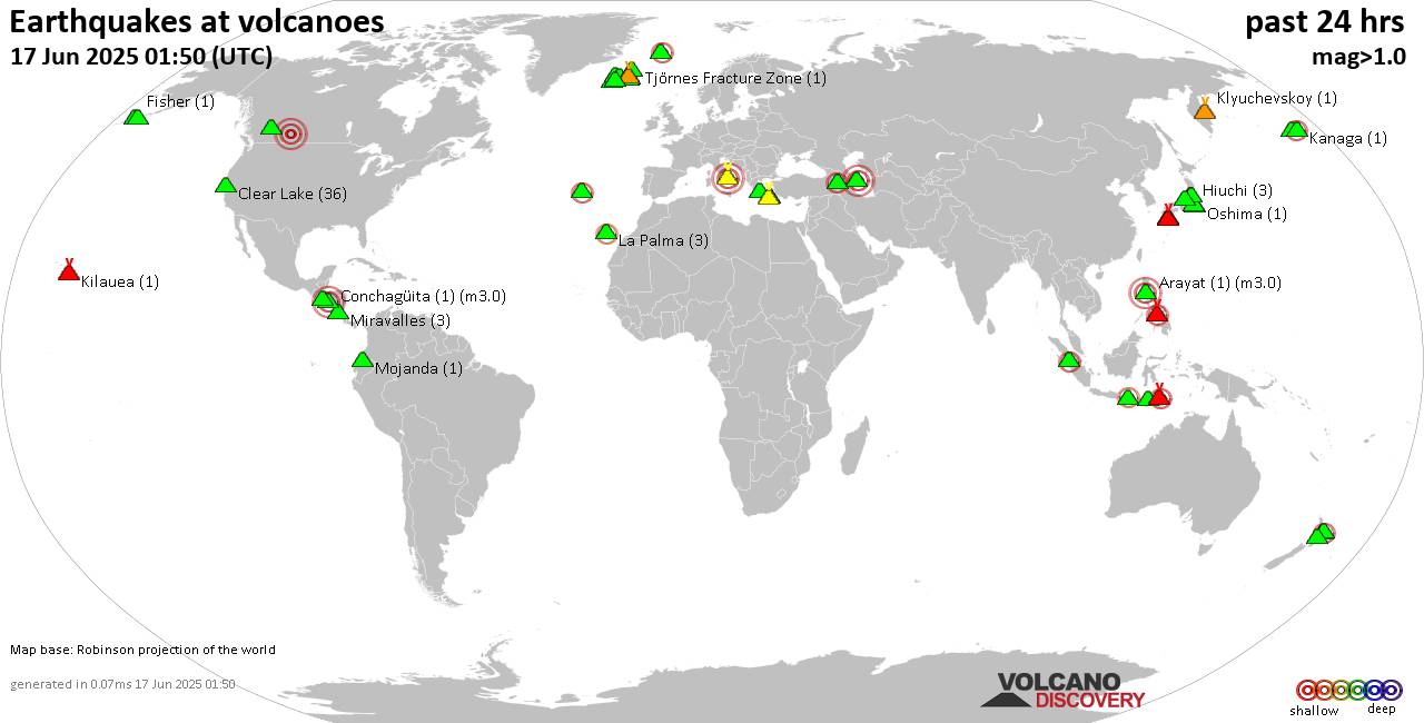
World map showing volcanoes with shallow (less than 50 km) earthquakes within 20 km radius during the past 24 hours on 17 Jun 2025 Number in brackets indicate nr of quakes.
Quakes detected near: Akita-Yake-yama (2 quakes between mag 0.4-1.1), Aso (4 quakes between mag 0.6-1.3), Bardarbunga (5 quakes between mag 0.5-2.2), Barva (1 quake mag 3.0), Brennisteinsfjöll (2 quakes between mag 0.3-1.0), Campi Flegrei (Phlegrean Fields) (9 quakes between mag 0.1-3.0)
Canlaon (2 quakes between mag 2.0-2.1), Clear Lake (27 quakes between mag 0.0-1.8), E-san (1 quake mag 3.0), El Chichón (1 quake mag 2.4), Eldey (1 quake mag 1.1), Fisher (2 quakes between mag 1.6-1.8), Furnas (9 quakes between mag 2.0-3.7), Golden Trout Creek (4 quakes between mag 1.2-2.1), Grímsvötn (5 quakes between mag 0.4-1.1), Hiuchi (4 quakes between mag 0.5-1.0), Izu-Tobu (1 quake mag 1.0), Jan Mayen (2 quakes between mag 1.3-1.9), Klyuchevskoy (3 quakes between mag 1.2-1.9), Kolumbo (5 quakes between mag 1.5-2.7), Kurikoma (3 quakes between mag 0.2-1.1), La Palma (2 quakes between mag 2.0-2.3), Laacher See (1 quake mag 1.4), Lewotolo (2 quakes between mag 2.0-2.1), Ljósufjöll (15 quakes between mag 0.2-2.9), Loki-Fögrufjöll volcano (2 quakes between mag 0.8-1.5), Miravalles (1 quake mag 1.5), Mojanda (1 quake mag 1.9), Okataina (Tarawera) (1 quake mag 1.8), Oshima (1 quake mag 1.0),
Click this link to continue reading the article on the source website.
RSS feed source: USGS Earthquake Hazards Program
Date and TimeMag
DepthDistanceLocationDetailsMap Mar 14, 06:37 pm (GMT +2)
4.5
6.2 km54 km (34 mi) to the W Eastern Mediterranean, 53 km west of Nisi Gavdos Island, Chania, Crete, Greece 11 reportsInfoJan 28, 09:40 pm (Athens)
4.0
10 km35 km (22 mi) to the E26 km SW of Agía Galíni, Greece 9 reportsInfoJan 3, 01:58 pm (GMT +2)
4.0
5.6 km69 km (43 mi) to the W Eastern Mediterranean, 68 km west of Nisi Gavdos Island, Chania, Crete, Greece InfoDec 28, 2024 08:30 am (GMT +2)
4.1
50 km41 km (26 mi) to the W32 km S of Palaióchora, Greece InfoSep 11, 2024 10:07 am (GMT +2)
4.3
45 km44 km (27 mi) to the S39 km SSW of Kastrí, Greece InfoAug 28, 2024 07:29 pm (Athens)
5.2
14 km11 km (7.1 mi) to the E Eastern Mediterranean, 14 km northeast of Nisi Gavdos Island, Greece 396 reportsInfoAug 26, 2024 05:37 am (Athens)
4.5
10 km23 km (14 mi) to the SW Eastern Mediterranean, 20 km southwest of Nisi Gavdos Island, Greece InfoAug 13, 2024 03:35 am (GMT +2)
4.3
4.6 km76 km (47 mi) to the E Eastern Mediterranean, 55 km south of Crete Island, Crete, Greece 33 reportsInfoJul 21, 2024 07:01 am (GMT +3)
5.3
17 km81 km (50 mi) to the W Eastern Mediterranean, 80 km west of Nisi Gavdos Island, Chania, Crete, Greece 22 reportsInfoDec 29, 2021 08:08 am (Athens)
5.7
67 km95 km (59 mi) to the E Eastern Mediterranean, 60 km south of Irakleion, Greece 210 reportsInfoJul 31, 2017 11:29 pm (GMT +2)
5.2
28 km37 km (23 mi) to the S Eastern Mediterranean, 34 km south of Nisi Gavdos Island,
Click this link to continue reading the article on the source website.
RSS feed source: USGS Earthquake Hazards Program
Support us – Help us upgrade our services! We truly love working to bring you the latest volcano and earthquake data from around the world. Maintaining our website and our free apps does require, however, considerable time and resources.
We need financing to increase hard- and software capacity as well as support our editor team. We’re aiming to achieve uninterrupted service wherever an earthquake or volcano eruption unfolds, and your donations can make it happen! Every donation will be highly appreciated. If you find the information useful and would like to support our team in integrating further features, write great content, and in upgrading our soft- and hardware, please make a donation (PayPal).
Planned features:
Improved multilanguage supportTsunami alertsFaster responsivenessThanks to your past donations, these features have been added recently:Design upgradeDetailed quake statsAdditional seismic data sourcesDownload and Upgrade the Volcanoes & Earthquakes app to get one of the fastest seismic and volcano alerts online:
Android | IOSThank you!
Click this link to continue reading the article on the source website.