RSS feed source: Volcano Discovery.com--Global earthquake monitor

Tue, 29 Apr 2025, 00:50 | BY: EARTHQUAKEMONITOR

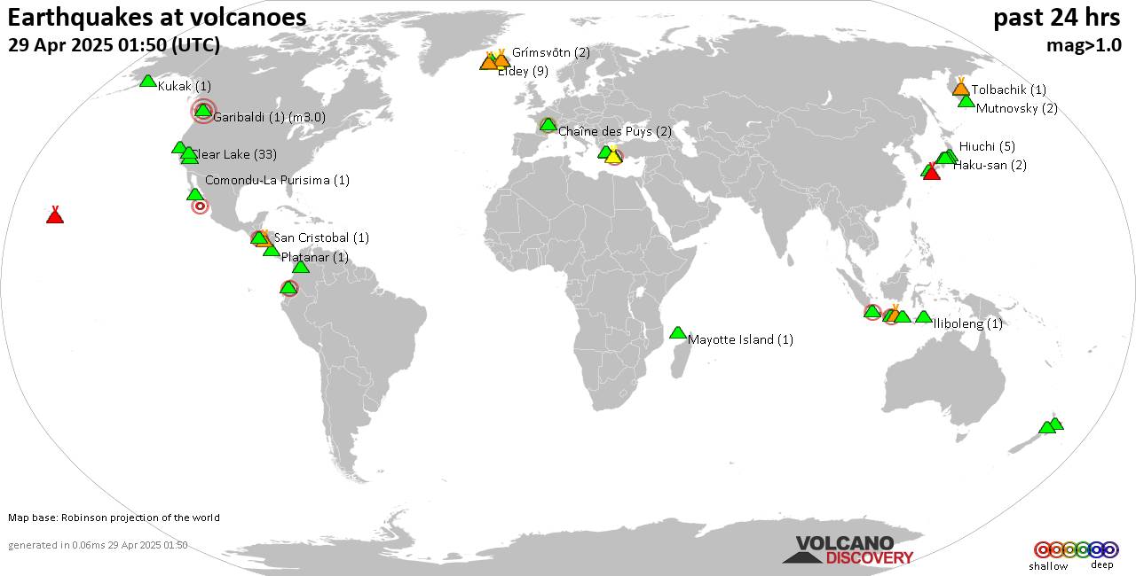
World map showing volcanoes with shallow (less than 50 km) earthquakes within 20 km radius during the past 24 hours on 29 Apr 2025 Number in brackets indicate nr of quakes.

Quakes detected near: Bardarbunga (17 quakes between mag 0.0-1.0), Chaîne des Puys (2 quakes between mag 1.1-2.3), Clear Lake (34 quakes between mag 0.2-1.9), Comondu-La Purisima (1 quake mag 2.3), Coso (4 quakes between mag 1.3-1.7), Eldey (8 quakes between mag 0.8-2.2)
Gagak (2 quakes between mag 1.8-2.2), Garibaldi (1 quake mag 3.0), Grímsvötn (2 quakes between mag 0.3-1.0), Guagua Pichincha (1 quake mag 2.6), Haku-san (2 quakes between mag 0.6-1.1), Hiuchi (5 quakes between mag 0.4-1.5), Iliboleng (1 quake mag 1.4), Katla (4 quakes between mag 0.4-1.0), Kilauea (2 quakes between mag 1.7-1.7), Kita Yatsugatake (1 quake mag 1.1), Klyuchevskoy (6 quakes between mag 1.1-2.0), Kolumbo (9 quakes between mag 1.7-2.3), Kukak (1 quake mag 1.4), Ljósufjöll (7 quakes between mag 0.5-2.3), Malang Plain (1 quake mag 2.4), Mammoth Mountain (1 quake mag 1.2), Mayotte Island (1 quake mag 1.4), Methana (1 quake mag 3.8), Mutnovsky (2 quakes between mag 0.7-1.0), Platanar (1 quake mag 1.1), Raung (1 quake mag 2.2), Reporoa (2 quakes between mag 1.1-1.6), Rinjani (1 quake mag 1.9), Sakurajima (1 quake mag 1.0), San Cristobal (1 quake mag 1.6), San

Click this link to continue reading the article on the source website.

RSS feed source: Volcano Discovery.com--Global earthquake monitor

Date and TimeMag
DepthDistanceLocationDetailsMap Apr 19, 01:15 pm (GMT +12)

4.4

33 km34 km (21 mi) to the NE South Pacific Ocean, Hawke’s Bay, 174 km west of Raoul Island, New Zealand InfoApr 11, 03:11 am (GMT +12)

4.2

303 km79 km (49 mi) to the SE New Zealand InfoMar 25, 09:35 am (GMT +13)

4.1

240 km68 km (42 mi) to the S South Pacific Ocean, 236 km southwest of Raoul Island, New Zealand InfoJan 8, 11:54 pm (GMT +12)

4.8

226 km64 km (40 mi) to the SE South Pacific Ocean, Bay of Plenty, 211 km southwest of Raoul Island, New Zealand InfoJan 2, 09:15 am (GMT +12)

4.6

211 km58 km (36 mi) to the NE South Pacific Ocean, 145 km west of Raoul Island, New Zealand InfoMay 15, 2024 03:15 pm (GMT +12)

5.3

366 km60 km (37 mi) to the SE South Pacific Ocean, 191 km southwest of Raoul Island, New Zealand InfoMar 5, 2021 08:19 pm (GMT +12)

5.3

33 km43 km (27 mi) to the S New Zealand InfoMar 5, 2021 07:28 am (GMT +12)

8.1

29 km253 km (157 mi) to the E South Pacific Ocean, 81 km southeast of Raoul Island, New Zealand 15 reportsInfoSep 4, 2019 06:46 pm (GMT +12)

5.1

33 km91 km (56 mi) to the N South Pacific Ocean, 191 km west of Raoul Island, New Zealand InfoJun 27, 2019 11:04 am (Universal Time)

5.3

10 km93 km (58 mi) to the SESouth Pacific Ocean, 173 km southwest of Raoul Island, New Zealand 1 reportInfoJun 16, 2019 10:55 am (GMT +12)

7.3

46 km191 km (118 mi) to the SE Kermadec Islands, New Zealand 10

Click this link to continue reading the article on the source website.

RSS feed source: Volcano Discovery.com--Global earthquake monitor

<!–div style="font-size:14px;text-align:center;border:3px solid blue;border-radius:5px;padding:3px;margin:5px;background:#eee"><a href="https://www.volcanoesandearthquakes.com/app/volcano-report.php?volcanoId=44" style="text-decoration:none" target="_blank" rel="noopener noreferrer nofollow" title="Share a volcano (activity) report, submit a photo or other interesting news!” onclick=”window.open(this.href,’Volcano Report’,’status=0,toolbar=0,location=0,directories=0,menubar=0,resizable=1,scrollbars=1,height=500,width=450′);return false”>Send Volcano Report</div–> Stratovolcano 3676 m (12,060 ft)
East Java, Indonesia, -8.11°S / 112.92°E
Current status: erupting (4 out of 5) Semeru volcano eruptions:
1818, 1829, 1830, 1832, 1836, 1838, 1842, 1844, 1845, 1848, 1849(?), 1851, 1856, 1857, 1865, 1866(?), 1887, 1887, 1888, 1889-91, 1892, 1893, 1893-94, 1895, 1896, 1897, 1899, 1899, 1900, 1901, 1903, 1904, 1905, 1907, 1908, 1909-10, 1910-11, 1911, 1912, 1913, 1941-42, 1945, 1946, 1946-47, 1950-64, 1967-ongoing
Typical eruption style
Explosive. Near constant strombolian activity, occasionally stronger explosions, lava flows and pyroclastic flows.

Click this link to continue reading the article on the source website.

RSS feed source: Volcano Discovery.com--Global earthquake monitor

Support us – Help us upgrade our services! We truly love working to bring you the latest volcano and earthquake data from around the world. Maintaining our website and our free apps does require, however, considerable time and resources.
We need financing to increase hard- and software capacity as well as support our editor team. We’re aiming to achieve uninterrupted service wherever an earthquake or volcano eruption unfolds, and your donations can make it happen! Every donation will be highly appreciated. If you find the information useful and would like to support our team in integrating further features, write great content, and in upgrading our soft- and hardware, please make a donation (PayPal).

Planned features:

Improved multilanguage supportTsunami alertsFaster responsivenessThanks to your past donations, these features have been added recently:Design upgradeDetailed quake statsAdditional seismic data sourcesDownload and Upgrade the Volcanoes & Earthquakes app to get one of

Click this link to continue reading the article on the source website.