RSS feed source: US National Weather Service

…The Flood Warning continues for the following rivers in Oregon… Silvies River Near Burns affecting Harney County. .Continued snowmelt will keep the river at or near flood stage into next week. For the Silvies River…including Burns…flooding is forecast to continue. * WHAT…Flooding is occurring and flooding is forecast. * WHERE…Silvies River near Burns. * WHEN…Until further notice. * IMPACTS…Flooding is occurring and affecting roads and homes. * ADDITIONAL DETAILS… – At 1:00 AM PDT Sunday the stage was 12.3 feet. – Bankfull stage is 10.5 feet. – Recent Activity…The maximum river stage in the 24 hours ending at 1:00 AM PDT Sunday was 12.8 feet. – Forecast…The river will remain above

Click this link to continue reading the article on the source website.

RSS feed source: US National Weather Service

Sun, 13 Apr 2025, 07:50 | BY: EARTHQUAKEMONITOR

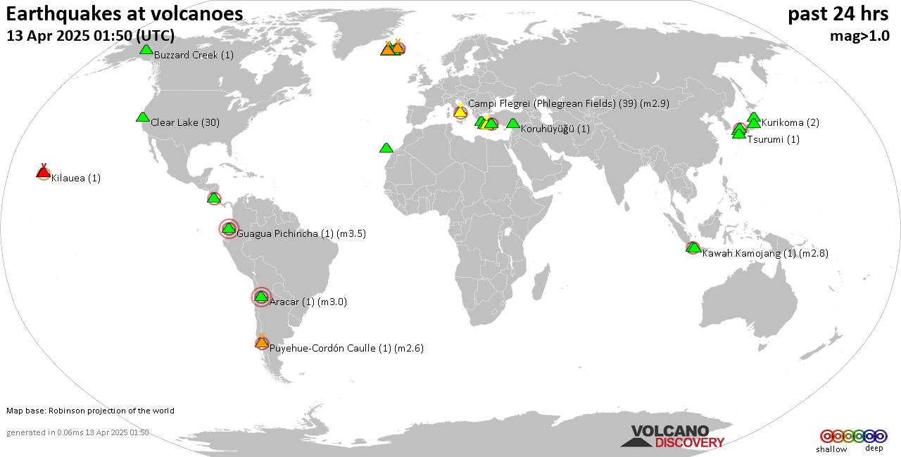
World map showing volcanoes with shallow (less than 50 km) earthquakes within 20 km radius during the past 24 hours on 13 Apr 2025 Number in brackets indicate nr of quakes.

Quakes detected near: Abu (5 quakes between mag 0.3-1.1), Akyarlar (1 quake mag 2.4), Aracar (3 quakes between mag 3.0-3.0), Bardarbunga (5 quakes between mag 0.4-2.3), Campi Flegrei (Phlegrean Fields) (45 quakes between mag 0.1-2.9), Clear Lake (33 quakes between mag 0.2-1.4)
Cofre de Perote (1 quake mag 3.3), Conchagüita (1 quake mag 2.3), Eldey (1 quake mag 1.8), Eyafjallajökull (1 quake mag 1.4), Fagradalsfjall (10 quakes between mag 0.3-1.8), Gede-Pangrango (1 quake mag 2.1), Hrómundartindur (3 quakes between mag 0.5-1.1), Kilauea (2 quakes between mag 2.2-2.5), Kolumbo (20 quakes between mag 1.3-2.8), Koruhüyüğü (1 quake mag 1.4), Krísuvík (4 quakes between mag 0.2-2.6), Kurikoma (3 quakes between mag 0.7-1.2), Ljósufjöll (16 quakes between mag 0.8-2.4), Megata (1 quake mag 1.3), Methana (1 quake mag 2.1), Nantai (1 quake mag 1.2), Prestahnukur (1 quake mag 1.6), San Cristobal (1 quake mag 1.5), Sanbe (1 quake mag 2.0), Santorini (5 quakes between mag 1.0-2.1), Svartsengi (4 quakes between mag 1.0-1.1), Tenerife (1 quake mag 1.7), Tenorio (1 quake mag 2.7), Tsurumi (1 quake mag 1.1), Veniaminof (2 quakes between mag 2.1-2.2) (updated 07h50)

Note: Earthquakes within

Click this link to continue reading the article on the source website.
RSS feed source: US National Weather Service

Date and TimeMag
DepthDistanceLocationDetailsMap Apr 13, 10:06 am (Dushanbe)

4.2

10 km39 km (24 mi) to the SE 40 km southeast of Rasht, Districts of Republican Subordination, TajikistanI FELT IT InfoApr 13, 09:24 am (Dushanbe)

5.8

10 km31 km (19 mi) to the SE 32 km southeast of Rasht, Districts of Republican Subordination, TajikistanI FELT IT114 reportsInfoApr 7, 03:44 am (Dushanbe)

4.0

22 km48 km (30 mi) to the SE 50 km east of Rasht, Districts of Republican Subordination, TajikistanI FELT IT1 reportInfoMar 25, 05:55 pm (Dushanbe)

4.3

10 km46 km (29 mi) to the SW 15 km northeast of Roghun, Districts of Republican Subordination, Tajikistan InfoDec 22, 2024 12:36 am (Dushanbe)

4.5

10 km39 km (24 mi) to the E 43 km east of Rasht, Districts of Republican Subordination, Tajikistan 1 reportInfoNov 5, 2024 03:13 pm (Dushanbe)

4.7

10 km78 km (48 mi) to the S 59 km ENE of Mŭ’minobod, Tajikistan InfoNov 5, 2024 02:03 pm (Dushanbe)

4.7

10 km75 km (47 mi) to the S Gorno-Badakhshan, 80 km northeast of Kulob, Viloyati Khatlon, Tajikistan InfoMar 31, 2024 05:25 am (Dushanbe)

5.0

10 km39 km (24 mi) to the E Tadzhikistan Territories, Tajikistan 13 reportsInfoDec 10, 2023 09:07 am (Dushanbe)

5.2

10 km42 km (26 mi) to the W TAJIKISTAN InfoMar 23, 2023 01:07 am (Dushanbe)

5.8

12 km57 km (35 mi) to the NW 96 km southeast of Istaravshan, Viloyati Sughd, Tajikistan 612 reportsInfoJul 10, 2021 07:14 am (Dushanbe)

5.7

10 km27 km (17 mi) to the SE 27 km southeast of Rasht, Districts of Republican Subordination, Tajikistan 34 reportsInfoJul 4, 2020 02:53 pm (Dushanbe)

5.4

10 km48 km (30 mi) to the

Click this link to continue reading the article on the source website.