RSS feed source: Volcano Discovery.com--Global earthquake monitor

Thu, 23 Oct 2025, 21:28 | BY: EARTHQUAKEMONITOR

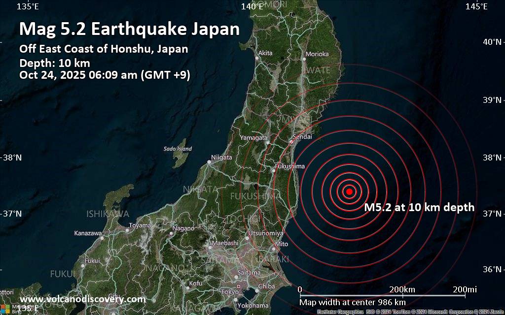
A magnitude 5.2 earthquake near Minami-Soma, Minamisōma Shi, Fukushima, Japan, was reported only 18 minutes ago by the German Research Centre for Geosciences (GFZ), considered one of the key international agencies that monitor seismic activity worldwide. The earthquake occurred at a shallow depth of 10. km beneath the epicenter early morning on Friday, October 24th, 2025, at 6:09 am local time. The exact magnitude, epicenter, and depth of the quake might be revised within the next few hours or minutes as seismologists review data and refine their calculations, or as other agencies issue their report.
A second report was later issued by France’s Réseau National de Surveillance Sismique (RéNaSS), which listed it as a magnitude 5.1 earthquake. Other agencies reporting the same quake include Japan’s National Research Institute for Earth Science and Disaster Resilience (NIED) at magnitude 5.2, and the citizen-seismograph network of RaspberryShake at magnitude 5.2.
Generally quakes of this magnitude are recorded by more than one agency and the results can vary, with subsequent reports that come in after the first one often showing more accuracy.
Based on the preliminary seismic data, the quake should not have caused any significant damage, but was probably felt by many people as light vibration in the area of the epicenter.
Weak shaking might have been felt in Minami-Soma

Click this link to continue reading the article on the source website.

RSS feed source: Volcano Discovery.com--Global earthquake monitor

Support Us – Help Us Enhance Our Services! We’re passionate about delivering the latest volcano and earthquake data from around the globe — just for you. However, maintaining our website and free apps requires significant time, effort, and resources.
Your support helps us expand our hardware and software capabilities and empowers our dedicated editorial team. Our mission is to provide uninterrupted, real-time updates whenever an earthquake strikes or a volcano erupts — and your donations make this possible. Every contribution, big or small, is deeply appreciated. If you find our information valuable and want to help us add new features, create compelling content, and improve our technology, please consider making a donation: Donate with PayPal: Planned Features: Improved multilingual support Tsunami alerts Faster responsiveness Thanks to your past donations, we have recently added: Design upgrades Detailed earthquake

Click this link to continue reading the article on the source website.

RSS feed source: Volcano Discovery.com--Global earthquake monitor

Date and TimeMag
DepthDistanceLocationDetailsMap Oct 22, 03:48 am (GMT +9)

4.4

34 km31 km (19 mi) to the NE 106 km E of Minami-Sōma, Japan  I FELT IT InfoOct 16, 03:57 am (GMT +9)

4.1

10 km89 km (55 mi) to the SW North Pacific Ocean, 54 km southeast of Iwaki, Fukushima, Japan InfoOct 10, 09:25 pm (GMT +9)

4.0

60 km68 km (42 mi) to the N North Pacific Ocean, 64 km southeast of Ishinomaki, Miyagi, Japan InfoOct 10, 09:24 pm (GMT +9)

4.0

55 km69 km (43 mi) to the N Japan: SE Off Miyagi Pref InfoOct 10, 09:24 pm (GMT +9)

4.0

57 km69 km (43 mi) to the N Japan: SE Off Miyagi Pref InfoOct 5, 12:21 am (GMT +9)

6.0

47 km34 km (21 mi) to the W Fukushima, 262 km northeast of Takasaki, Gunma, Japan 224 reportsInfoDec 28, 2024 04:10 am (GMT +9)

5.3

45 km40 km (25 mi) to the W North Pacific Ocean, 72 km northeast of Iwaki, Fukushima, Japan 6 reportsInfoApr 4, 2024 12:16 pm (GMT +9)

6.1

29 km36 km (22 mi) to the NW 77 km E of Minami-Sōma, Japan 68 reportsInfoMar 17, 2024 06:17 am (GMT +9)

5.3

49 km60 km (38 mi) to the SW North Pacific Ocean, 52 km east of Iwaki, Fukushima, Japan 61 reportsInfoMar 15, 2024 12:14 am (GMT +9)

5.6

44 km89 km (55 mi) to the SW 21 km E of Iwaki, Japan 169 reportsInfoMar 16, 2022 11:36 pm (GMT +9)

7.3

41 km52 km (32 mi) to the NW North Pacific Ocean, 67 km south of Tashiro Jima Island, Miyagi, Japan 101 reportsInfoMay 1, 2021 10:27 am (GMT +9)

6.7

61 km95 km

Click this link to continue reading the article on the source website.

RSS feed source: Volcano Discovery.com--Global earthquake monitor

Thu, 23 Oct 2025, 21:00 1761253203 | BY: SEVERAL CONTRIBUTORS

Map of today’s active volcanoes

Svartsengi (Reykjanes peninsula, SW Iceland): The Icelandic Meteorological Office (IMO) reported that by 23 September around 10 million cubic meters of magma had accumulated beneath Svartsengi since the last eruption within the Reykjanes volcanic system ended on 5 August. Data showed that magma was accumulating at around 4 km depth. The rate of magma accumulation was steady; model calculations based on deformation measurements indicated that by 27 September the volume may reach 11 million cubic meters, a volume that in some previous cases was followed by eruptions.
Since the likelihood of an eruption had increased, IMO raised the Volcanic Alert Level System (VAL) to 2 (on a scale of 0-3) on 25 September and concurrently a risk assessment map of the area was also updated.
… [read more]
…22 Oct:
The Icelandic Meteorological Office (IMO)

Click this link to continue reading the article on the source website.