RSS feed source: Volcano Discovery.com--Global earthquake monitor

Date and TimeMag
DepthDistanceLocationDetailsMap Apr 27, 09:09 am (GMT -11)

4.7

35 km27 km (17 mi) to the N North Pacific Ocean, 60 mi southeast of Chuginadak Island, Aleutians West Census Area, Alaska, United StatesI FELT IT InfoApr 27, 11:07 am (GMT -9)

4.6

35 km31 km (19 mi) to the N North Pacific Ocean, 56 mi southeast of Chuginadak Island, Aleutians West Census Area, Alaska, United StatesI FELT IT InfoApr 17, 09:17 am (GMT -9)

4.2

29 km60 km (38 mi) to the SW North Pacific Ocean, 64 mi southeast of Herbert Island, Aleutians West Census Area, Alaska, United States InfoApr 14, 05:26 pm (GMT -9)

4.1

34 km52 km (33 mi) to the W North Pacific Ocean, 61 mi south of Chuginadak Island, Aleutians West Census Area, Alaska, United States InfoApr 12, 06:05 pm (GMT -9)

4.0

10 km55 km (34 mi) to the W North Pacific Ocean, 56 mi south of Chuginadak Island, Aleutians West Census Area, Alaska, United States InfoMay 1, 2024 10:10 pm (GMT -9)

5.4

18 km57 km (35 mi) to the W North Pacific Ocean, 58 mi southeast of Herbert Island, Aleutians West Census Area, Alaska, United States InfoMay 1, 2024 10:06 pm (GMT -9)

5.3

13 km58 km (36 mi) to the SW North Pacific Ocean, 63 mi southeast of Herbert Island, Aleutians West Census Area, Alaska, United States InfoMay 1, 2024 10:01 pm (GMT -9)

5.1

10 km55 km (34 mi) to the SW North Pacific Ocean, 64 mi southeast of Herbert Island, Aleutians West Census Area, Alaska, United States InfoMay 1,

Click this link to continue reading the article on the source website.

RSS feed source: Volcano Discovery.com--Global earthquake monitor

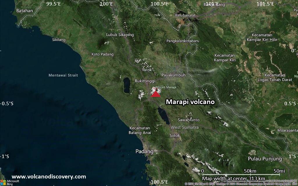
<!–div style="font-size:14px;text-align:center;border:3px solid blue;border-radius:5px;padding:3px;margin:5px;background:#eee"><a href="https://www.volcanoesandearthquakes.com/app/volcano-report.php?volcanoId=62" style="text-decoration:none" target="_blank" rel="noopener noreferrer nofollow" title="Share a volcano (activity) report, submit a photo or other interesting news!” onclick=”window.open(this.href,’Volcano Report’,’status=0,toolbar=0,location=0,directories=0,menubar=0,resizable=1,scrollbars=1,height=500,width=450′);return false”>Send Volcano Report</div–> Stratovolcano 2891 m (9,485 ft)
Western Sumatra, Indonesia, -0.39°S / 100.46°E
Current status: erupting (4 out of 5) Marapi volcano eruptions:
2011-ongoing, 2004 (Aug), 2001, 2000, 1999, 1987-94, 1984, 1984, 1983, 1982, 1980, 1975-79, 1973, 1970-71, 1968(?), 1967, 1966, 1958, 1958, 1954-57, 1950-52, 1949, 1949, 1943, 1932, 1930, 1929, 1927, 1925, 1919, 1918, 1918, 1917, 1916, 1915, 1913, 1911, 1910, 1907-08, 1905, 1904, 1889, 1888, 1886, 1885, 1883, 1878(?), 1883, 1876-77, 1876, 1871, 1871, 1863, 1861, 1855-56, 1854, 1845, 1833-34, 1822, 1807, 1770
Typical eruption style
Small to moderate sized explosions

Click this link to continue reading the article on the source website.
RSS feed source: Volcano Discovery.com--Global earthquake monitor

66 km (41 mi)

NW of epicenter

Culpina K

(pop: 71)

II: Very weak

Departamento de Potosi 69 km (43 mi)

NW of epicenter

San Cristobal

(pop: 75)

II: Very weak

Departamento de Potosi 92 km (57 mi)

NE of epicenter

Atocha

(pop: 1,830)

I: Not felt

Departamento de Potosi 105 km (65 mi)

NE of epicenter

Santa Barbara

(pop: 2,430)

I: Not felt

Departamento de Potosi 105 km (66 mi)

E of epicenter

Tupiza

(pop: 22,200)

I: Not felt

Departamento de Potosi 127 km (79 mi)

SE of epicenter

Villazon

(pop: 30,300)

I: Not felt

Departamento de Potosi 128 km (79 mi)

SE of epicenter

La Quiaca

(pop: 14,800)

I: Not felt

Yavi, Jujuy Province 129 km (80 mi)

N of epicenter

Uyuni

(pop: 10,300)

I: Not felt

Departamento de Potosi 148 km (92 mi)

N of epicenter

Colchani

(pop: 12,000)

I: Not felt

Departamento de Potosi 162 km (100 mi)

SE of epicenter

Abra Pampa

(pop: 9,430)

I: Not felt

Departamento de Cochinoca, Jujuy Province 191 km (119 mi)

NE of epicenter

Camargo

(pop: 4,720)

I: Not felt

Provincia Nor Cinti, Departamento de Chuquisaca 206 km (128 mi)

E of epicenter

Tarija

(pop: 159,300)

I: Not felt

Departamento de Tarija 207 km (129 mi)

SE of epicenter

El Aguilar

(pop:

Click this link to continue reading the article on the source website.