RSS feed source: Global Disaster Alert and Coordination Systems (GDACS).

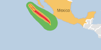
From 04/10/2025 to 04/10/2025, a Tropical Storm (maximum wind speed of 157 km/h) PRISCILLA-25 was active in EastPacific. The cyclone affects these countries: Mexico (vulnerability Medium). Estimated population affected by category 1 (120 km/h) wind speeds or higher is 0 (0 in tropical storm).

Click this link to continue reading the article on the source website.

RSS feed source: Global Disaster Alert and Coordination Systems (GDACS).

Date and TimeMag
DepthDistanceLocationDetailsMap Sep 19, 07:36 am (San Juan)

3.8

120 km41 km (25 mi) to the W San Juan, Argentina

Info

Sep 9, 10:43 pm (GMT -3)

3.2

116 km86 km (54 mi) to the E San Juan, Argentina

Info

Sep 9, 05:56 am (GMT -3)

3.0

129 km93 km (58 mi) to the N San Juan, Argentina

Info

Aug 25, 03:38 am (GMT -3)

3.0

128 km78 km (49 mi) to the N San Juan, Argentina

Info

Jul 23, 06:50 am (GMT -3)

3.0

130 km89 km (55 mi) to the SW Departamento de Calingasta, 170 km northwest of San Juan, Departamento de Capital, San Juan Province, Argentina

Info

Jun 16, 09:22 am (San Juan)

3.9

103 km60 km (37 mi) to the W San Juan, Argentina

Info

May 20, 09:44 am (San Juan)

4.1

10 km23 km (14 mi) to the NW San Juan, Argentina InfoFeb 18, 07:11 pm (San Juan)

4.1

115 km67 km (41 mi) to the NE 22 km north of San Jose de Jachal, Departamento de Jachal, San Juan Province, Argentina InfoFeb 7, 05:56 pm (San Juan)

4.3

10 km2.8 km (1.7 mi) to the SE Departamento de Iglesia, 54 km west of San Jose de Jachal, Departamento de Jachal, San Juan Province, Argentina InfoJan 26, 06:59 am (San Juan)

4.3

122 km40 km (25 mi) to the S 64 km southwest of San Jose de Jachal, Departamento de Jachal, San Juan Province, Argentina InfoNov 10, 2024 07:10 pm (San Juan)

4.8

117 km60 km (37 mi) to the N 84 km NW of San José De Jáchal, Argentina InfoOct 20, 2024 07:59 pm (San Juan)

5.7

109 km84 km (52 mi) to the SE Departamento de Ullum, 76 km north

Click this link to continue reading the article on the source website.
RSS feed source: Global Disaster Alert and Coordination Systems (GDACS).

Date and TimeMag
DepthDistanceLocationDetailsMap Jul 21, 11:30 pm (GMT +5:30)

4.5

111 km48 km (30 mi) to the NE Andaman Sea, 75 km southeast of Rutland Island, India 1 reportInfoJul 7, 03:12 pm (GMT +5:30)

4.9

10 km23 km (14 mi) to the E Andaman Sea, 114 km south of Port Blair, India InfoJun 16, 02:44 pm (GMT +5:30)

4.8

139 km77 km (48 mi) to the E Andaman Sea, 127 km southeast of Port Blair, India 1 reportInfoDec 5, 2024 10:00 am (GMT +5:30)

4.3

82 km62 km (39 mi) to the NEAndaman Sea, 66 km southeast of Rutland Island, India InfoNov 12, 2024 04:12 pm (Kolkata)

4.4

35 km36 km (23 mi) to the SW Andaman Sea, 38 km southeast of Little Andaman Island, India InfoJul 29, 2023 12:53 am (GMT +5:30)

5.8

69 km64 km (40 mi) to the E Andaman Sea, 106 km east of Little Andaman Island, India 23 reportsInfoSep 6, 2017 05:40 am (GMT +5:30)

5.3

90 km66 km (41 mi) to the SE Andaman Sea, 170 km south of Port Blair, India InfoJul 2, 2010 11:53 pm (GMT +5:30)

5.4

25 km89 km (55 mi) to the SW Bay of Bengal, 64 km southwest of Little Andaman Island, India InfoJun 1, 2010 01:21 am (GMT +5:30)

6.5

112 km78 km (49 mi) to the NE Andaman Sea, 99 km southeast of Port Blair, India InfoJan 14, 2008 07:08 pm (GMT +5:30)

5.9

34 km35 km (22 mi) to the S 139 km S of Port Blair, India InfoDec 23, 2006 01:20 am (Kolkata)

6.2

24 km58 km (36 mi) to the W Bay of Bengal, 19 km southwest of Little Andaman

Click this link to continue reading the article on the source website.

RSS feed source: Global Disaster Alert and Coordination Systems (GDACS).

Support Us – Help Us Enhance Our Services! We’re passionate about delivering the latest volcano and earthquake data from around the globe — just for you. However, maintaining our website and free apps requires significant time, effort, and resources.
Your support helps us expand our hardware and software capabilities and empowers our dedicated editorial team. Our mission is to provide uninterrupted, real-time updates whenever an earthquake strikes or a volcano erupts — and your donations make this possible. Every contribution, big or small, is deeply appreciated. If you find our information valuable and want to help us add new features, create compelling content, and improve our technology, please consider making a donation: Donate with Card or Apple/Google Pay: Donate with PayPal: Planned Features: Improved multilingual support Tsunami alerts Faster responsiveness Thanks to your past donations, we have recently added: Design upgrades Detailed earthquake statistics Additional seismic data sources Download the Volcanoes & Earthquakes app to stay among the first to receive the fastest seismic and volcano alerts online:
Android | iOS

Thank you for being part of our mission!

Click this link to continue reading the article on the source website.