RSS feed source: Volcano Discovery.com--Global earthquake monitor

Latest quakesThis page is frequently updated.
The most recent quakes (above magnitude 2 for the past few hours, larger magnitudes for the rest of the past day, to limit the number to about 100 per day) are shown below with detail links for each quake.
We use multiple data sources from all over the world (currently over 20 different national and international agencies), and prioritize them in the following descending order: national institutes / agencies – USGS – EMSC – GFZ. Where data from different agencies for the same earthquake is available, you can find and compare the often differing data for magnitude, depth etc. in the detail page for each quake.
If you are looking for smaller and/or earthquakes in a specific region, you can look them up on the pages of specific countries or regions. Otherwise, there would be hundreds or thousands of earthquakes shown here.

Click this link to continue reading the article on the source website.

RSS feed source: Volcano Discovery.com--Global earthquake monitor

Date and TimeMag
DepthDistanceLocationDetailsMap Apr 14, 06:29 pm (GMT -5)

3.7

17 km73 km (45 mi) to the W South Pacific Ocean, 123 km west of Playas, Provincia del Guayas, Ecuador

Info

Apr 14, 06:19 pm (GMT -5)

3.9

10 km61 km (38 mi) to the NW South Pacific Ocean, 82 km southwest of La Libertad, Ecuador

Info

Apr 12, 12:09 pm (Lima)

4.0

18 km67 km (42 mi) to the S South Pacific Ocean, 31 km west of Tumbes, Tumbes, Peru 1 reportInfoApr 2, 12:55 am (Guayaquil)

3.4

60 km90 km (56 mi) to the E 17 km southwest of Machala, Provincia de El Oro, Ecuador

Info

Mar 31, 05:09 pm (GMT -5)

3.3

30 km37 km (23 mi) to the N Near Coast of Ecuador

Info

Feb 15, 11:49 pm (Lima)

4.2

10 km74 km (46 mi) to the SE South Pacific Ocean, 11 km southwest of Tumbes, Tumbes, Peru InfoJan 21, 06:29 am (Guayaquil)

4.2

54 km84 km (52 mi) to the NE 9.8 km north of Posorja, Guayas, Ecuador InfoDec 14, 2024 08:35 am (Guayaquil)

5.2

93 km31 km (19 mi) to the SE South Pacific Ocean, 47 km northwest of Tumbes, Tumbes, Peru InfoJan 3, 2020 09:16 am (Lima)

5.0

51 km71 km (44 mi) to the SE Peru-Ecuador Border Region, a 14.70km de Huaquillas 12 reportsInfoJan 3, 2020 09:16 am (Guayaquil)

5.0

57 km71 km (44 mi) to the SE 19 Km Al Norte De Zarumilla, Zarumilla – Tumbes (Ecuador) InfoApr 7, 2019 10:23 pm (Guayaquil)

5.5

62 km90 km (56 mi) to the NE Ecuador – Santa Elena, a 12.10km de Santa Elena 119 reportsInfoNov 17, 2018 07:55 am (Guayaquil)

5.0

10 km66 km (41 mi) to the N South

Click this link to continue reading the article on the source website.

RSS feed source: Volcano Discovery.com--Global earthquake monitor

Tue, 29 Apr 2025, 00:50 | BY: EARTHQUAKEMONITOR

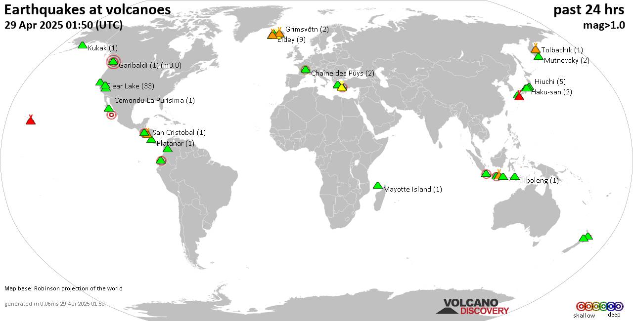
World map showing volcanoes with shallow (less than 50 km) earthquakes within 20 km radius during the past 24 hours on 29 Apr 2025 Number in brackets indicate nr of quakes.

Quakes detected near: Bardarbunga (17 quakes between mag 0.0-1.0), Chaîne des Puys (2 quakes between mag 1.1-2.3), Clear Lake (34 quakes between mag 0.2-1.9), Comondu-La Purisima (1 quake mag 2.3), Coso (4 quakes between mag 1.3-1.7), Eldey (8 quakes between mag 0.8-2.2)
Gagak (2 quakes between mag 1.8-2.2), Garibaldi (1 quake mag 3.0), Grímsvötn (2 quakes between mag 0.3-1.0), Guagua Pichincha (1 quake mag 2.6), Haku-san (2 quakes between mag 0.6-1.1), Hiuchi (5 quakes between mag 0.4-1.5), Iliboleng (1 quake mag 1.4), Katla (4 quakes between mag 0.4-1.0), Kilauea (2 quakes between mag 1.7-1.7), Kita Yatsugatake (1 quake mag 1.1), Klyuchevskoy (6 quakes between mag 1.1-2.0), Kolumbo (9 quakes between mag 1.7-2.3), Kukak (1 quake mag 1.4), Ljósufjöll (7 quakes between mag 0.5-2.3), Malang Plain (1 quake mag 2.4), Mammoth Mountain (1 quake mag 1.2), Mayotte Island (1 quake mag 1.4), Methana (1 quake mag 3.8), Mutnovsky (2 quakes between mag 0.7-1.0), Platanar (1 quake mag 1.1), Raung (1 quake mag 2.2), Reporoa (2 quakes between mag 1.1-1.6), Rinjani (1 quake mag 1.9), Sakurajima (1 quake mag 1.0), San Cristobal (1 quake mag 1.6), San

Click this link to continue reading the article on the source website.
RSS feed source: Volcano Discovery.com--Global earthquake monitor

Date and TimeMag
DepthDistanceLocationDetailsMap Apr 19, 01:15 pm (GMT +12)

4.4

33 km34 km (21 mi) to the NE South Pacific Ocean, Hawke’s Bay, 174 km west of Raoul Island, New Zealand InfoApr 11, 03:11 am (GMT +12)

4.2

303 km79 km (49 mi) to the SE New Zealand InfoMar 25, 09:35 am (GMT +13)

4.1

240 km68 km (42 mi) to the S South Pacific Ocean, 236 km southwest of Raoul Island, New Zealand InfoJan 8, 11:54 pm (GMT +12)

4.8

226 km64 km (40 mi) to the SE South Pacific Ocean, Bay of Plenty, 211 km southwest of Raoul Island, New Zealand InfoJan 2, 09:15 am (GMT +12)

4.6

211 km58 km (36 mi) to the NE South Pacific Ocean, 145 km west of Raoul Island, New Zealand InfoMay 15, 2024 03:15 pm (GMT +12)

5.3

366 km60 km (37 mi) to the SE South Pacific Ocean, 191 km southwest of Raoul Island, New Zealand InfoMar 5, 2021 08:19 pm (GMT +12)

5.3

33 km43 km (27 mi) to the S New Zealand InfoMar 5, 2021 07:28 am (GMT +12)

8.1

29 km253 km (157 mi) to the E South Pacific Ocean, 81 km southeast of Raoul Island, New Zealand 15 reportsInfoSep 4, 2019 06:46 pm (GMT +12)

5.1

33 km91 km (56 mi) to the N South Pacific Ocean, 191 km west of Raoul Island, New Zealand InfoJun 27, 2019 11:04 am (Universal Time)

5.3

10 km93 km (58 mi) to the SESouth Pacific Ocean, 173 km southwest of Raoul Island, New Zealand 1 reportInfoJun 16, 2019 10:55 am (GMT +12)

7.3

46 km191 km (118 mi) to the SE Kermadec Islands, New Zealand 10

Click this link to continue reading the article on the source website.