RSS feed source: Volcano Discovery.com--Global earthquake monitor

Date and TimeMag
DepthDistanceLocationDetailsMap May 4, 01:38 am (GMT -3)

5.5

10 km42 km (26 mi) to the NW South Atlantic Ocean, 280 km southeast of Isla Phillips Island, Region de Magallanes y Antartica Chilena, ChileI FELT IT InfoMay 4, 12:11 am (GMT -3)

4.7

10 km58 km (36 mi) to the N South Atlantic Ocean, 483 km southeast of Punta Arenas, Magallanes, Region de Magallanes y Antartica Chilena, ChileI FELT IT InfoMay 3, 10:14 pm (GMT -3)

4.7

10 km35 km (22 mi) to the NE South Atlantic Ocean, ChileI FELT IT InfoMay 3, 05:03 pm (GMT -3)

4.0

10 km97 km (60 mi) to the N South Pacific Ocean, ChileI FELT IT InfoMay 3, 12:12 pm (GMT -3)

4.2

10 km85 km (53 mi) to the N South Pacific Ocean, ChileI FELT IT InfoMay 3, 07:06 am (GMT -3)

5.1

10 km63 km (39 mi) to the N South Atlantic Ocean, ChileI FELT IT InfoMay 3, 04:48 am (GMT -3)

4.9

10 km57 km (36 mi) to the NE 264 km SSE of Ushuaia, Argentina  I FELT IT InfoMay 2, 04:14 pm (GMT -4)

5.3

10 km48 km (30 mi) to the NE 265 km SSE of Ushuaia, Argentina  I FELT IT InfoMay 2, 04:57 pm (GMT -3)

5.0

10 km38 km (24 mi) to the E 299 km SSE of Ushuaia, Argentina  I FELT IT InfoMay 2, 09:58 am (GMT -3)

7.4

10 km88 km (55 mi) to the NW South Atlantic Ocean, 236 km southeast of Isla Phillips Island, Region de Magallanes y Antartica Chilena, ChileI FELT IT35 reportsInfoMay 15,

Click this link to continue reading the article on the source website.

RSS feed source: Volcano Discovery.com--Global earthquake monitor

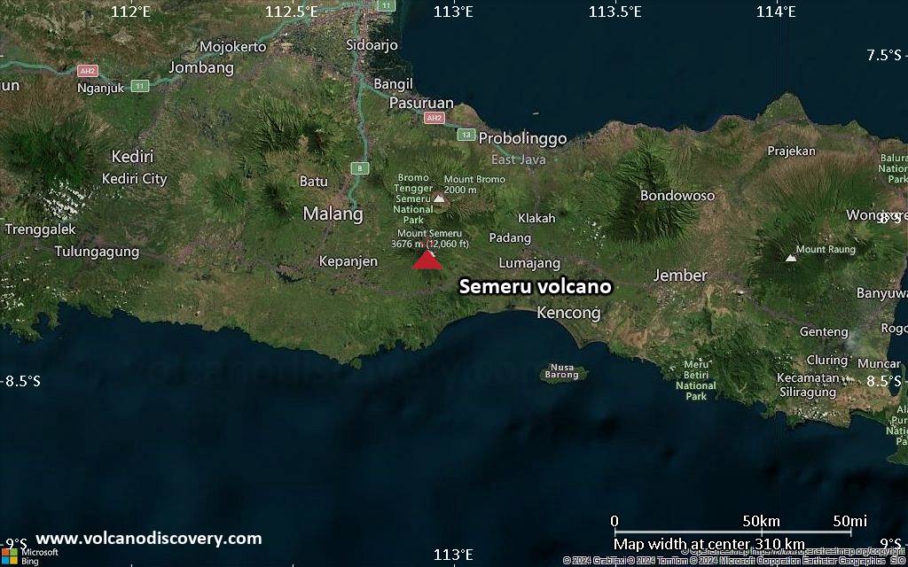
<!–div style="font-size:14px;text-align:center;border:3px solid blue;border-radius:5px;padding:3px;margin:5px;background:#eee"><a href="https://www.volcanoesandearthquakes.com/app/volcano-report.php?volcanoId=44" style="text-decoration:none" target="_blank" rel="noopener noreferrer nofollow" title="Share a volcano (activity) report, submit a photo or other interesting news!” onclick=”window.open(this.href,’Volcano Report’,’status=0,toolbar=0,location=0,directories=0,menubar=0,resizable=1,scrollbars=1,height=500,width=450′);return false”>Send Volcano Report</div–> Stratovolcano 3676 m (12,060 ft)
East Java, Indonesia, -8.11°S / 112.92°E
Current status: erupting (4 out of 5) Semeru volcano eruptions:
1818, 1829, 1830, 1832, 1836, 1838, 1842, 1844, 1845, 1848, 1849(?), 1851, 1856, 1857, 1865, 1866(?), 1887, 1887, 1888, 1889-91, 1892, 1893, 1893-94, 1895, 1896, 1897, 1899, 1899, 1900, 1901, 1903, 1904, 1905, 1907, 1908, 1909-10, 1910-11, 1911, 1912, 1913, 1941-42, 1945, 1946, 1946-47, 1950-64, 1967-ongoing
Typical eruption style
Explosive. Near constant strombolian activity, occasionally stronger explosions, lava flows and pyroclastic flows.

Click this link to continue reading the article on the source website.
RSS feed source: Volcano Discovery.com--Global earthquake monitor

Date and TimeMag
DepthDistanceLocationDetailsMap May 4, 12:11 am (GMT -3)

4.7

10 km41 km (26 mi) to the NE South Atlantic Ocean, 483 km southeast of Punta Arenas, Magallanes, Region de Magallanes y Antartica Chilena, ChileI FELT IT InfoMay 3, 10:14 pm (GMT -3)

4.7

10 km38 km (23 mi) to the E South Atlantic Ocean, ChileI FELT IT InfoMay 3, 12:12 pm (GMT -3)

4.2

10 km45 km (28 mi) to the N South Pacific Ocean, ChileI FELT IT InfoMay 3, 11:41 am (GMT -3)

4.6

10 km16 km (9.7 mi) to the NE South Atlantic Ocean, 479 km southeast of Punta Arenas, Magallanes, Region de Magallanes y Antartica Chilena, ChileI FELT IT InfoMay 3, 11:07 am (GMT -3)

4.2

10 km35 km (22 mi) to the NE South Atlantic Ocean, ChileI FELT IT InfoMay 3, 07:06 am (GMT -3)

5.1

10 km44 km (28 mi) to the NE South Atlantic Ocean, ChileI FELT IT InfoMay 2, 04:14 pm (GMT -4)

5.3

10 km44 km (28 mi) to the E 265 km SSE of Ushuaia, Argentina  I FELT IT InfoMay 2, 04:33 pm (GMT -3)

5.1

10 km50 km (31 mi) to the SE South Atlantic Ocean, 327 km southeast of Isla Phillips Island, Region de Magallanes y Antartica Chilena, ChileI FELT IT InfoMay 2, 02:59 pm (GMT -3)

6.3

10 km62 km (38 mi) to the E South Atlantic Ocean, 333 km southeast of Isla Phillips Island, Region de Magallanes y Antartica Chilena, ChileI FELT IT3 reportsInfoMay 2, 01:48 pm (GMT -3)

5.3

10 km48 km (30 mi) to the SE

Click this link to continue reading the article on the source website.

RSS feed source: Volcano Discovery.com--Global earthquake monitor

Date and TimeMag
DepthDistanceLocationDetailsMap Apr 11, 01:18 pm (Saipan)

4.9

247 km62 km (38 mi) to the W Philippine Sea, 26 km northwest of Agrihan Island, Northern Mariana Islands InfoMar 28, 11:18 pm (GMT +10)

4.3

238 km62 km (38 mi) to the W Philippine Sea, 28 km northwest of Agrihan Island, Northern Mariana Islands InfoMar 15, 03:39 pm (Saipan)

4.8

176 km31 km (19 mi) to the SW Philippine Sea, 17 km northeast of Agrihan Island, Northern Mariana Islands InfoMar 7, 04:33 pm (GMT +10)

4.7

168 km68 km (42 mi) to the NW Philippine Sea, 69 km north of Agrihan Island, Northern Mariana Islands InfoJan 31, 02:51 am (Saipan)

4.6

208 km68 km (43 mi) to the SW Philippine Sea, 21 km southwest of Agrihan Island, Northern Mariana Islands InfoJan 21, 12:10 pm (GMT +10)

4.6

179 km65 km (40 mi) to the SW Pagan Region, Northern Mariana Islands 1 reportInfoApr 5, 2024 09:03 pm (GMT +10)

6.8

222 km70 km (44 mi) to the W Philippine Sea, 52 km northwest of Agrihan Island, Northern Mariana Islands 31 reportsInfoJan 21, 2024 01:48 am (GMT +10)

6.1

184 km68 km (43 mi) to the SW Pagan Region, Northern Mariana Islands 1 reportInfoNov 19, 2023 02:01 pm (GMT +10)

5.9

585 km78 km (48 mi) to the W Philippine Sea, 37 km west of Agrihan Island, Northern Mariana Islands InfoJul 9, 2022 09:43 am (GMT +10)

5.9

10 km99 km (61 mi) to the E Pagan Region, Northern Mariana Islands 1 reportInfoFeb 12, 2019 10:34 pm (GMT +10)

5.9

142 km12 km (7.5 mi) to the W Philippine Sea, 37 km northeast of Agrihan Island, Northern Mariana Islands

Click this link to continue reading the article on the source website.