RSS feed source: Volcano Discovery.com--Global earthquake monitor

Date and TimeMag
DepthDistanceLocationDetailsMap Dec 6, 2024 01:42 pm (Port-au-Prince)

4.0

10 km92 km (57 mi) to the E Caribbean Sea, 87 km southwest of Port-de-Paix, Nord-Ouest, Haiti InfoMar 23, 2024 11:46 am (Havana)

4.0

25 km94 km (58 mi) to the W Cuba Region 6 reportsInfoJul 28, 2023 12:09 am (Havana)

4.0

0 km30 km (19 mi) to the N Cuba Region InfoFeb 16, 2023 01:50 am (GMT -5)

5.4

10 km83 km (52 mi) to the E 37 km WSW of Bombardopolis, Haiti 47 reportsInfoFeb 23, 2022 11:17 pm (Port-au-Prince)

4.1

10 km100 km (62 mi) to the E North Atlantic Ocean, 70 km west of Port-de-Paix, Nord-Ouest, Haiti InfoAug 14, 2021 08:29 am (Port-au-Prince)

7.2

10 km185 km (115 mi) to the SE Departement de Nippes, 39 km northeast of Les Cayes, Sud, Haiti 576 reportsInfoApr 29, 2020 06:22 am (Havana)

4.5

10 km47 km (29 mi) to the NE 8.6 km south of Maisí, Maisi, Guantanamo, Cuba 3 reportsInfoJan 23, 2020 10:47 pm (Havana)

4.3

10 km31 km (19 mi) to the W 51 km SSW of Baracoa, Cuba 6 reportsInfoAug 4, 2019 07:34 pm (GMT -5)

4.3

10 km38 km (24 mi) to the SE 76 km S of Maisí, Cuba InfoJun 20, 2017 02:01 pm (GMT -5)

4.4

13 km63 km (39 mi) to the SE 75 km N of Jérémie, Haiti InfoJan 30, 2017 10:47 pm (GMT -5)

4.4

10 km97 km (60 mi) to the SE 63 km SW of Bombardopolis, Haiti InfoSep 30, 2016 06:06 pm (GMT -5)

5.0

10 km19 km (12 mi) to the E Caribbean Sea, 51 km south of Maisi, Provincia de Guantanamo, Cuba InfoMar 28, 2016 08:57 am (GMT

Click this link to continue reading the article on the source website.

RSS feed source: Volcano Discovery.com--Global earthquake monitor

Date and TimeMag
DepthDistanceLocationDetailsMap Apr 11, 02:46 pm (GMT +9)

4.5

49 km75 km (47 mi) to the SE 108 km S of Yudomari, Japan InfoApr 11, 02:41 pm (GMT +9)

4.6

38 km81 km (50 mi) to the SE 116 km S of Yudomari, Japan InfoApr 11, 02:15 pm (GMT +9)

4.4

48 km88 km (55 mi) to the SE 116 km S of Koshima, Japan InfoApr 11, 02:06 pm (GMT +9)

5.0

28 km76 km (47 mi) to the SE 114 km NE of Tatsugō, Japan 2 reportsInfoMar 17, 06:22 pm (GMT +9)

4.7

45 km74 km (46 mi) to the SE 96 km S of Koshima, Japan InfoSep 14, 2024 08:03 am (GMT +9)

5.7

30 km102 km (63 mi) to the E Philippine Sea, 99 km southeast of Kuchinoerabu-jima Island, Kagoshima, Japan 1 reportInfoAug 8, 2024 04:42 pm (GMT +9)

7.1

24 km278 km (173 mi) to the NE Philippine Sea, 19 km southeast of Miyazaki, Miyazaki, Japan 38 reportsInfoDec 9, 2021 11:05 am (GMT +9)

6.0

7 km57 km (35 mi) to the SW East China Sea, 117 km north of Naze, Kagoshima, Japan InfoMay 15, 2019 02:24 pm (GMT +9)

5.6

42 km73 km (45 mi) to the E Philippine Sea, 74 km south of Miyanoura, Kagoshima-ken, Japan InfoJul 10, 2012 04:25 am (GMT +9)

5.6

39 km40 km (25 mi) to the SE East China Sea, Kagoshima-ken, 46 km southeast of Suwanose-jima Island, Japan InfoOct 30, 2009 04:03 pm (GMT +9)

6.8

34 km53 km (33 mi) to the S East China Sea, Kagoshima-ken, 46 km south of Suwanose-jima Island, Japan InfoDec 11, 2006 12:28 am (GMT +9)

5.7

35 km62 km (39 mi) to the

Click this link to continue reading the article on the source website.
RSS feed source: Volcano Discovery.com--Global earthquake monitor

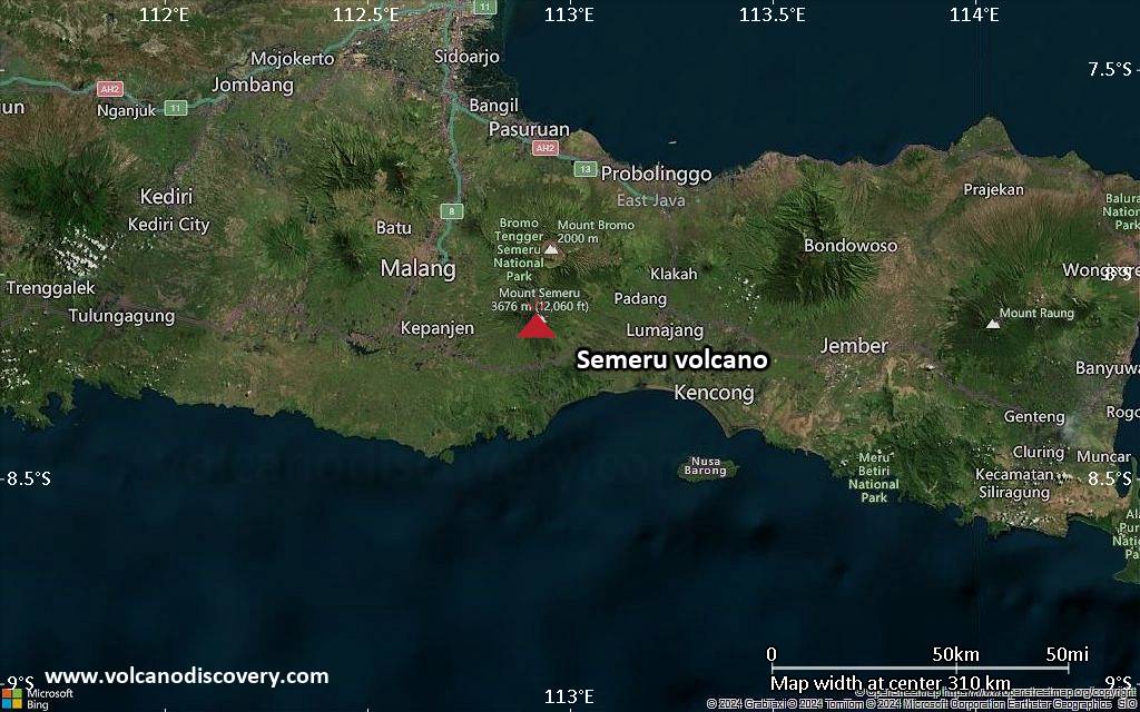
<!–div style="font-size:14px;text-align:center;border:3px solid blue;border-radius:5px;padding:3px;margin:5px;background:#eee"><a href="https://www.volcanoesandearthquakes.com/app/volcano-report.php?volcanoId=44" style="text-decoration:none" target="_blank" rel="noopener noreferrer nofollow" title="Share a volcano (activity) report, submit a photo or other interesting news!” onclick=”window.open(this.href,’Volcano Report’,’status=0,toolbar=0,location=0,directories=0,menubar=0,resizable=1,scrollbars=1,height=500,width=450′);return false”>Send Volcano Report</div–> Stratovolcano 3676 m (12,060 ft)
East Java, Indonesia, -8.11°S / 112.92°E
Current status: erupting (4 out of 5) Semeru volcano eruptions:
1818, 1829, 1830, 1832, 1836, 1838, 1842, 1844, 1845, 1848, 1849(?), 1851, 1856, 1857, 1865, 1866(?), 1887, 1887, 1888, 1889-91, 1892, 1893, 1893-94, 1895, 1896, 1897, 1899, 1899, 1900, 1901, 1903, 1904, 1905, 1907, 1908, 1909-10, 1910-11, 1911, 1912, 1913, 1941-42, 1945, 1946, 1946-47, 1950-64, 1967-ongoing
Typical eruption style
Explosive. Near constant strombolian activity, occasionally stronger explosions, lava flows and pyroclastic flows.

Click this link to continue reading the article on the source website.

RSS feed source: Volcano Discovery.com--Global earthquake monitor

Date and TimeMag
DepthDistanceLocationDetailsMap May 8, 08:22 pm (GMT -6)

4.0

16 km77 km (48 mi) to the S North Pacific Ocean, 117 km southeast of Salina Cruz, Estado de Oaxaca, MexicoI FELT IT InfoMay 7, 02:18 am (GMT -6)

4.0

16 km55 km (34 mi) to the S North Pacific Ocean, 102 km southwest of Tonala, Estado de Chiapas, MexicoI FELT IT InfoMay 6, 09:37 pm (GMT -6)

4.1

16 km64 km (40 mi) to the SW North Pacific Ocean, 88 km southeast of Salina Cruz, Estado de Oaxaca, MexicoI FELT IT InfoMay 6, 04:28 pm (GMT -6)

4.0

6.5 km79 km (49 mi) to the SW North Pacific Ocean, 89 km south of Salina Cruz, Estado de Oaxaca, MexicoI FELT IT InfoMay 6, 07:51 am (GMT -6)

4.0

67 km57 km (36 mi) to the SE North Pacific Ocean, 50 km southwest of Tonala, Estado de Chiapas, MexicoI FELT IT InfoAug 5, 2024 01:03 pm (Mexico City)

5.5

127 km97 km (60 mi) to the N Estado de Oaxaca, 37 km west of Cintalapa de Figueroa, Estado de Chiapas, Mexico 30 reportsInfoAug 9, 2023 03:33 am (Mexico City)

5.8

104 km68 km (43 mi) to the E 2.9 km southwest of Tonala, Estado de Chiapas, Mexico 140 reportsInfoMar 1, 2023 10:40 pm (Mexico City)

5.8

98 km29 km (18 mi) to the NW Mexico: 47 Km Al SURESTE De UNION HIDALGO, OAX 169 reportsInfoJun 23, 2020 03:29 pm (Universal Time)

7.1

10 km150 km (93 mi) to the W 62 km west of Salina Cruz, Estado de Oaxaca, Mexico 469 reportsInfoJan

Click this link to continue reading the article on the source website.