RSS feed source: Volcano Discovery.com--Global earthquake monitor

Date and TimeMag
DepthDistanceLocationDetailsMap Mar 22, 01:27 pm (GMT +8)

4.7

18 km90 km (56 mi) to the W 73 km E of Kinablangan, Philippines InfoMar 13, 03:40 am (GMT +8)

4.2

10 km88 km (55 mi) to the NW Philippine Sea, 119 km east of Bislig, Surigao del Sur, Caraga, Philippines InfoMar 13, 12:09 am (GMT +9)

5.7

10 km79 km (49 mi) to the NW 130 km E of Barcelona, Philippines 4 reportsInfoJan 1, 06:32 am (GMT +8)

4.6

10 km87 km (54 mi) to the W 86 km ENE of Kinablangan, Philippines InfoDec 27, 2024 09:57 am (GMT +8)

4.7

18 km100 km (62 mi) to the W76 km ENE of Kinablangan, Philippines InfoAug 19, 2024 11:32 pm (GMT +8)

4.9

10 km98 km (61 mi) to the W 76 km ENE of Kinablangan, Philippines InfoApr 26, 2024 12:20 am (GMT +8)

5.0

18 km73 km (45 mi) to the W 090 km N 82° E of Baganga (Davao Oriental) 1 reportInfoJan 29, 2024 03:37 pm (GMT +8)

5.1

10 km97 km (60 mi) to the NW Philippine Islands Region 1 reportInfoDec 2, 2023 10:37 pm (Manila)

7.6

40 km194 km (120 mi) to the NW Philippine Sea, 36 km north of Bislig, Surigao del Sur, Caraga, Philippines 565 reportsInfoAug 11, 2021 05:46 pm (GMT +0)

7.0

63 km205 km (128 mi) to the SW Philippine Sea, 74 km southeast of Mati, Davao Oriental, Davao, Philippines 617 reportsInfoMay 6, 2020 11:53 am (GMT +9)

5.0

11 km92 km (57 mi) to the SW Philippine Sea, 121 km southeast of Daquit Island, Philippines InfoJun 1, 2014 04:54 am (GMT +9)

5.3

333 km50 km (31 mi) to the E Philippine Sea,

Click this link to continue reading the article on the source website.

RSS feed source: Volcano Discovery.com--Global earthquake monitor

Background:

Volcán Popocatépetl, whose name is the Aztec word for smoking mountain, towers to 5426 m 70 km SE of Mexico City to form North America’s 2nd-highest volcano.  The glacier-clad stratovolcano contains a steep-walled, 250-450 m deep crater.  The generally symmetrical volcano is modified by the sharp-peaked Ventorrillo on the NW, a remnant of an earlier volcano. 
At least three previous major cones were destroyed by gravitational failure during the Pleistocene, producing massive debris-avalanche deposits covering broad areas south of the volcano.  The modern volcano was constructed to the south of the late-Pleistocene to Holocene El Fraile cone.  Three major plinian eruptions, the most recent of which took place about 800 AD, have occurred from Popocatépetl since the mid Holocene, accompanied by pyroclastic flows and voluminous lahars that swept basins below the volcano.  Frequent historical eruptions, first recorded in Aztec codices, have occurred since precolumbian

Click this link to continue reading the article on the source website.

RSS feed source: Volcano Discovery.com--Global earthquake monitor

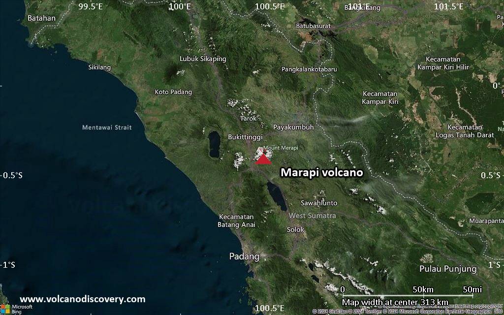
<!–div style="font-size:14px;text-align:center;border:3px solid blue;border-radius:5px;padding:3px;margin:5px;background:#eee"><a href="https://www.volcanoesandearthquakes.com/app/volcano-report.php?volcanoId=62" style="text-decoration:none" target="_blank" rel="noopener noreferrer nofollow" title="Share a volcano (activity) report, submit a photo or other interesting news!” onclick=”window.open(this.href,’Volcano Report’,’status=0,toolbar=0,location=0,directories=0,menubar=0,resizable=1,scrollbars=1,height=500,width=450′);return false”>Send Volcano Report</div–> Stratovolcano 2891 m (9,485 ft)
Western Sumatra, Indonesia, -0.39°S / 100.46°E
Current status: erupting (4 out of 5) Marapi volcano eruptions:
2011-ongoing, 2004 (Aug), 2001, 2000, 1999, 1987-94, 1984, 1984, 1983, 1982, 1980, 1975-79, 1973, 1970-71, 1968(?), 1967, 1966, 1958, 1958, 1954-57, 1950-52, 1949, 1949, 1943, 1932, 1930, 1929, 1927, 1925, 1919, 1918, 1918, 1917, 1916, 1915, 1913, 1911, 1910, 1907-08, 1905, 1904, 1889, 1888, 1886, 1885, 1883, 1878(?), 1883, 1876-77, 1876, 1871, 1871, 1863, 1861, 1855-56, 1854, 1845, 1833-34, 1822, 1807, 1770
Typical eruption style
Small to moderate sized explosions

Click this link to continue reading the article on the source website.
RSS feed source: Volcano Discovery.com--Global earthquake monitor

Familiarity with imaging analysis and/or computer vision is a plus.

Applicants will need to provide a letter of interest (1-2pg), a complete CV, at least two exemplar publications, and at least three academic / research references.

Applications and associated information will be accepted until the position is filled.

The target start date of this position is 15 May 2025, but sooner may be possible.

FLSA STATUS
United States of America (Exempt)

WPI is an Equal Opportunity Employer. All qualified candidates will receive consideration for employment without regard to race, color, age, religion, sex, sexual orientation, gender identity, national origin, veteran status, or disability. It seeks individuals from all backgrounds and experiences who will contribute to a culture of creativity, collaboration, inclusion, problem solving, innovation, high performance, and change making. It is committed to maintaining a campus environment free of harassment and discrimination.

To apply, visit: https://wpi.wd5.myworkdayjobs.com/en-US/WPI_External_Career_Site/job/Worcester/Post-Doctoral-Fellow_R0003137

About WPI
WPI is a vibrant, active,

Click this link to continue reading the article on the source website.