RSS feed source: Volcano Discovery.com--Global earthquake monitor

Wednesday, Dec 3, 2025 09:50 | 42 mins ago | By: EarthquakeMonitor

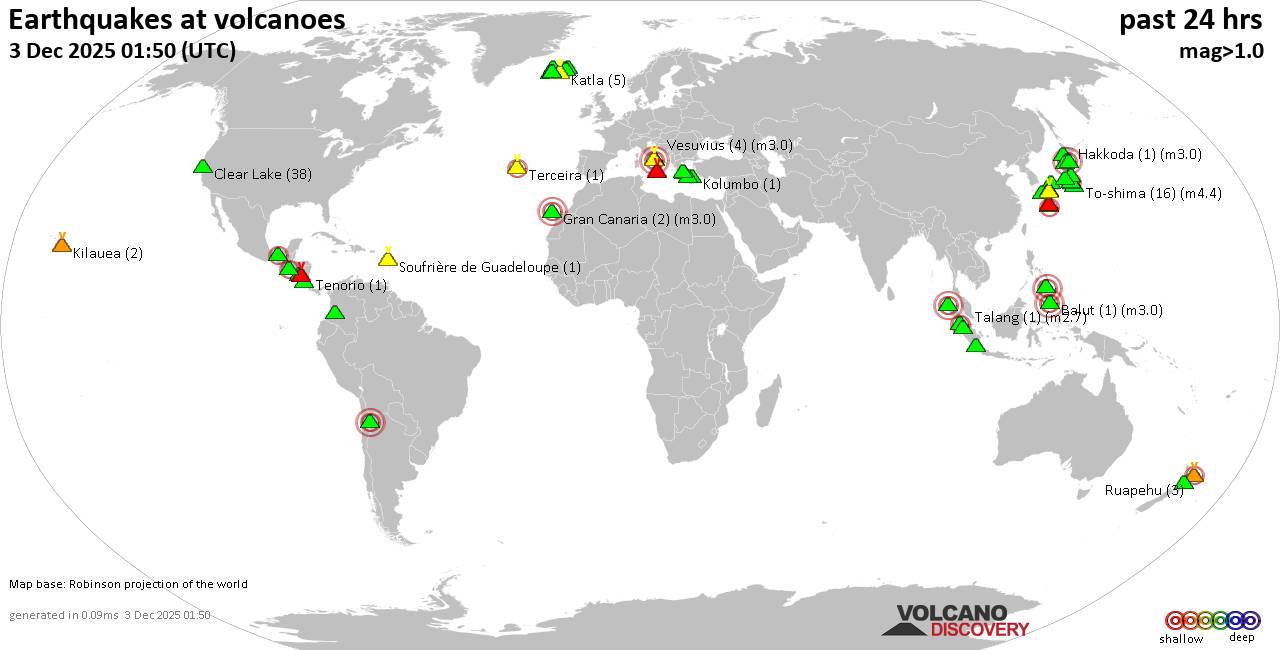
World map showing volcanoes with shallow (less than 50 km) earthquakes within 20 km radius during the past 24 hours on 3 Dec 2025 Number in brackets indicate nr of quakes.

Quakes detected near: Akuseki-jima (3 quakes between mag 1.4-2.2), Apaneca Range (1 quake mag 2.2), Aso (36 quakes between mag 0.1-2.2), Balut (1 quake mag 3.0), Campi Flegrei (Phlegrean Fields) (4 quakes between mag 0.1-3.0), Clear Lake (43 quakes between mag 0.2-1.8)
El Chichón (5 quakes between mag 2.1-2.7), Eldey (36 quakes between mag 0.6-2.9), Etna (1 quake mag 1.5), Fagradalsfjall (1 quake mag 1.0), Geureudong (1 quake mag 3.3), Gran Canaria (2 quakes between mag 1.2-3.0), Hibok-Hibok (1 quake mag 3.0), Hulubelu (1 quake mag 1.8), Kilauea (2 quakes between mag 1.0-1.4), Ljósufjöll (3 quakes between mag 0.7-1.3), Loihi (2 quakes between mag 1.7-1.8), Maunaloa (2 quakes between mag 1.8-1.8), Megata (1 quake mag 3.0), Methana (4 quakes between mag 1.2-1.7), Milos (3 quakes between mag 1.6-3.5), Mt Fuji (5 quakes between mag 0.4-2.5), Nigorigawa (1 quake mag 1.4), Piton de la Fournaise (15 quakes between mag 0.1-1.9), Pular (1 quake mag 3.0), Ruapehu (2 quakes between mag 1.1-1.3), Sanbe (1 quake mag 1.1), Sousaki (1 quake mag 1.9), Suwanose-jima (1 quake mag 1.8), Takahara (3 quakes between mag

Click this link to continue reading the article on the source website.

RSS feed source: Volcano Discovery.com--Global earthquake monitor

Date and TimeMag
DepthDistanceLocationDetailsMap May 27, 07:55 am (GMT +7)

5.4

14 km97 km (60 mi) to the SE Indian Ocean, 293 km south of Yogyakarta, Indonesia 5 reportsInfoJan 14, 11:28 am (GMT +7)

4.3

10 km52 km (32 mi) to the W241 km S of Cilacap, Indonesia 1 reportInfoDec 2, 2024 11:06 pm (GMT +7)

4.3

5 km94 km (58 mi) to the NE Indian Ocean, 159 km south of Yogyakarta, Indonesia InfoNov 1, 2024 03:33 pm (GMT +7)

4.5

8 km94 km (58 mi) to the NW Indian Ocean, 215 km southwest of Yogyakarta, Indonesia 1 reportInfoSep 13, 2024 02:12 pm (GMT +7)

4.3

47 km94 km (58 mi) to the NE148 km S of Pundong, Indonesia 2 reportsInfoMar 28, 2024 03:01 pm (GMT +7)

5.0

10 km79 km (49 mi) to the NE Indian Ocean, 168 km south of Yogyakarta, Indonesia 4 reportsInfoMar 17, 2023 07:05 pm (GMT +7)

5.0

50 km85 km (53 mi) to the N South of Java, Indonesia 14 reportsInfoDec 25, 2022 03:57 am (GMT +7)

5.3

10 km65 km (40 mi) to the NW Indian Ocean, 225 km southwest of Yogyakarta, Indonesia InfoSep 8, 2022 02:01 pm (GMT +7)

4.9

10 km94 km (58 mi) to the S Indian Ocean, 324 km south of Yogyakarta, Indonesia 1 reportInfoDec 13, 2020 08:39 am (Universal Time)

5.1

10 km15 km (9.3 mi) to the Enear Magnitude 5.1, Near of Semarang InfoNov 1, 2020 04:38 am (GMT +7)

4.7

12 km96 km (60 mi) to the NW 409 km southeast of Jakarta, Indonesia InfoOct 19, 2020 11:09 pm (GMT +7)

4.8

28 km99 km (61 mi) to the W 452 km southeast of Jakarta, Indonesia 1 reportInfoAug 10,

Click this link to continue reading the article on the source website.

RSS feed source: Volcano Discovery.com--Global earthquake monitor

Date and TimeMag
DepthDistanceLocationDetailsMap Sep 28, 02:51 am (GMT -7)

4.0

5.5 km39 km (24 mi) to the NW Off Coast of Jalisco, Mexico InfoSep 25, 04:11 am (GMT -7)

4.1

10 km49 km (31 mi) to the S Off Coast of Jalisco, Mexico InfoSep 25, 03:52 am (GMT -7)

4.4

10 km53 km (33 mi) to the S North Pacific Ocean, 207 km southwest of Manzanillo, Estado de Colima, Mexico InfoSep 25, 03:21 am (GMT -7)

5.1

10 km39 km (24 mi) to the SE North Pacific Ocean, 186 km southwest of Manzanillo, Estado de Colima, Mexico InfoSep 25, 03:16 am (GMT -7)

5.7

10 km51 km (31 mi) to the SE North Pacific Ocean, 200 km southwest of Manzanillo, Estado de Colima, Mexico 2 reportsInfoSep 22, 07:24 am (GMT -7)

5.4

10 km52 km (33 mi) to the NW 159 km SW of José María Morelos, Mexico 1 reportInfoJan 31, 07:20 am (GMT -7)

4.5

10.3 km49 km (30 mi) to the NW North Pacific Ocean, 175 km southwest of Tomatlan, Estado de Jalisco, Mexico InfoOct 16, 2024 12:41 pm (GMT -7)

5.8

10 km83 km (51 mi) to the NW North Pacific Ocean, 257 km west of Manzanillo, Estado de Colima, Mexico 1 reportInfoOct 15, 2024 04:49 pm (GMT -7)

5.2

10 km68 km (42 mi) to the NW North Pacific Ocean, 243 km west of Manzanillo, Estado de Colima, Mexico InfoApr 21, 2024 12:05 pm (GMT -7)

5.5

16 km18 km (11 mi) to the SE North Pacific Ocean, 187 km southwest of Manzanillo, Estado de Colima, Mexico 2 reportsInfoJul 18, 2023 03:13 am (GMT -7)

5.6

10 km79 km (49 mi) to the

Click this link to continue reading the article on the source website.