RSS feed source: USGS Earthquake Hazards Program
Time2025-04-18 07:24:13 UTC2025-04-18 07:24:13 UTC at epicenterLocation6.212°S 151.639°EDepth10.00 km (6.21 mi)
Click this link to continue reading the article on the source website.
RSS feed source: USGS Earthquake Hazards Program
Time2025-04-18 07:24:13 UTC2025-04-18 07:24:13 UTC at epicenterLocation6.212°S 151.639°EDepth10.00 km (6.21 mi)
Click this link to continue reading the article on the source website.
RSS feed source: USGS Earthquake Hazards Program
Date and TimeMag
DepthDistanceLocationDetailsMap Apr 15, 12:54 am (Merida)
4.0
152 km117 km (73 mi) to the SE 11 km southeast of Cintalapa de Figueroa, Chiapas, Mexico I FELT IT InfoApr 11, 08:19 am (Merida)
4.4
173 km201 km (125 mi) to the SE 48 km southeast of Tuxtla, Chiapas, Mexico I FELT IT InfoApr 8, 08:06 pm (Merida)
4.2
104 km180 km (112 mi) to the SE 26 km southeast of Tonala, Chiapas, Mexico InfoMar 29, 11:16 am (Merida)
4.0
163 km184 km (114 mi) to the SE 31 km southeast of Tuxtla, Chiapas, Mexico InfoMar 21, 09:50 am (Merida)
4.0
101 km213 km (132 mi) to the SE Chiapas, Mexico InfoFeb 24, 06:57 pm (Universal Time)
4.3
145 km72 km (45 mi) to the SE Oaxaca, 34 km northwest of Cintalapa de Figueroa, Chiapas, Mexico InfoFeb 15, 10:00 am (Merida)
4.4
147 km115 km (72 mi) to the SE 11 km south of Cintalapa de Figueroa, Chiapas, Mexico InfoOct 26, 2024 02:50 pm (Merida)
4.3
167 km245 km (152 mi) to the SE Mexico: 37 km al NORTE de MAPASTEPEC, CHIS InfoSep 15, 2024 07:23 pm (Merida)
4.3
157 km167 km (104 mi) to the SE Mexico: 9 km al NOROESTE de VILLAFLORES, CHIS InfoAug 5, 2024 01:03 pm (Mexico City)
5.5
127 km75 km (46 mi) to the SE Oaxaca, 37 km west of Cintalapa de Figueroa, Chiapas, Mexico 30 reportsInfoAug 9, 2023 03:33 am (Mexico City)
5.8
104 km153 km (95 mi) to the SE 19 Km SSW of Agrónomos Mexicanos, Mexico 140 reportsInfoJun 19, 2021 01:57 pm (Mexico City)
5.4
227 km257 km (160 mi) to the SE 61 km southwest of Comitan, Chiapas, Mexico InfoAug 12, 2019
Click this link to continue reading the article on the source website.
RSS feed source: USGS Earthquake Hazards Program
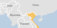
On 12/04/2025, a flood started in Vietnam, lasting until 15/04/2025 (last update). The flood caused 2 deaths and 0 displaced .
Click this link to continue reading the article on the source website.
RSS feed source: USGS Earthquake Hazards Program
Date and TimeMag
DepthDistanceLocationDetailsMap Apr 18, 10:01 am (GMT +10)
4.8
10 km21 km (13 mi) to the W Solomon Sea, 152 km south of Lolobau Island, Papua New Guinea I FELT IT InfoApr 18, 02:01 am (GMT +10)
4.7
35 km32 km (20 mi) to the SE Solomon Sea, 179 km southeast of Lolobau Island, Papua New Guinea I FELT IT InfoApr 14, 06:17 pm (GMT +10)
4.5
10 km64 km (40 mi) to the NE Solomon Sea, 155 km southeast of Lolobau Island, Papua New Guinea I FELT IT InfoApr 14, 02:04 am (GMT +10)
4.8
10 km39 km (24 mi) to the E Solomon Sea, 175 km southeast of Lolobau Island, Papua New Guinea I FELT IT InfoApr 13, 11:59 pm (GMT +10)
5.0
10 km47 km (29 mi) to the E Solomon Sea, 171 km southeast of Lolobau Island, Papua New Guinea I FELT IT InfoApr 11, 01:38 pm (GMT +10)
5.2
10 km12 km (7.3 mi) to the NE Solomon Sea, 145 km southeast of Lolobau Island, Papua New Guinea I FELT IT InfoApr 10, 06:20 pm (GMT +10)
5.2
10 km37 km (23 mi) to the W 153 km ESE of Kimbe, Papua New Guinea InfoApr 10, 12:43 pm (GMT +10)
5.4
10 km25 km (16 mi) to the W Solomon Sea, 152 km south of Lolobau Island, Papua New Guinea InfoApr 7, 11:08 pm (GMT +10)
5.1
10 km18 km (11 mi) to the W Solomon Sea, 154 km south of Lolobau Island, Papua New Guinea InfoApr 6, 08:02 pm (GMT +10)
5.2
10 km15 km (9.2 mi) to the E Solomon Sea, 160 km southeast
Click this link to continue reading the article on the source website.