RSS feed source: Volcano Discovery.com--Global earthquake monitor

Date and TimeMag
DepthDistanceLocationDetailsMap Apr 4, 03:31 am (GMT -5)

4.8

10 km87 km (54 mi) to the NE North Pacific Ocean, Panama InfoNov 19, 2024 09:17 pm (GMT -6)

4.0

10 km9.7 km (6 mi) to the WOff the Coast of Central America InfoNov 15, 2024 07:38 am (GMT -5)

4.4

0 km50 km (31 mi) to the SE Océano Pacífico InfoAug 29, 2024 03:05 pm (GMT -6)

4.1

10 km14 km (8.6 mi) to the SW south of Panama InfoJun 3, 2024 06:34 pm (GMT -6)

4.2

10 km74 km (46 mi) to the NE South of Panama InfoOct 5, 2023 10:28 pm (GMT -5)

5.4

10 km76 km (47 mi) to the NE North Pacific Ocean, Panama 4 reportsInfoSep 19, 2021 10:33 am (GMT -5)

4.9

10 km53 km (33 mi) to the NE South of Panama 1 reportInfoApr 17, 2019 04:55 am (GMT -5)

4.8

10 km105 km (65 mi) to the NE South of Panama InfoMay 18, 2018 08:56 am (GMT -5)

5.1

10 km85 km (53 mi) to the NE South of Panama InfoMay 18, 2018 07:43 am (GMT -5)

5.4

10 km91 km (56 mi) to the NE South of Panama InfoJan 11, 2016 09:13 am (GMT -6)

4.8

10 km47 km (29 mi) to the NE South of Panama InfoJul 23, 2011 06:53 am (GMT -6)

5.0

10 km61 km (38 mi) to the NE South of Panama InfoApr 10, 2011 03:33 pm (GMT -6)

5.0

10 km77 km (48 mi) to the NE South of Panama InfoApr 21, 2010 02:15 am (GMT -6)

4.9

10 km105 km (65 mi) to the N North Pacific Ocean, 469 km south of Santiago, Provincia de Veraguas, Panama InfoNov 15, 2009 11:36 am (GMT -6)

5.2

25 km15 km (9 mi) to the

Click this link to continue reading the article on the source website.

RSS feed source: Volcano Discovery.com--Global earthquake monitor

Fri, 25 Apr 2025, 07:34 | BY: EARTHQUAKEMONITOR

The European-Mediterranean Seismological Centre (EMSC) reported a magnitude 4.6 quake in Turkey near Simav, Kütahya, only 13 minutes ago. The earthquake hit in the morning on Friday, April 25th, 2025, at 10:20 am local time at a very shallow depth of 8. km. The exact magnitude, epicenter, and depth of the quake might be revised within the next few hours or minutes as seismologists review data and refine their calculations, or as other agencies issue their report.
Our monitoring service identified a second report from Turkey’s Disaster and Emergency Management Authority (AFAD) which listed the quake at magnitude 4.6 as well. Other agencies reporting the same quake include the Kandilli Oservatory and Earthquake Research Institute in Istanbul (KOERI-RETMC) at magnitude 4.8, the German Research Centre for Geosciences (GFZ) at magnitude 4.5, the National Observatory of Athens (NOA) at magnitude 4.4, the citizen-seismograph network of RaspberryShake at magnitude 4.6, and The Aristotle University of Thessaloniki Geophysical Lab. (AUTH) at magnitude 4.4.
Based on the preliminary seismic data, the quake should not have caused any significant damage, but was probably felt by many people as light vibration in the area of the epicenter.
Weak shaking might have been felt in Simav (pop. 34,900) located 23 km from the epicenter, Emet (pop. 23,800) 32 km away, Demirci (pop. 21,400)

Click this link to continue reading the article on the source website.

RSS feed source: Volcano Discovery.com--Global earthquake monitor

Date and TimeMag
DepthDistanceLocationDetailsMap Apr 25, 07:23 am (Istanbul)

4.5

10 km2.8 km (1.8 mi) to the NW 25 km north of Simav, Kütahya, TurkeyI FELT IT6 reportsInfoApr 21, 08:24 pm (Istanbul)

4.0

7.1 km4.5 km (2.8 mi) to the SW 19 km north of Simav, Kütahya, TurkeyI FELT IT1 reportInfoApr 16, 02:19 am (Istanbul)

4.1

10 km91 km (57 mi) to the E 13 km south of Kutahya, Kütahya, Turkey InfoJan 27, 01:43 pm (Istanbul)

4.0

10.4 km102 km (64 mi) to the N 9.3 km west of Bursa, Bursa, Turkey 25 reportsInfoAug 3, 2024 05:05 am (Istanbul)

4.0

4.7 km63 km (39 mi) to the N Turkey: Büyükorhan (Bursa) 5 reportsInfoOct 11, 2023 12:38 pm (Istanbul)

5?

10 km46 km (29 mi) to the N 56 km south of Bursa, Bursa, Turkey (unconfirmed) 12 reportsInfoFeb 24, 2020 05:43 am (Istanbul)

4.8

10 km96 km (60 mi) to the W 12 km northeast of Akhisar, Manisa, Turkey 338 reportsInfoFeb 4, 2020 08:55 pm (Istanbul)

4.8

10 km90 km (56 mi) to the W 17 km northeast of Akhisar, Manisa, Turkey 667 reportsInfoJan 28, 2020 02:26 pm (Istanbul)

4.9

10 km98 km (61 mi) to the W 105 km northeast of İzmir, Turkey 571 reportsInfoJan 22, 2020 10:22 pm (Istanbul)

5.5

10 km102 km (63 mi) to the W Turkey 1189 reportsInfoApr 21, 2017 04:09 pm (Istanbul)

5.0

10 km61 km (38 mi) to the S Kütahya, 24 km northwest of Usak, Usak, Turkey 14 reportsInfoMay 3, 2012 06:20 pm (Istanbul)

5.2

3.1 km16 km (9.9 mi) to the SE 14 km northeast of Simav, Kütahya, Turkey InfoMay 28, 2011 08:47 am (Istanbul)

4.8

9.2 km20 km (12 mi) to the S

Click this link to continue reading the article on the source website.
RSS feed source: Volcano Discovery.com--Global earthquake monitor

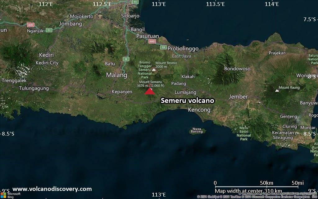
<!–div style="font-size:14px;text-align:center;border:3px solid blue;border-radius:5px;padding:3px;margin:5px;background:#eee"><a href="https://www.volcanoesandearthquakes.com/app/volcano-report.php?volcanoId=44" style="text-decoration:none" target="_blank" rel="noopener noreferrer nofollow" title="Share a volcano (activity) report, submit a photo or other interesting news!” onclick=”window.open(this.href,’Volcano Report’,’status=0,toolbar=0,location=0,directories=0,menubar=0,resizable=1,scrollbars=1,height=500,width=450′);return false”>Send Volcano Report</div–> Stratovolcano 3676 m (12,060 ft)
East Java, Indonesia, -8.11°S / 112.92°E
Current status: erupting (4 out of 5) Semeru volcano eruptions:
1818, 1829, 1830, 1832, 1836, 1838, 1842, 1844, 1845, 1848, 1849(?), 1851, 1856, 1857, 1865, 1866(?), 1887, 1887, 1888, 1889-91, 1892, 1893, 1893-94, 1895, 1896, 1897, 1899, 1899, 1900, 1901, 1903, 1904, 1905, 1907, 1908, 1909-10, 1910-11, 1911, 1912, 1913, 1941-42, 1945, 1946, 1946-47, 1950-64, 1967-ongoing
Typical eruption style
Explosive. Near constant strombolian activity, occasionally stronger explosions, lava flows and pyroclastic flows.

Click this link to continue reading the article on the source website.