RSS feed source: USGS Earthquake Hazards Program
Time2025-04-30 08:43:29 UTC2025-04-30 08:43:29 UTC at epicenterLocation7.453°S 128.746°EDepth127.88 km (79.46 mi)
Click this link to continue reading the article on the source website.
RSS feed source: USGS Earthquake Hazards Program
Time2025-04-30 08:43:29 UTC2025-04-30 08:43:29 UTC at epicenterLocation7.453°S 128.746°EDepth127.88 km (79.46 mi)
Click this link to continue reading the article on the source website.
RSS feed source: USGS Earthquake Hazards Program
Date and TimeMag
DepthDistanceLocationDetailsMap Apr 29, 10:14 pm (GMT -7)
4.7
10 km15 km (9.4 mi) to the E Northern East Pacific Rise I FELT IT InfoMar 28, 03:35 am (GMT -7)
4.8
10 km87 km (54 mi) to the E Northern East Pacific Rise InfoJan 30, 04:24 pm (GMT -7)
4.6
10 km22 km (13 mi) to the SE Northern East Pacific Rise 1 reportInfoApr 12, 2024 12:27 pm (GMT -7)
4.6
10 km17 km (10.4 mi) to the SE Northern East Pacific Rise InfoDec 1, 2023 02:07 pm (GMT -7)
4.2
10 km32 km (20 mi) to the NENorthern East Pacific Rise InfoJul 13, 2023 12:00 am (GMT -7)
4.8
10 km31 km (19 mi) to the E Northern East Pacific Rise InfoJul 12, 2023 08:29 pm (GMT -7)
5.3
10 km49 km (31 mi) to the E Northern East Pacific Rise InfoOct 11, 2021 01:23 pm (GMT -7)
4.7
10 km67 km (42 mi) to the E Northern East Pacific Rise InfoDec 9, 2018 10:03 pm (GMT -7)
4.7
10 km82 km (51 mi) to the E Northern East Pacific Rise InfoApr 28, 2016 06:33 pm (GMT -7)
6.6
10 km80 km (50 mi) to the E Northern East Pacific Rise 2 reportsInfoApr 16, 2016 08:20 am (GMT -7)
4.9
10 km29 km (18 mi) to the NE Northern East Pacific Rise InfoMar 26, 2012 11:12 am (GMT -7)
6.0
10 km46 km (29 mi) to the E Northern East Pacific Rise InfoMar 26, 2012 10:58 am (GMT -7)
5.0
10 km26 km (16 mi) to the E Northern East Pacific Rise InfoMar 26, 2012 10:56 am (GMT -7)
5.2
10 km49 km (30 mi) to the SE Northern East Pacific Rise InfoMar 26, 2012 10:48 am (GMT -7)
5.5
10 km38 km (23 mi)
Click this link to continue reading the article on the source website.
RSS feed source: USGS Earthquake Hazards Program
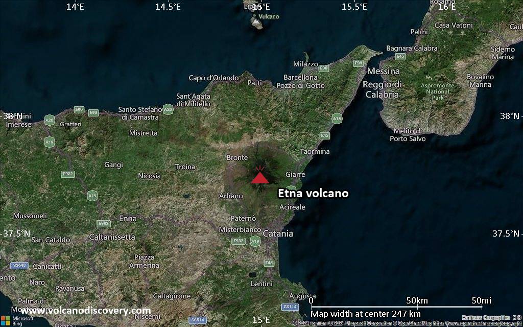
<!–div style="font-size:14px;text-align:center;border:3px solid blue;border-radius:5px;padding:3px;margin:5px;background:#eee"><a href="https://www.volcanoesandearthquakes.com/app/volcano-report.php?volcanoId=16" style="text-decoration:none" target="_blank" rel="noopener noreferrer nofollow" title="Share a volcano (activity) report, submit a photo or other interesting news!” onclick=”window.open(this.href,’Volcano Report’,’status=0,toolbar=0,location=0,directories=0,menubar=0,resizable=1,scrollbars=1,height=500,width=450′);return false”>Send Volcano Report</div–> Complex stratovolcano Currently 3,369 m / 11,053 ft (changing due to eruptive activity and collapse of its crater rims)
Sicily, Italy, 37.75°N / 14.99°E
Current status: erupting (4 out of 5) Etna volcano eruptions:
Near continuously active; some major historic eruptions include 122 BC (large Plinian outbursts that created the small caldera of the “Cratere del Piano”), 1669 AD (devastating flank eruption that destroyed 15 villages and part of Catania), 1787 (Subplinian eruption and one of the most spectacular summit eruptions on record – lava fountains reportedly up to 3000 m high).
Eruptions since 1950 (f: flank / s: summit activity): 1950 (s), 1950-51(f), 1955 (s), 1956 (s), 1956 (f), 1957 (s),1960 (s), 1961 (s), 1964 (f), 1964 (s), 1966
Click this link to continue reading the article on the source website.
RSS feed source: USGS Earthquake Hazards Program
Date and TimeMag
DepthDistanceLocationDetailsMap Apr 11, 10:45 pm (Jayapura)
4.4
10 km20 km (12 mi) to the NE Kabupaten Sarmi, South Papua, 185 km west of Jayapura, Indonesia InfoApr 4, 09:17 am (Jayapura)
4.5
41 km61 km (38 mi) to the NW Mamberamo Raya Regency, South Papua, 172 km north of Wamena, Indonesia InfoMar 15, 07:19 pm (Jayapura)
4.6
30 km64 km (40 mi) to the NE Kabupaten Jayapura, South Papua, 139 km west of Jayapura, Indonesia InfoFeb 28, 05:11 am (GMT +9)
4.7
84 km37 km (23 mi) to the SE Kabupaten Sarmi, South Papua, 188 km west of Jayapura, Indonesia InfoFeb 27, 01:51 am (GMT +9)
4.0
12 km87 km (54 mi) to the SW Tolikara Regency, South Papua, 258 km southwest of Jayapura, Indonesia InfoFeb 8, 09:07 pm (Jayapura)
4.4
24 km72 km (45 mi) to the E Kabupaten Jayapura, South Papua, 124 km west of Jayapura, Indonesia InfoDec 31, 2023 02:16 am (Jayapura)
6.3
33 km46 km (29 mi) to the E 146 km WSW of Abepura, Indonesia 1 reportInfoJan 19, 2020 01:38 am (Jayapura)
6.0
49 km49 km (30 mi) to the E Kabupaten Sarmi, South Papua, 148 km west of Jayapura, Indonesia 8 reportsInfoJun 24, 2019 10:05 am (Jayapura)
6.0
10 km40 km (25 mi) to the W Mamberamo Raya Regency, South Papua, 232 km west of Jayapura, Indonesia 5 reportsInfoJul 28, 2015 06:41 am (Jayapura)
6.9
39 km49 km (30 mi) to the NW Mamberamo Raya Regency, South Papua, 237 km west of Jayapura, Indonesia 1 reportInfoApr 6, 2013 01:42 pm (Jayapura)
7.0
66 km92 km (57 mi) to the SW Tolikara Regency, South Papua, 272 km southwest of Jayapura, Indonesia
Click this link to continue reading the article on the source website.