RSS feed source: Federal Emergency Management Agency

FRANKFORT, Ky. –Homeowners and renters in Breathitt, Clay, Estill, Floyd, Harlan, Johnson, Knott, Lee, Leslie, 

Letcher, Martin, Owsley, Perry, Pike, Simpson and Woodford counties who experienced damage or losses caused by 

the February severe storms and floods have three weeks to apply for federal disaster assistance. The deadline to 

apply for federal assistance is May 25

How To Apply for FEMA Assistance

There are several ways to apply for FEMA assistance:

Online at DisasterAssistance.gov.Visit any Disaster Recovery Center. To find a center close to you, visit fema.gov/DRC, or text DRC along with your Zip Code to 43362 (Example: “DRC 29169”).Use the FEMA mobile app.Call the FEMA Helpline at 800-621-3362. It is open 7 a.m. to 10 p.m. Eastern Time. Help is available in many languages. If you use a relay service, such as Video Relay Service (VRS), captioned telephone or other service, give FEMA your number for that service. FEMA works with every household on a case-by-case basis.

FEMA representatives can explain available assistance programs, how to apply to FEMA, and help connect survivors with resources for their recovery needs.

When you apply, you will need to provide:

A current phone number where you can be contacted.Your address at the time of the disaster and the address where you are now staying.Your Social Security Number. A general list of damage and losses.Banking information if you choose direct deposit. If insured, the policy number or the agent

Click this link to continue reading the article on the source website.

RSS feed source: Federal Emergency Management Agency

Date and TimeMag
DepthDistanceLocationDetailsMap May 6, 01:51 am (GMT +12)

3.6

197 km1578 km (980 mi) to the S South Pacific Ocean, 75 km northeast of Tauranga, Bay of Plenty, New ZealandI FELT IT

Info

May 6, 12:34 am (GMT +12)

2.8

166 km1661 km (1032 mi) to the S 32 km north of Rotorua, Bay of Plenty, New Zealand

Info

May 5, 10:12 pm (GMT +12)

2.6

12 km1584 km (984 mi) to the S South Pacific Ocean, 62 km north of Whakatane, Bay of Plenty, New ZealandI FELT IT

Info

May 5, 09:00 pm (GMT +12)

2.6

59 km1687 km (1048 mi) to the S South Pacific Ocean, 87 km southeast of Tauranga, Bay of Plenty, New Zealand

Info

May 5, 04:59 pm (GMT +12)

2.1

4.4 km1698 km (1055 mi) to the S 21 km southeast of Rotorua, Bay of Plenty, New Zealand

Info

May 5, 02:15 pm (GMT +12)

2.2

4.1 km1699 km (1056 mi) to the S 20 km southeast of Rotorua, Bay of Plenty, New Zealand

Info

Dec 2, 2022 06:07 pm (Auckland)

5.4

157 km1721 km (1070 mi) to the S 31 km southwest of Rotorua, Bay of Plenty, New Zealand 38 reportsInfoMar 23, 2021 07:15 am (Auckland)

5.3

133 km1650 km (1025 mi) to the S 53 km southeast of Tauranga, Bay of Plenty, New Zealand 9 reportsInfoMar 5, 2021 01:27 am (GMT +12)

7.1

90 km1515 km (942 mi) to the S South Pacific Ocean, 192 km northeast of Gisborne, Gisborne, New Zealand 1267 reportsInfoNov 23, 2019 04:34 pm (Universal Time)

5.8

98 km1583 km (984 mi) to the SSouth Pacific Ocean, 178 km east of Waiheke Island,

Click this link to continue reading the article on the source website.

RSS feed source: Federal Emergency Management Agency

Support us – Help us upgrade our services! We truly love working to bring you the latest volcano and earthquake data from around the world. Maintaining our website and our free apps does require, however, considerable time and resources.
We need financing to increase hard- and software capacity as well as support our editor team. We’re aiming to achieve uninterrupted service wherever an earthquake or volcano eruption unfolds, and your donations can make it happen! Every donation will be highly appreciated. If you find the information useful and would like to support our team in integrating further features, write great content, and in upgrading our soft- and hardware, please make a donation (PayPal).

Planned features:

Improved multilanguage supportTsunami alertsFaster responsivenessThanks to your past donations, these features have been added recently:Design upgradeDetailed quake statsAdditional seismic data sourcesDownload and Upgrade the Volcanoes & Earthquakes app to get one of the fastest seismic and volcano alerts online:
Android | IOSThank you!

Click this link to continue reading the article on the source website.

RSS feed source: Federal Emergency Management Agency

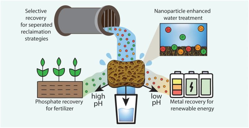
Funded by multiple grants from the U.S. National Science Foundation, researchers created a functional sponge that can soak up certain pollutants from water and then release them on demand, presenting a reusable and low-cost solution for cleaning storm runoff while simultaneously recovering valuable metals like zinc and copper, as well as phosphate.

Using surface iron oxide nanoparticles specialized for capturing specific contaminants, the sponge collects the minerals and then discharges them only when triggered by changes in pH, and it can be used multiple times. The findings were achieved by researchers at Northwestern University and published in the American Chemical Society’s journal Environmental Science and Technology Water.

“The technology can be used as a universal sorbent or ‘catch-all,’ or it can be tailored to certain groups of contaminants like metals, plastics or nutrients,” says Vinayak Dravid, a research author and Northwestern professor of materials science and engineering. In previous iterations, the sponge material has successfully pulled lead, microplastics and oil from water.

Industrial manufacturing and agriculture, in particular, experience mineral and fertilizer loss due to runoff, leaving valuable nonrenewable resources as pollutants in bodies of water. Those resources include heavy metals like zinc and copper and also phosphate.

Credit: Kelly Matuszewski, Northwestern University

Illustration showing how the sponge nanocomposite material recovers phosphate and metals from

Click this link to continue reading the article on the source website.