RSS feed source: Volcano Discovery.com--Global earthquake monitor

Fri, 9 May 2025, 17:55 | BY: EARTHQUAKEMONITOR

An earthquake of magnitude 3.1 occurred only 15 minutes ago 20 miles southwest of Hawkwood, Queensland, Australia, the European-Mediterranean Seismological Centre (EMSC) reported.
The quake hit at a shallow depth of 6.2 miles beneath the epicenter near Hawkwood, North Burnett, Queensland, Australia, early morning on Saturday, May 10th, 2025, at 3:39 am local time. The exact magnitude, epicenter, and depth of the quake might be revised within the next few hours or minutes as seismologists review data and refine their calculations, or as other agencies issue their report.
According to preliminary calculations, we do not expect that the quake was felt by many people and did not cause any damage. In Hawkwood (pop. 18, 20 miles away), and Wandoan (pop. 1,100, 39 miles away), the quake was probably not felt.

If you felt it, report it through our site or app right now!

Download and Upgrade the Volcanoes & Earthquakes app to get one of the fastest seismic alerts online:
Android | IOS
Earthquake data:

I felt this quake

Date & time: May 10, 2025 03:39 am (GMT +10) local time (9 May 2025 17:39 GMT)
Magnitude: 3.0
Depth: 10.00 km
Epicenter latitude / longitude: 25.94°S / 150.55°E (Western Downs, Queensland, Australia)
Primary data source: GeoAu

Click this link to continue reading the article on the source website.

RSS feed source: Volcano Discovery.com--Global earthquake monitor

Date and TimeMag
DepthDistanceLocationDetailsMap May 8, 12:25 pm (GMT +12)

4.5

70 km88 km (54 mi) to the SE Off East Coast of Kamchatka  I FELT IT4 reportsInfoMay 8, 12:16 pm (GMT +12)

4.7

69 km74 km (46 mi) to the SE North Pacific Ocean, 54 km east of Petropavlovsk-Kamchatskiy, Kamchatka, RussiaI FELT IT12 reportsInfoApr 26, 04:31 pm (Kamchatka)

4.3

70 km80 km (50 mi) to the SE North Pacific Ocean, 72 km east of Petropavlovsk-Kamchatskiy, Kamchatka, Russia InfoApr 13, 09:40 pm (Kamchatka)

4.6

81 km90 km (56 mi) to the S North Pacific Ocean, 48 km south of Petropavlovsk-Kamchatskiy, Kamchatka, Russia 17 reportsInfoApr 2, 12:16 am (Kamchatka)

4.3

64 km93 km (58 mi) to the E North Pacific Ocean, 103 km east of Petropavlovsk-Kamchatskiy, Kamchatka, Russia InfoMar 14, 04:11 pm (GMT +12)

4.8

64 km93 km (58 mi) to the SE North Pacific Ocean, 69 km southeast of Petropavlovsk-Kamchatskiy, Kamchatka, Russia 16 reportsInfoJan 27, 01:37 am (Kamchatka)

5.1

56 km92 km (57 mi) to the E 96 km E of Petropavlovsk-Kamchatsky, Russia 20 reportsInfoJan 24, 03:04 am (Kamchatka)

4.7

67 km75 km (47 mi) to the SE North Pacific Ocean, 73 km east of Petropavlovsk-Kamchatskiy, Kamchatka, Russia 5 reportsInfoNov 17, 2024 01:47 am (Kamchatka)

5.0

56 km83 km (52 mi) to the SE 84 km east of Petropavlovsk-Kamchatskiy, Kamchatka, Russia 25 reportsInfoAug 18, 2024 07:10 am (Kamchatka)

7.0

29 km108 km (67 mi) to the SE North Pacific Ocean, 102 km east of Petropavlovsk-Kamchatskiy, Kamchatka, Russia 88 reportsInfoApr 3, 2023 03:06 pm (Kamchatka)

6.5

101 km83 km (52 mi) to the S 23 km SSE of Vilyuchinsk, Russia 105 reportsInfoOct 15, 2018

Click this link to continue reading the article on the source website.

RSS feed source: Volcano Discovery.com--Global earthquake monitor

Researchers have developed a new way to create hydrogels using ultrasound, eliminating the need for toxic chemical initiators. This breakthrough offers a faster, cleaner and more sustainable approach to hydrogel fabrication, and produces hydrogels that are stronger, more flexible and highly resistant to freezing and dehydration. The new method also promises to facilitate advances in tissue engineering, bioadhesives and 3D bioprinting.

Click this link to continue reading the article on the source website.
RSS feed source: Volcano Discovery.com--Global earthquake monitor

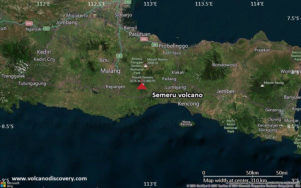
<!–div style="font-size:14px;text-align:center;border:3px solid blue;border-radius:5px;padding:3px;margin:5px;background:#eee"><a href="https://www.volcanoesandearthquakes.com/app/volcano-report.php?volcanoId=44" style="text-decoration:none" target="_blank" rel="noopener noreferrer nofollow" title="Share a volcano (activity) report, submit a photo or other interesting news!” onclick=”window.open(this.href,’Volcano Report’,’status=0,toolbar=0,location=0,directories=0,menubar=0,resizable=1,scrollbars=1,height=500,width=450′);return false”>Send Volcano Report</div–> Stratovolcano 3676 m (12,060 ft)
East Java, Indonesia, -8.11°S / 112.92°E
Current status: erupting (4 out of 5) Semeru volcano eruptions:
1818, 1829, 1830, 1832, 1836, 1838, 1842, 1844, 1845, 1848, 1849(?), 1851, 1856, 1857, 1865, 1866(?), 1887, 1887, 1888, 1889-91, 1892, 1893, 1893-94, 1895, 1896, 1897, 1899, 1899, 1900, 1901, 1903, 1904, 1905, 1907, 1908, 1909-10, 1910-11, 1911, 1912, 1913, 1941-42, 1945, 1946, 1946-47, 1950-64, 1967-ongoing
Typical eruption style
Explosive. Near constant strombolian activity, occasionally stronger explosions, lava flows and pyroclastic flows.

Click this link to continue reading the article on the source website.