RSS feed source: US National Weather Service

At 1115 PM CDT, Doppler radar was tracking a strong thunderstorm 12 miles south of Lake Meredith, or 20 miles north of Amarillo. This thunderstorm was nearly stationary. HAZARD…Wind gusts of 50 to 55 mph and nickel size hail. SOURCE…Radar indicated. IMPACT…Gusty winds could knock down tree limbs and blow around unsecured objects. Minor hail damage to vegetation is possible. Locations impacted include… Pantex.

Click this link to continue reading the article on the source website.

RSS feed source: US National Weather Service

Sat, 14 Jun 2025, 03:46 | BY: EARTHQUAKEMONITOR

Just 14 minutes ago, a 5.5-magnitude earthquake struck near Portoviejo, Provincia de Manabi, Ecuador. The tremor was recorded late at night on Friday, June 13th, 2025, at 10:31 pm local time, at a very shallow depth of 5. km below the surface.
The event was filed by the Institute of Geophysics of the National Polytechnic School in Quito (IGEPN), the first seismological agency to report it.
Based on the preliminary seismic data, the quake should not have caused any significant damage, but was probably felt by many people as light vibration in the area of the epicenter.
Weak shaking might have been felt in Manta (pop. 264,300) located 101 km from the epicenter, Jipijapa (pop. 35,900) 113 km away, Portoviejo (pop. 321,800) 128 km away, Salinas (pop. 43,900) 130 km away, La Libertad (pop. 75,900) 134 km away, and Santa Elena (pop. 42,200) 136 km away.
VolcanoDiscovery will automatically update magnitude and depth if these change and follow up if other significant news about the quake become available. If you’re in the area, please send us your experience through our reporting mechanism, either online or via our mobile app. This will help us provide more first-hand updates to anyone around the globe who wants to know more about this quake.

If you felt it, report it through our

Click this link to continue reading the article on the source website.

RSS feed source: US National Weather Service

Sat, 14 Jun 2025, 01:50 | BY: EARTHQUAKEMONITOR

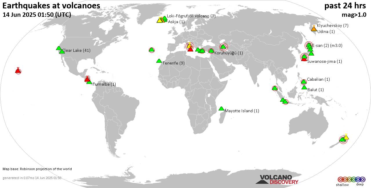
World map showing volcanoes with shallow (less than 50 km) earthquakes within 20 km radius during the past 24 hours on 14 Jun 2025 Number in brackets indicate nr of quakes.

Quakes detected near: Akita-Yake-yama (2 quakes between mag 0.6-1.1), Akyarlar (1 quake mag 2.6), Askja (1 quake mag 1.1), Azuma (1 quake mag 1.5), Balut (1 quake mag 1.7), Brennisteinsfjöll (6 quakes between mag 0.1-1.0)
Cabalian (1 quake mag 2.2), Campi Flegrei (Phlegrean Fields) (7 quakes between mag 0.1-3.0), Clear Lake (41 quakes between mag 0.2-1.8), Coso (9 quakes between mag 0.1-1.8), E-san (2 quakes between mag 3.0-3.0), Eldey (2 quakes between mag 1.2-1.5), Etna (2 quakes between mag 0.9-1.2), Furnas (2 quakes between mag 2.0-2.6), Gede-Pangrango (1 quake mag 2.6), Geureudong (1 quake mag 2.0), Hekla (1 quake mag 1.7), Hulubelu (2 quakes between mag 2.4-2.4), Kilauea (3 quakes between mag 1.7-2.9), Kirishima (7 quakes between mag 0.2-3.0), Klyuchevskoy (7 quakes between mag 0.8-1.4), Kolumbo (7 quakes between mag 1.5-2.1), Koruhüyüğü (1 quake mag 2.3), Ljósufjöll (7 quakes between mag 0.1-1.5), Lokbatan (1 quake mag 3.0), Loki-Fögrufjöll volcano (3 quakes between mag 0.6-2.2), Masaya (2 quakes between mag 2.0-2.1), Mayotte Island (1 quake mag 1.2), Prestahnukur (1 quake mag 1.3), Ruapehu (2 quakes between mag 1.2-3.0), Sousaki (1 quake mag 1.1), Suwanose-jima (1 quake

Click this link to continue reading the article on the source website.
RSS feed source: US National Weather Service

Date and TimeMag
DepthDistanceLocationDetailsMap Jun 7, 07:09 pm (Taipei)

4.0

17 km4.5 km (2.8 mi) to the SE 33 km northeast of Yongkang, TaiwanI FELT IT InfoMay 14, 10:48 am (Taipei)

4.0

10 km10.4 km (6.5 mi) to the N 20 km south of Chiayi City, Taiwan 1 reportInfoMay 13, 03:37 am (Taipei)

4.0

11 km93 km (58 mi) to the E Philippine Sea, 33 km northeast of Taitung, Taiwan 1 reportInfoMay 10, 05:27 am (Taipei)

4.3

20 km68 km (42 mi) to the N 13 km south of Nantou, Taiwan InfoApr 25, 06:10 am (Taipei)

4.1

7.6 km2.2 km (1.4 mi) to the N 27 km south of Chiayi City, Taiwan InfoJan 21, 12:17 am (Taipei)

6.0

16 km8.2 km (5.1 mi) to the SE 39 km northeast of Tainan, Taiwan 79 reportsInfoApr 3, 2024 07:58 am (Taipei)

7.4

40 km132 km (82 mi) to the NE Philippine Sea, 16 km south of Hualien City, Taiwan 232 reportsInfoSep 18, 2022 05:39 pm (Taipei)

5.9

10 km82 km (51 mi) to the E 80 km SE of Lugu, Taiwan 1 reportInfoSep 18, 2022 02:44 pm (Taipei)

6.9

10 km88 km (55 mi) to the E 47 km northeast of Taitung, Taiwan 42 reportsInfoSep 17, 2022 09:41 pm (Taipei)

6.5

10 km95 km (59 mi) to the E 96 km SE of Lugu, Taiwan 65 reportsInfoFeb 6, 2016 03:57 am (Taipei)

6.2

32 km50 km (31 mi) to the SE Taiwan 59 reportsInfoJun 2, 2013 01:43 pm (Taipei)

6.2

17 km92 km (57 mi) to the NE 26 km SE of Puli, Taiwan 24 reportsInfoMar 4, 2010 08:18 am (Taipei)

6.3

21 km46 km (28 mi) to the SE Kaohsiung, 40 km northwest of Taitung, Taiwan InfoDec 26,

Click this link to continue reading the article on the source website.