RSS feed source: US National Weather Service

At 614 PM MDT, Doppler radar was tracking a strong thunderstorm 13 miles northwest of Delle, or 32 miles northwest of Grantsville, moving northeast at 40 mph. HAZARD…Wind gusts of 50 to 55 mph. SOURCE…Radar indicated. IMPACT…Gusty winds could knock down tree limbs and blow around unsecured objects. Locations impacted include… Great Salt Lake South of the Causeway, Great Salt Lake North of the Causeway, Utah Test and Training Range North, Gunnison Island, Hat Island, and Lakeside. This storm will be capable of producing strong gusty winds on the Great Salt Lake. This will lead to a sudden increase in waves and very choppy waters which will result in hazardous boating

Click this link to continue reading the article on the source website.

RSS feed source: US National Weather Service

Sun, 11 May 2025, 23:50 | BY: EARTHQUAKEMONITOR

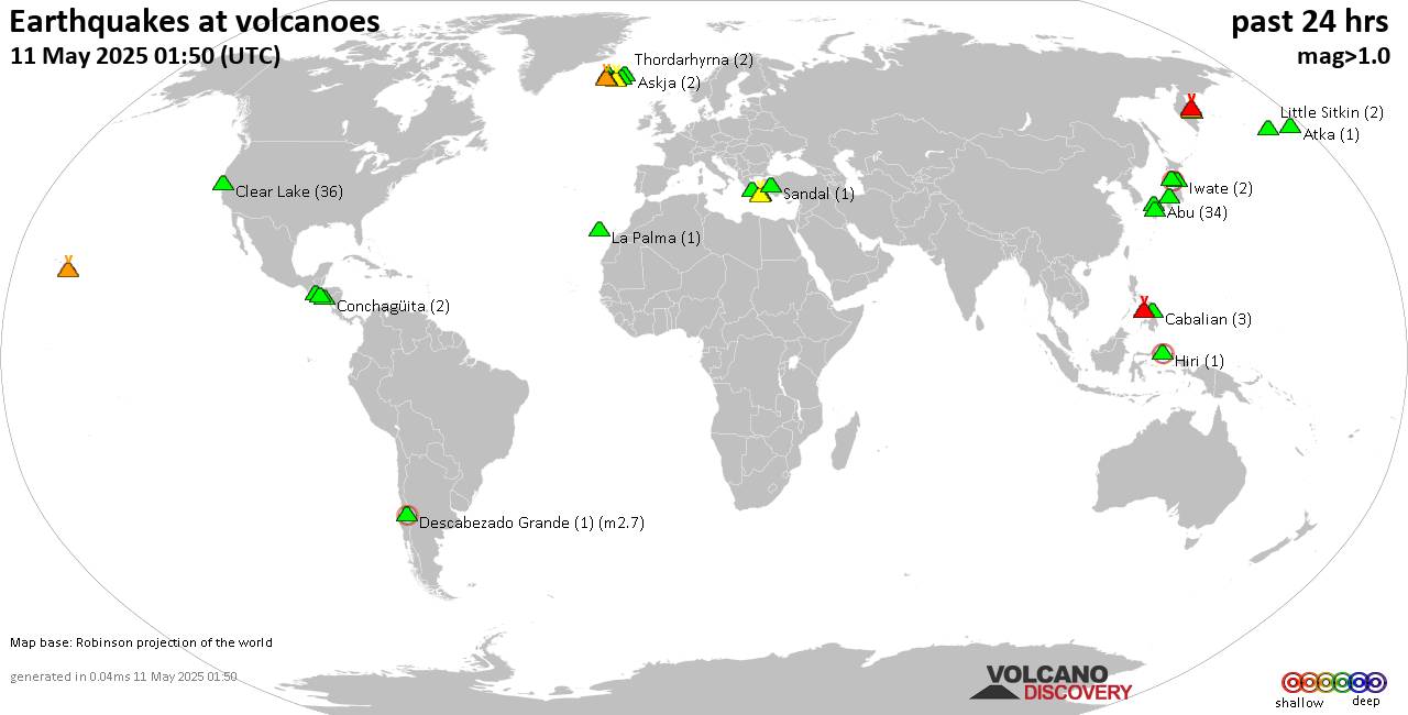
World map showing volcanoes with shallow (less than 50 km) earthquakes within 20 km radius during the past 24 hours on 11 May 2025 Number in brackets indicate nr of quakes.

Quakes detected near: Abu (65 quakes between mag 0.1-1.6), Arayat (1 quake mag 3.0), Asama (1 quake mag 3.0), Bandai (3 quakes between mag 0.4-1.0), Bishoftu Volcanic Field (1 quake mag 3.0), Canlaon (3 quakes between mag 1.5-2.3)
Clear Lake (23 quakes between mag 0.2-1.6), Conchagüita (2 quakes between mag 1.9-2.3), Coso (2 quakes between mag 0.8-1.0), Don Joao de Castro Bank (1 quake mag 2.0), Eldey (7 quakes between mag 0.5-1.5), Etna (2 quakes between mag 0.9-3.0), Gede-Pangrango (1 quake mag 1.6), Hengill (4 quakes between mag 0.1-1.0), Hiuchi (2 quakes between mag 0.4-1.1), Hrómundartindur (6 quakes between mag 0.1-2.0), Kilauea (6 quakes between mag 1.7-2.1), Kizimen (3 quakes between mag 0.5-1.1), Kolumbo (16 quakes between mag 0.9-2.3), Kozushima (1 quake mag 1.9), Kurikoma (1 quake mag 1.0), La Palma (3 quakes between mag 1.5-3.0), Ljósufjöll (4 quakes between mag 0.4-2.0), Lokbatan (1 quake mag 3.0), Mammoth Mountain (1 quake mag 1.6), Maroa (1 quake mag 1.9), Methana (2 quakes between mag 1.7-2.3), Okataina (Tarawera) (2 quakes between mag 1.2-2.7), Prestahnukur (2 quakes between mag 1.2-1.7), Salton Buttes (2 quakes between mag 1.1-1.2), Santorini

Click this link to continue reading the article on the source website.
RSS feed source: US National Weather Service

Date and TimeMag
DepthDistanceLocationDetailsMap May 9, 03:07 pm (Yangon)

4.4

10 km94 km (59 mi) to the N 18 km east of Meiktila, Mandalay Region, MyanmarI FELT IT5 reportsInfoApr 28, 07:57 am (Yangon)

4.4

10 km83 km (52 mi) to the SW Bago Region, 47 km south of Nay Pyi Taw, Nay Pyi Taw, Myanmar 2 reportsInfoApr 19, 12:31 am (Yangon)

4.1

10 km47 km (29 mi) to the NW 1.7 km south of Yamethin, Mandalay Region, Myanmar 4 reportsInfoApr 19, 12:04 am (Yangon)

4.4

10 km78 km (48 mi) to the S 55 km southeast of Nay Pyi Taw, Nay Pyi Taw, Myanmar 3 reportsInfoApr 16, 04:57 pm (GMT +6:30)

4.1

10 km22 km (14 mi) to the NW 46 km north of Nay Pyi Taw, Nay Pyi Taw, Myanmar 1 reportInfoApr 11, 11:28 am (Yangon)

4.9

10 km102 km (63 mi) to the N Nay Pyi Taw, 16 km east of Meiktila, Mandalay Region, Myanmar 2 reportsInfoApr 1, 09:57 pm (Yangon)

4.8

3.2 km24 km (15 mi) to the W 38 km north of Nay Pyi Taw, Nay Pyi Taw, Myanmar 8 reportsInfoMar 29, 03:50 pm (Yangon)

5.1

10 km55 km (34 mi) to the SW 19 km southwest of Nay Pyi Taw, Nay Pyi Taw, Myanmar 14 reportsInfoMar 29, 05:51 am (Yangon)

5.0

10 km12 km (7.7 mi) to the SW 25 km north of Nay Pyi Taw, Nay Pyi Taw, Myanmar 3 reportsInfoMar 28, 01:15 pm (Yangon)

4.9

10 km81 km (50 mi) to the S 52 km south of Nay Pyi Taw, Nay Pyi Taw, Myanmar 35 reportsInfoMar 28, 01:09 pm (Yangon)

4.8

10 km51 km (32 mi) to the

Click this link to continue reading the article on the source website.