RSS feed source: US National Weather Service

…The National Weather Service in Lake Charles LA has issued a Flood Warning for the following rivers in Louisiana… Calcasieu River Near Glenmora Additional information is available at www.weather.gov. * WHAT…Minor flooding is forecast. * WHERE…Calcasieu River near Glenmora. * WHEN…From Wednesday afternoon until further notice. * IMPACTS…At 14.0 feet, Some roads upstream from Glenmora, including Strothers Crossing Road near the community of Calcasieu and Price Crossing Road near Hineston have two to three feet of water over the road and are subject to being closed. Flooding of forested areas near the river will also occur. * ADDITIONAL DETAILS… – At 10:45 AM CDT Monday the stage was 8.2 feet. –

Click this link to continue reading the article on the source website.

RSS feed source: US National Weather Service

…The Flood Warning is extended for the following rivers in Louisiana… Calcasieu River near White Oak Park Calcasieu River Near Salt Water Barrier …The Flood Warning continues for the following rivers in Louisiana…Texas… Atchafalaya River At Morgan City Sabine River Near Deweyville Additional information is available at www.weather.gov. * WHAT…Minor flooding is occurring and minor flooding is forecast. * WHERE…Sabine River near Deweyville. * WHEN…Until further notice. * IMPACTS…At 25.0 feet, Lowest roads beside the river flood around Deweyville and subject to being closed. In addition, low-lying roads in Southwest Beauregard Parish are flooded including Robert Clark Road. Flooding occurs on the south side of Niblett Bluff Park with access roads

Click this link to continue reading the article on the source website.
RSS feed source: US National Weather Service

Mon, 5 May 2025, 15:50 | BY: EARTHQUAKEMONITOR

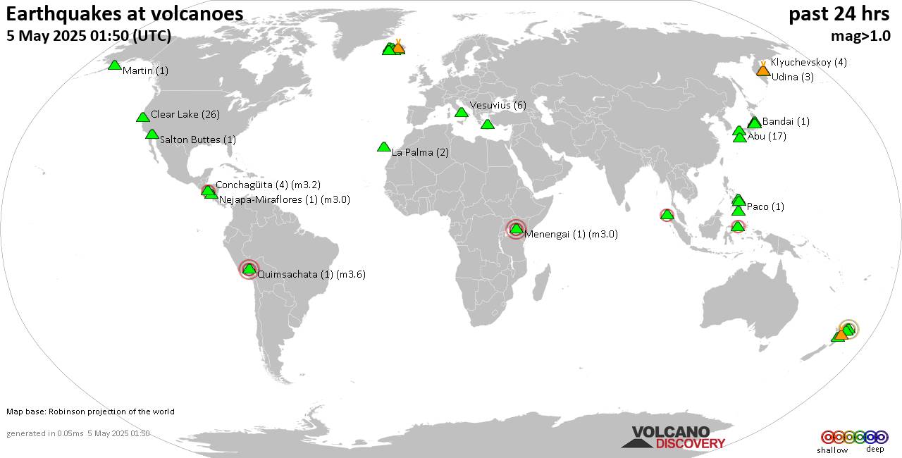
World map showing volcanoes with shallow (less than 50 km) earthquakes within 20 km radius during the past 24 hours on 5 May 2025 Number in brackets indicate nr of quakes.

Quakes detected near: Abu (14 quakes between mag 0.1-1.0), Akagi (1 quake mag 1.4), Ambang (1 quake mag 2.3), Askja (1 quake mag 1.3), Bandai (1 quake mag 1.3), Bardarbunga (10 quakes between mag 0.4-3.0)
Biliran (1 quake mag 2.1), Cabalian (1 quake mag 1.6), Canlaon (1 quake mag 1.5), Clear Lake (22 quakes between mag 0.2-2.2), Conchagüita (4 quakes between mag 2.0-3.2), Cosigüina (1 quake mag 2.5), Coso (2 quakes between mag 1.2-1.3), Fagradalsfjall (6 quakes between mag 0.3-1.1), Golden Trout Creek (1 quake mag 3.0), Guagua Pichincha (1 quake mag 3.0), Hekla (1 quake mag 1.0), Hiuchi (5 quakes between mag 0.2-1.1), Hrómundartindur (3 quakes between mag 0.4-1.0), Irazu (1 quake mag 2.0), Iya (1 quake mag 2.4), Kirishima (2 quakes between mag 0.7-1.3), Klyuchevskoy (3 quakes between mag 1.2-1.5), Kolumbo (12 quakes between mag 0.8-2.2), Krísuvík (3 quakes between mag 0.2-1.2), Ljósufjöll (15 quakes between mag 0.1-3.1), Los Atlixcos (1 quake mag 3.2), Marapi (1 quake mag 2.0), Martin (1 quake mag 1.4), Miravalles (1 quake mag 2.2), Paco (1 quake mag 2.1), Parker (1 quake mag 1.6), Peuet Sague (1 quake

Click this link to continue reading the article on the source website.

RSS feed source: US National Weather Service

Date and TimeMag
DepthDistanceLocationDetailsMap Mar 8, 01:57 am (GMT +11)

4.3

35 km39 km (24 mi) to the SW Coral Sea, 76 km southwest of Anatom Island, Tafea, Vanuatu InfoFeb 20, 07:16 pm (GMT +11)

4.6

10 km57 km (35 mi) to the E South Pacific Ocean, 60 km southeast of Anatom Island, Tafea, Vanuatu InfoFeb 13, 11:18 pm (GMT +11)

4.9

10 km78 km (49 mi) to the W 124 km SSW of Isangel, Vanuatu InfoJan 17, 12:27 am (GMT +11)

5.0

36 km61 km (38 mi) to the SW Coral Sea, 98 km southwest of Anatom Island, Tafea, Vanuatu 1 reportInfoJan 1, 03:52 pm (GMT +11)

4.3

10 km77 km (48 mi) to the SW Coral Sea, 114 km southwest of Anatom Island, Tafea, Vanuatu InfoDec 7, 2023 11:56 pm (GMT +11)

7.1

48 km35 km (22 mi) to the SW Vanuatu 29 reportsInfoSep 14, 2022 10:04 pm (GMT +11)

7.0

137 km105 km (65 mi) to the SE 209 km SSE of Isangel, Vanuatu 28 reportsInfoMar 31, 2022 04:44 pm (GMT +11)

7.0

10 km248 km (154 mi) to the S Southeast of the Loyalty Islands 2 reportsInfoDec 5, 2018 03:18 pm (GMT +11)

7.4

10 km160 km (99 mi) to the S Southeast of Loyalty Islands 44 reportsInfoAug 29, 2018 02:51 pm (GMT +11)

7.1

21 km182 km (113 mi) to the S South Pacific Ocean, 238 km east of Tadine, Loyalty Islands, New Caledonia 3 reportsInfoNov 20, 2017 09:43 am (GMT +11)

7.0

10 km130 km (81 mi) to the SW Loyalty Islands 26 reportsInfoSep 4, 2011 09:55 am (GMT +11)

7.0

185 km25 km (15 mi) to the SE 133 km SSE of Isangel, Vanuatu InfoAug 21,

Click this link to continue reading the article on the source website.