RSS feed source: US National Weather Service

At 817 PM EDT, Doppler radar was tracking strong thunderstorms along a line extending from near Millboro to near Glasgow to near Boonsboro. Movement was north at 40 mph. HAZARD…Wind gusts up to 40 mph and half inch hail. SOURCE…Radar indicated. IMPACT…Gusty winds could knock down tree limbs and blow around unsecured objects. Minor hail damage to vegetation is possible. Locations impacted include… Lexington… Buena Vista… Glasgow… Goshen… Forks Of Buffalo… Big Island… and Rockbridge Baths.

Click this link to continue reading the article on the source website.

RSS feed source: US National Weather Service

Support us – Help us upgrade our services! We truly love working to bring you the latest volcano and earthquake data from around the world. Maintaining our website and our free apps does require, however, considerable time and resources.
We need financing to increase hard- and software capacity as well as support our editor team. We’re aiming to achieve uninterrupted service wherever an earthquake or volcano eruption unfolds, and your donations can make it happen! Every donation will be highly appreciated. If you find the information useful and would like to support our team in integrating further features, write great content, and in upgrading our soft- and hardware, please make a donation (PayPal).

Planned features:

Improved multilanguage supportTsunami alertsFaster responsivenessThanks to your past donations, these features have been added recently:Design upgradeDetailed quake statsAdditional seismic data sourcesDownload and Upgrade the Volcanoes & Earthquakes app to get one of

Click this link to continue reading the article on the source website.

RSS feed source: US National Weather Service

…The National Weather Service in Shreveport has issued a Flood Warning for the following rivers in Louisiana… Cypress Bayou At Wallace Lake affecting De Soto and Caddo Parishes. * WHAT…Flooding is forecast. * WHERE…Cypress Bayou at Wallace Lake. * WHEN…From Tuesday evening until further notice. * IMPACTS…At 151.0 feet, High water will overflow and result in some significant flooding on some secondary roadways around the Southern Kingston Road area. Livestock near the lake should be moved to higher ground. At 154.0 feet, Expect overflow into several roadways near Southern Kingston and Wallace Lake Roads. * ADDITIONAL DETAILS… – At 6:00 PM CDT Monday the stage was 150.1 feet. – Bankfull stage

Click this link to continue reading the article on the source website.

RSS feed source: US National Weather Service

Mon, 5 May 2025, 23:50 | BY: EARTHQUAKEMONITOR

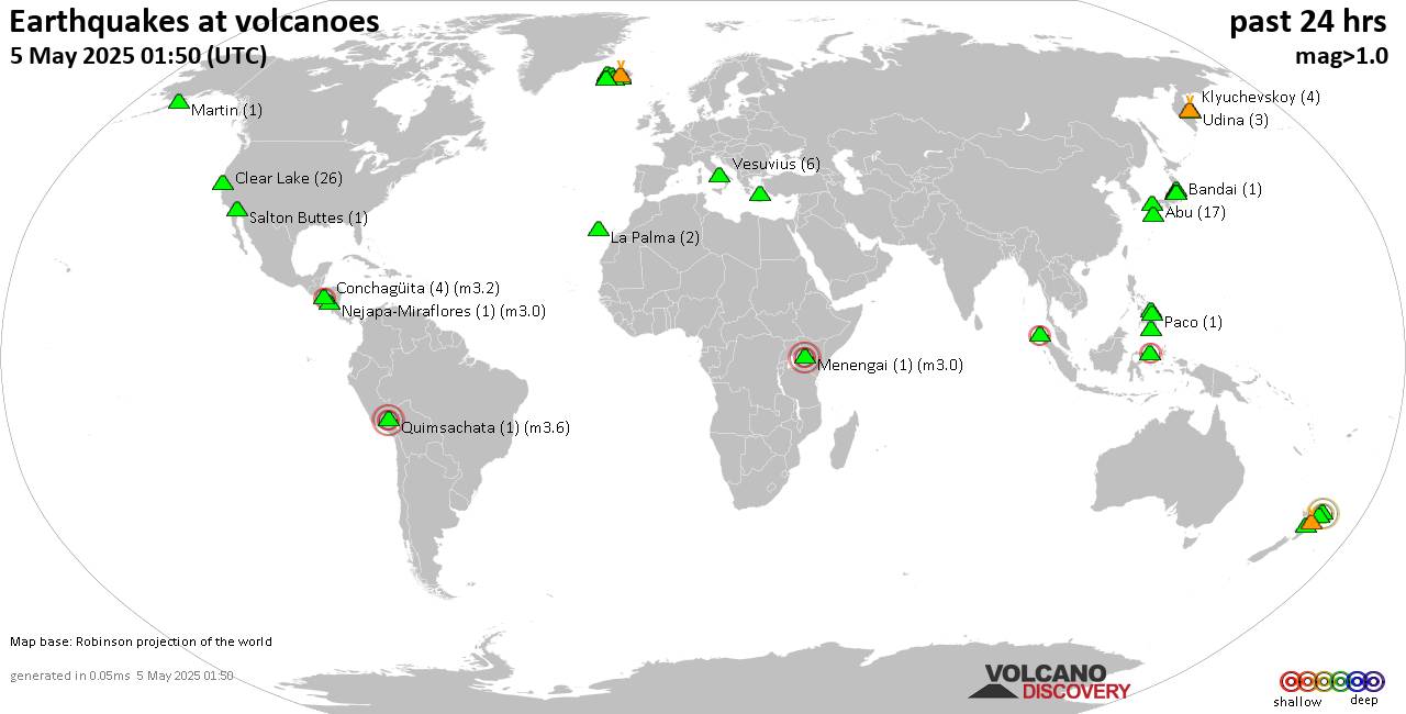
World map showing volcanoes with shallow (less than 50 km) earthquakes within 20 km radius during the past 24 hours on 5 May 2025 Number in brackets indicate nr of quakes.

Quakes detected near: Akagi (1 quake mag 1.4), Aracar (1 quake mag 3.0), Askja (1 quake mag 1.3), Bardarbunga (16 quakes between mag 0.1-5.3), Biliran (1 quake mag 2.1), Campi Flegrei (Phlegrean Fields) (4 quakes between mag 0.1-3.0)
Canlaon (1 quake mag 1.7), Clear Lake (26 quakes between mag 0.2-2.2), Cosigüina (1 quake mag 2.5), Coso (2 quakes between mag 1.2-1.3), E-san (2 quakes between mag 0.8-1.4), Eyafjallajökull (1 quake mag 3.4), Fagradalsfjall (5 quakes between mag 0.3-1.1), Golden Trout Creek (1 quake mag 3.0), Guagua Pichincha (1 quake mag 3.0), Hekla (1 quake mag 1.0), Hrómundartindur (8 quakes between mag 0.4-1.4), Irazu (2 quakes between mag 2.0-2.8), Iya (2 quakes between mag 2.2-2.4), Klyuchevskoy (5 quakes between mag 1.1-1.8), Kolumbo (14 quakes between mag 1.1-2.2), Leonard Range (1 quake mag 1.8), Ljósufjöll (11 quakes between mag 0.3-1.6), Loki-Fögrufjöll volcano (1 quake mag 1.5), Marapi (1 quake mag 1.9), Miravalles (3 quakes between mag 2.2-3.5), Nantai (2 quakes between mag 0.4-1.2), Paco (1 quake mag 2.1), Platanar (1 quake mag 1.4), Poas (1 quake mag 1.4), Reporoa (13 quakes between mag 1.4-2.2), Rinjani (1 quake

Click this link to continue reading the article on the source website.