RSS feed source: Volcano Discovery.com--Global earthquake monitor

Thu, 15 May 2025, 18:00 1747332004 | BY: EARTHQUAKEMONITOR

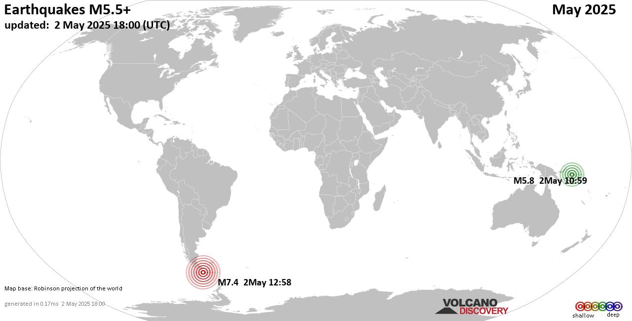
Worldwide earthquakes above magnitude 5.5 during May 2025

Summary: 1 quake 7.0+, 5 quakes 6.0+, 73 quakes 5.0+, 559 quakes 4.0+, 2940 quakes 3.0+, 5581 quakes 2.0+ (9159 total)
This report is being updated every day.
Magnitude 9+: none
Magnitude 8+: none
Magnitude 7+: 1 earthquake
Magnitude 6+: 5 earthquakes
Magnitude 5+: 73 earthquakes
Magnitude 4+: 559 earthquakes
Magnitude 3+: 2940 earthquakes
Magnitude 2+: 5581 earthquakes
No quakes of magnitude 8 or higherTotal seismic energy estimate: 9.4 x 10¹⁵ joules (2622 gigawatt hours, equivalent to 2.3 x 10⁶ tons of TNT or 141 atomic bombs!) | equivalent to ONE quake of magnitude 7.4 learn moreList of 10 largest earthquakes in the world during May 2025:#1: Mag 7.4 South Atlantic Ocean, 236 km southeast of Isla Phillips Island, Region de Magallanes y Antartica Chilena, ChileFriday, May 2, 2025, at 09:58 am (GMT -3) – #2: Mag 6.3 South Atlantic Ocean, 333 km southeast of Isla Phillips Island, Region de Magallanes y Antartica Chilena, ChileFriday, May 2, 2025, at 02:59 pm (GMT -3) – #3: Mag 6.0 156 km west of Gorontalo, Kota Gorontalo, Gorontalo, IndonesiaSaturday, May 3, 2025, at 08:51 pm (Makassar time) – #4: Mag 6.0 Southern East Pacific RiseSunday, May 4, 2025, at 08:55 pm (GMT -7) – #5: Mag 5.8 25 km south of San Cristobal de las Casas, Estado de Chiapas, MexicoMonday,

Click this link to continue reading the article on the source website.

RSS feed source: Volcano Discovery.com--Global earthquake monitor

Date and TimeMag
DepthDistanceLocationDetailsMap Apr 30, 02:13 am (Tijuana)

4.1

10 km52 km (32 mi) to the N 92 km northwest of San Felipe, Estado de Baja California, Mexico 12 reportsInfoSep 2, 2024 01:01 pm (Tijuana)

4.0

7.3 km63 km (39 mi) to the W 51 km northwest of Lazaro Cardenas, Estado de Baja California, Mexico 3 reportsInfoJul 6, 2024 05:47 pm (Tijuana)

4.0

3 km46 km (29 mi) to the N 81 km northwest of San Felipe, Estado de Baja California, Mexico 1 reportInfoMay 28, 2024 12:47 am (Tijuana)

4.2

6.2 km43 km (27 mi) to the N Mexico: 77 km al NOROESTE de SAN FELIPE, BC 8 reportsInfoMay 27, 2024 06:17 am (Tijuana)

4.0

10.1 km49 km (30 mi) to the N 82 km northwest of San Felipe, Estado de Baja California, Mexico InfoMay 27, 2024 04:05 am (Tijuana)

4.2

10 km45 km (28 mi) to the N Mexico: 81 km al NOROESTE de SAN FELIPE, BC 8 reportsInfoFeb 15, 2024 04:49 am (GMT +0)

4.3

2 km97 km (60 mi) to the NE 45 km northeast of San Felipe, Estado de Baja California, Mexico 2 reportsInfoAug 21, 2023 10:03 am (Tijuana)

4.1

2.3 km70 km (44 mi) to the SW North Pacific Ocean, 18 km northwest of Lazaro Cardenas, Mexico InfoMay 14, 2023 05:13 pm (Tijuana)

4.6

10 km81 km (50 mi) to the W North Pacific Ocean, 45 km northwest of Lazaro Cardenas, Mexico 4 reportsInfoMay 14, 2023 08:18 am (Tijuana)

4.8

5 km63 km (39 mi) to the W 48 km northwest of Lazaro Cardenas, Estado de Baja California, Mexico 5 reportsInfoNov 22, 2022 08:39 am (GMT -8)

6.2

10 km91 km

Click this link to continue reading the article on the source website.

RSS feed source: Volcano Discovery.com--Global earthquake monitor

* WHAT…Southwest winds 25 to 35 mph with gusts up to 55 mph expected. * WHERE…Western Mojave Desert. * WHEN…From 11 AM Saturday to 5 AM PDT Sunday. * IMPACTS…Gusty winds will blow around unsecured objects. Tree limbs could be blown down and a few power outages may result. Areas of blowing dust may result in lower visibility and travel impacts.

Click this link to continue reading the article on the source website.

RSS feed source: Volcano Discovery.com--Global earthquake monitor

Date and TimeMag
DepthDistanceLocationDetailsMap Apr 18, 08:09 am (GMT +6)

3.5

98 km39 km (25 mi) to the S Indian Ocean, 78 km southwest of Pulau Babi Island, Indonesia

Info

Apr 17, 06:37 pm (GMT +7)

3.1

21 km53 km (33 mi) to the N Indian Ocean, 26 km southwest of Sinabang, Indonesia

Info

Apr 15, 02:37 am (Pontianak)

3.1

8 km48 km (30 mi) to the E Indian Ocean, 14 km southeast of Pulau Babi Island, Indonesia

Info

Apr 11, 02:20 pm (Pontianak)

3.6

12 km48 km (30 mi) to the E Indian Ocean, 16 km southeast of Pulau Babi Island, Indonesia

Info

Apr 10, 08:17 am (Pontianak)

3.6

10 km50 km (31 mi) to the E Indian Ocean, 16 km southeast of Pulau Babi Island, Indonesia

Info

Apr 8, 02:49 am (Pontianak)

5.8

18 km48 km (30 mi) to the NE Indian Ocean, 13 km southeast of Pulau Babi Island, Indonesia 8 reportsInfoFeb 26, 01:26 pm (GMT +7)

4.0

20 km36 km (23 mi) to the NW Indian Ocean, 55 km southwest of Sinabang, Indonesia InfoFeb 25, 11:03 am (GMT +7)

4.1

20 km32 km (20 mi) to the NW Indian Ocean, 43 km south of Sinabang, Indonesia InfoJan 3, 12:16 pm (GMT +7)

4.1

49 km97 km (60 mi) to the EIndian Ocean, 70 km south of Pulau Ujung Batu Island, Indonesia InfoOct 28, 2024 08:07 pm (Pontianak)

4.6

22 km78 km (49 mi) to the SE Indian Ocean, North Sumatra, 71 km southeast of Pulau Babi Island, Indonesia 1 reportInfoJan 7, 2020 01:05 pm (Jakarta)

6.1

10 km61 km (38 mi) to the N 9.1 km south of Sinabang, Indonesia 25 reportsInfoJul 5, 2014 09:39 am (Universal Time)

6.1

20 km66 km (41 mi)

Click this link to continue reading the article on the source website.