RSS feed source: US National Weather Service

…The National Weather Service in Mobile AL has issued a Flood Warning for the following rivers in Alabama… Tombigbee River Near Leroy affecting Clarke and Washington Counties. For the Tombigbee River…including Coffeeville Dam – upstream, Coffeeville Dam, Leroy…Minor flooding is forecast. * WHAT…Minor flooding is forecast. * WHERE…Tombigbee River near Leroy. * WHEN…From Tuesday afternoon until further notice. * IMPACTS…At 24.0 feet, Flooding of low lying farm and pasturelands begins. Cattle in low lying areas should be moved to higher ground. Water approaches low lying roads on west side of river. * ADDITIONAL DETAILS… – At 8:00 AM CDT Sunday the stage was 19.8 feet. – Forecast…The river is expected to

Click this link to continue reading the article on the source website.

RSS feed source: US National Weather Service

…The Flood Warning continues for the following rivers in Alabama… Black Warrior River At Selden Lock and Dam affecting Marengo, Hale and Greene Counties. .Recent rainfall over the past 48 hours and expected additional heavy rainfall today through Monday over the Black Warrior River basin is expected to produce rises at Selden Lock and Dam. A Flood Warning remains in effect. * WHAT…Minor flooding is forecast. * WHERE…Black Warrior River at Selden Lock and Dam. * WHEN…From Monday afternoon to Wednesday evening. * IMPACTS…At 90.0 feet, Pasture and wood lands begin to flood. Livestock should be moved to higher ground at stages above 90 feet. * ADDITIONAL DETAILS… – At 8:30

Click this link to continue reading the article on the source website.
RSS feed source: US National Weather Service

…The National Weather Service in Mobile AL has issued a Flood Warning for the following rivers in Alabama… Tombigbee River Near Coffeeville Dam affecting Clarke, Choctaw and Washington Counties. For the Tombigbee River…including Coffeeville Dam – upstream, Coffeeville Dam, Leroy…Minor flooding is forecast. * WHAT…Minor flooding is forecast. * WHERE…Tombigbee River near Coffeeville Dam. * WHEN…From Tuesday afternoon until further notice. * IMPACTS…At 29.0 feet, Pastureland becomes flooded. Livestock should be moved to higher ground. Old Ferry Road near the river begins to flood. * ADDITIONAL DETAILS… – At 8:30 AM CDT Sunday the stage was 23.1 feet. – Forecast…The river is expected to rise above flood stage Tuesday afternoon and

Click this link to continue reading the article on the source website.

RSS feed source: US National Weather Service

Sun, 11 May 2025, 13:50 | BY: EARTHQUAKEMONITOR

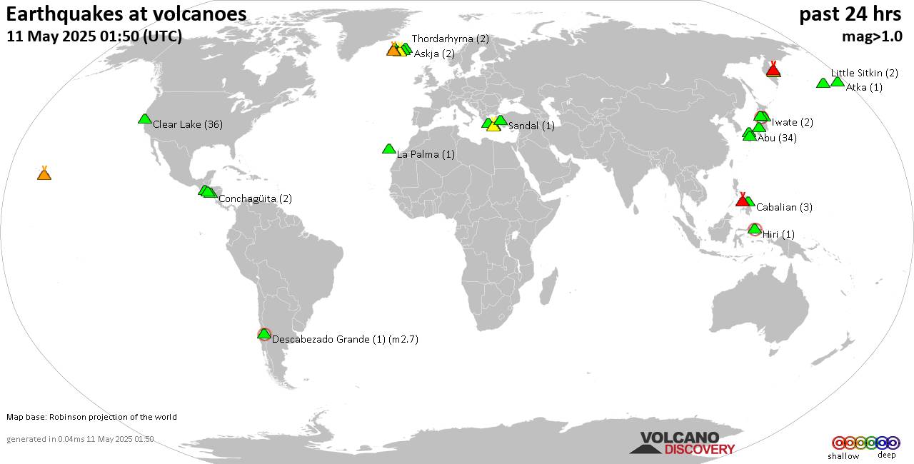
World map showing volcanoes with shallow (less than 50 km) earthquakes within 20 km radius during the past 24 hours on 11 May 2025 Number in brackets indicate nr of quakes.

Quakes detected near: Abu (73 quakes between mag 0.1-1.6), Arayat (1 quake mag 3.0), Askja (1 quake mag 1.0), Bandai (3 quakes between mag 0.4-1.0), Brennisteinsfjöll (28 quakes between mag 0.1-1.2), Cabalian (3 quakes between mag 1.5-1.8)
Canlaon (5 quakes between mag 2.0-3.1), Clear Lake (33 quakes between mag 0.2-1.5), Conchagüita (1 quake mag 2.3), Don Joao de Castro Bank (1 quake mag 2.0), Eldey (5 quakes between mag 0.5-1.5), Hiri (1 quake mag 2.3), Katla (1 quake mag 1.6), Kilauea (2 quakes between mag 1.8-1.9), Klyuchevskoy (12 quakes between mag 0.8-1.6), Kolumbo (14 quakes between mag 1.7-3.1), Krafla (2 quakes between mag 0.6-1.0), Krísuvík (14 quakes between mag 0.0-1.2), Kurikoma (1 quake mag 1.0), La Palma (2 quakes between mag 1.5-1.6), Little Sitkin (4 quakes between mag 1.0-1.9), Ljósufjöll (6 quakes between mag 0.1-2.0), Megata (1 quake mag 2.6), Methana (2 quakes between mag 1.7-2.3), Okataina (Tarawera) (1 quake mag 1.2), Prestahnukur (2 quakes between mag 1.2-1.7), Salton Buttes (1 quake mag 1.3), Santorini (4 quakes between mag 1.2-1.5), Svartsengi (15 quakes between mag 0.0-1.1), Tenerife (1 quake mag 1.6), Tindfjallajökull (1 quake mag

Click this link to continue reading the article on the source website.