RSS feed source: US National Weather Service

…The Flood Warning continues for the following rivers in Arkansas…Missouri… Saint Francis River near Saint Francis For the Saint Francis River…including Saint Francis, Lake City, Madison…Minor flooding is forecast. * WHAT…Minor flooding is occurring. * WHERE…Saint Francis River near Saint Francis. * WHEN…Until early Friday afternoon. * IMPACTS…At 23.0 feet, Most lowland inside the levee system is flooded. * ADDITIONAL DETAILS… – At 8:00 PM CDT Saturday the stage was 23.6 feet. – Recent Activity…The maximum river stage in the 24 hours ending at 8:00 PM CDT Saturday was 23.6 feet. – Forecast…The river is expected to rise to a crest of 23.6 feet just after midnight tonight. It will then

Click this link to continue reading the article on the source website.

RSS feed source: US National Weather Service

At 718 PM PDT, Doppler radar was tracking a strong thunderstorm near Clear Lake National Wildlife Refuge, or 38 miles southeast of Klamath Falls, moving southwest at 20 mph. HAZARD…Winds in excess of 40 mph and half inch hail. SOURCE…Radar indicated. IMPACT…Gusty winds could knock down tree limbs and blow around unsecured objects. Minor damage to outdoor objects is possible. Locations impacted include… Clear Lake National Wildlife Refuge and Newell.

Click this link to continue reading the article on the source website.
RSS feed source: US National Weather Service

* WHAT…Visibility as low as a quarter of a mile in dense fog. * WHERE…In Kansas, Decatur, Graham, and Norton Counties. In Nebraska, Hitchcock and Red Willow Counties. * WHEN…Until 9 AM CDT Sunday. * IMPACTS…Low visibility could make driving conditions hazardous.

Click this link to continue reading the article on the source website.

RSS feed source: US National Weather Service

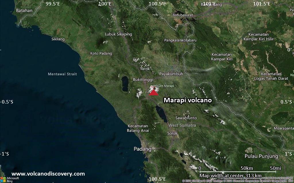
<!–div style="font-size:14px;text-align:center;border:3px solid blue;border-radius:5px;padding:3px;margin:5px;background:#eee"><a href="https://www.volcanoesandearthquakes.com/app/volcano-report.php?volcanoId=62" style="text-decoration:none" target="_blank" rel="noopener noreferrer nofollow" title="Share a volcano (activity) report, submit a photo or other interesting news!” onclick=”window.open(this.href,’Volcano Report’,’status=0,toolbar=0,location=0,directories=0,menubar=0,resizable=1,scrollbars=1,height=500,width=450′);return false”>Send Volcano Report</div–> Stratovolcano 2891 m (9,485 ft)
Western Sumatra, Indonesia, -0.39°S / 100.46°E
Current status: erupting (4 out of 5) Marapi volcano eruptions:
2011-ongoing, 2004 (Aug), 2001, 2000, 1999, 1987-94, 1984, 1984, 1983, 1982, 1980, 1975-79, 1973, 1970-71, 1968(?), 1967, 1966, 1958, 1958, 1954-57, 1950-52, 1949, 1949, 1943, 1932, 1930, 1929, 1927, 1925, 1919, 1918, 1918, 1917, 1916, 1915, 1913, 1911, 1910, 1907-08, 1905, 1904, 1889, 1888, 1886, 1885, 1883, 1878(?), 1883, 1876-77, 1876, 1871, 1871, 1863, 1861, 1855-56, 1854, 1845, 1833-34, 1822, 1807, 1770
Typical eruption style
Small to moderate sized explosions

Click this link to continue reading the article on the source website.