RSS feed source: US National Weather Service

…The Flood Warning continues for the following rivers in Illinois… Kaskaskia River at Carlyle. River forecasts are based on observed precipitation and forecast precipitation for the next 24 hours. * WHAT…Minor flooding is occurring and minor flooding is forecast. * WHERE…Kaskaskia River at Carlyle. * WHEN…Until further notice. * ADDITIONAL DETAILS… – At 8:30 PM CDT Monday the stage was 22.6 feet. – Recent Activity…The maximum river stage in the 24 hours ending at 8:30 PM CDT Monday was 22.6 feet. – Forecast…The river is expected to remain near 22.6 feet over the next several days. – Flood stage is 16.5 feet.

Click this link to continue reading the article on the source website.

RSS feed source: US National Weather Service

Tue, 22 Apr 2025, 00:50 | BY: EARTHQUAKEMONITOR

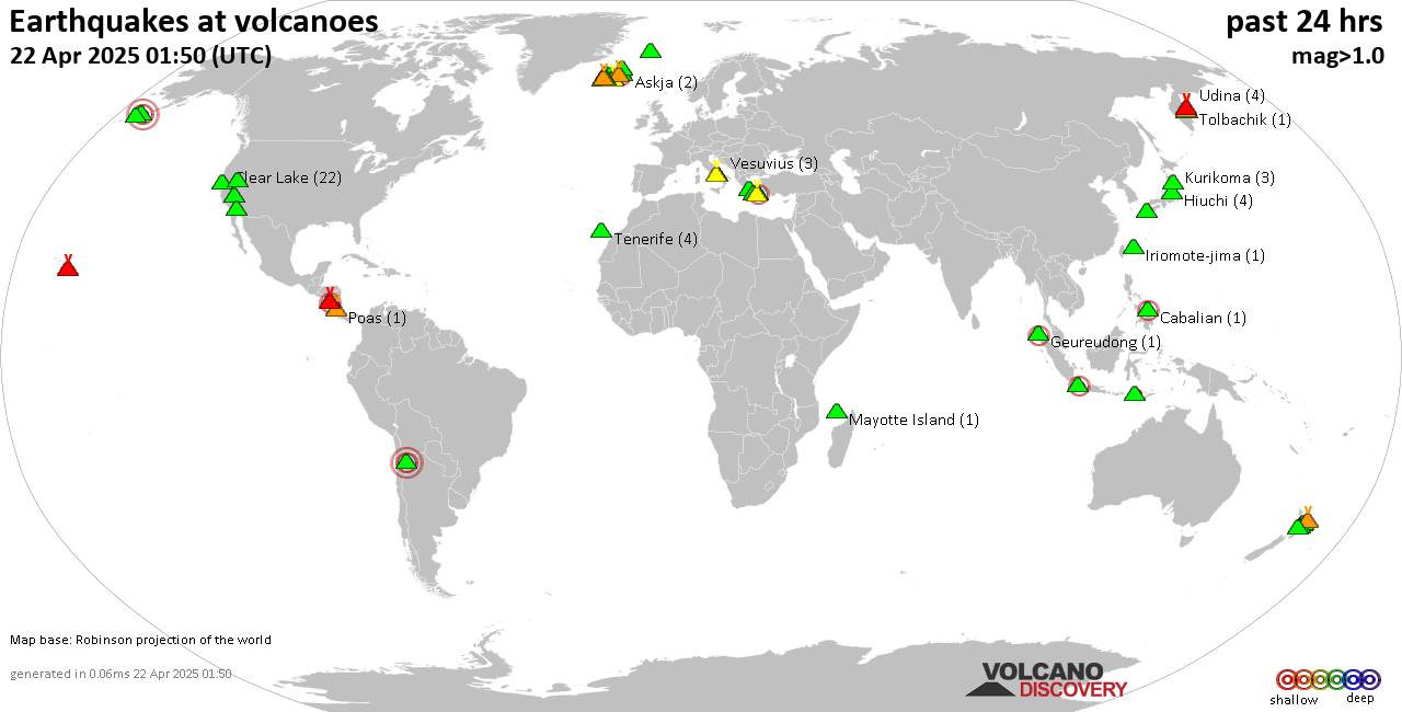
World map showing volcanoes with shallow (less than 50 km) earthquakes within 20 km radius during the past 24 hours on 22 Apr 2025 Number in brackets indicate nr of quakes.

Quakes detected near: Aracar (1 quake mag 3.0), Askja (2 quakes between mag 1.1-1.5), Bardarbunga (1 quake mag 2.4), Brennisteinsfjöll (5 quakes between mag 0.1-1.0), Cabalian (1 quake mag 2.1), Campi Flegrei (Phlegrean Fields) (7 quakes between mag 0.1-1.1)
Clear Lake (22 quakes between mag 0.2-1.6), Coso (3 quakes between mag 1.0-1.1), Eldey (3 quakes between mag 0.7-1.0), Fagradalsfjall (29 quakes between mag 0.1-1.0), Gede-Pangrango (1 quake mag 2.2), Geureudong (1 quake mag 2.0), Hiuchi (4 quakes between mag 0.2-1.4), Hrómundartindur (5 quakes between mag 0.1-2.3), Iriomote-jima (1 quake mag 1.1), Jan Mayen (7 quakes between mag 1.2-1.7), Kilauea (2 quakes between mag 0.7-1.7), Klyuchevskoy (6 quakes between mag 1.2-2.0), Kolumbo (27 quakes between mag 0.6-2.8), Kurikoma (3 quakes between mag 0.2-1.0), Ljósufjöll (9 quakes between mag 0.4-2.0), Masaya (1 quake mag 2.7), Mayotte Island (2 quakes between mag 1.1-1.1), Methana (2 quakes between mag 0.9-1.0), Milos (2 quakes between mag 1.9-2.4), Ndete Napu (1 quake mag 1.6), Poas (1 quake mag 1.9), Reporoa (3 quakes between mag 1.3-1.6), Rotorua (1 quake mag 1.5), Roundtop (4 quakes between mag 1.2-1.5), Salton Buttes (5 quakes between

Click this link to continue reading the article on the source website.

RSS feed source: US National Weather Service

…The Flood Warning continues for the following rivers in Louisiana… Atchafalaya River At Morgan City Additional information is available at www.weather.gov. * WHAT…Moderate flooding is forecast. * WHERE…Atchafalaya River at Morgan City. * WHEN…From Saturday morning until further notice. * IMPACTS…At 7.0 feet, Buildings at the foot of Ann Street on the river side of the flood wall will flood as water overtops the Rio Oil Company dock. Buildings on the river side of the Berwick floodwall will flood. River traffic restrictions will be strictly enforced. In addition, backwater flooding could potentially impact portions areas around Lake Palourde and Stephensville. * ADDITIONAL DETAILS… – At 8:00 PM CDT Monday the stage

Click this link to continue reading the article on the source website.
RSS feed source: US National Weather Service

…The Flood Warning is extended for the following rivers in Illinois… Little Wabash River below Clay City affecting Richland and Clay Counties. .The following forecasts are based on observed precipitation, soil moisture conditions, and forecast precipitation. * WHAT…Minor flooding is occurring and minor flooding is forecast. * WHERE…Little Wabash River below Clay City. * WHEN…Until early Friday morning. * IMPACTS…At 19.7 feet, Mayflower Road…just north of U.S. Route 50…begins to flood. * ADDITIONAL DETAILS… – At 7:45 PM CDT Monday the stage was 19.9 feet. – Recent Activity…The maximum river stage in the 24 hours ending at 7:45 PM CDT Monday was 19.9 feet. – Forecast…The river is expected to rise

Click this link to continue reading the article on the source website.